Mist, Haze and Obscurations
An obscuration is a phenomenon other than precipitation that reduces visibility, either by fine water droplets, as in mist and fog, or by solid particles such as haze, smoke, dust and sand. Blowing snow, flat light and cloud-covered high ground create closely related visual hazards.
An obscuration is anything other than precipitation that cuts visibility by filling the air with particles. Fog is the most familiar and has its own article (see fog); this one covers the others: mist, the thinner relative of fog; haze and smoke; dust and sand raised by the wind, from the desert dust storm to the small dust devil; snow blown up from the ground; and two hazards that can hide the ground from a pilot even when the visibility around the aircraft is good: flat light and obscured high ground.
These phenomena matter at every level of flying. They lower the reported visibility and the runway visual range, they hide terrain and traffic, they distort the pilot's judgement of distance and height, and some of them, dust and sand in particular, damage engines. Under EASA planning guidance, mist, haze, dust and sandstorms count as persistent weather, so a TEMPO or PROB forecast of them must be applied when planning an alternate.
Obscurations versus precipitation
Aviation weather codes separate what falls from what hangs in the air. Precipitation, such as rain (RA), snow (SN) or drizzle (DZ), falls out of cloud. Obscurations stay suspended: mist (BR), fog (FG), smoke (FU), volcanic ash (VA), widespread dust (DU), sand (SA) and haze (HZ). A third group of other phenomena covers dust or sand whirls (PO), squalls (SQ), funnel cloud (FC), duststorm (DS) and sandstorm (SS). US reports add PY, spray (see METAR and SPECI).
The particles themselves divide obscurations into two families. Mist and fog consist of water droplets and need air close to saturation. Haze, smoke, dust and sand are solid particles and can occur in dry air.
Two descriptors apply to material the wind lifts from the surface: DR, low drifting, for snow, dust or sand carried along below about 2 m, and BL, blowing, for the same raised to 2 m or more. BLSN, BLDU and BLSA may also be reported in the vicinity (VC). When an obscuration hides the sky so that no cloud base can be seen, the cloud group gives way to a vertical visibility, such as VV003 for 300 ft; in the United States this counts as a ceiling.
Stability decides how bad an obscuration becomes. An inversion acts as a lid: beneath it the air is smooth, but haze, smoke, dust and moisture accumulate and visibility falls. Unstable air mixes the particles upwards and scrubs the low levels clean, which is why polar maritime air brings crisp visibility between showers.
Mist and haze
Mist (BR) is a suspension of very fine water droplets that reduces visibility less than fog does. Under ICAO rules it is reported when the visibility is 1,000 m or more, up to 5,000 m, with relative humidity above 95 %; below 1,000 m the same droplets are fog. US reports use BR from 5/8 SM to 6 SM. Mist often comes before fog on a clear evening as the temperature closes on the dew point, and a METAR such as 3000 BR with temperature and dew point equal is a warning that it may thicken.
Haze (HZ) is a suspension of dry, solid particles too small to see individually: dust, smoke and other pollution. It is typical of stable air. Beneath a slow-moving anticyclone, subsidence builds an inversion that traps everything released at the surface, so visibility deteriorates day by day, the anticyclonic gloom that surprises pilots who expect a high to mean fine weather. Tropical continental air from North Africa arrives hot, dry and hazy, sometimes carrying Saharan dust.
Haze is often worse than the reported figure suggests. The horizontal visibility at the surface may be moderate while the slant view is poor, especially when looking into the sun, and it usually improves sharply once the aircraft climbs above the inversion. Smoke (FU), from industry or from forest and vegetation fires, behaves like dense haze. Large fires add turbulence and fire-fighting aircraft working at low level; the French AIP, for example, asks crews who see a forest fire to keep at least 5 NM from its outline or at least 1,500 m (5,000 ft) above it.
Haze also misleads the eye. With contrast and detail washed out, the runway seems further away than it is. The FAA's AIM says pilots then tend to fly a lower approach than normal, while some EASA human performance texts say that runway lights dimmed by haze or fog lead to a steeper approach (see visual illusions). Cruising in a uniform haze layer with nothing to focus on, the eyes relax to a short resting focus, empty-field myopia, and distant traffic goes unseen unless the pilot deliberately refocuses on a far object.
Dust storms, sandstorms and haboobs
Widespread dust (DU) and sand (SA) are dust and sand held in suspension in the air. A duststorm (DS) or sandstorm (SS) is the active event, in which a strong, turbulent wind lifts dust or sand from the ground. Heavy duststorms and sandstorms are SIGMET phenomena under ICAO rules; in the United States a non-convective SIGMET is issued for dust or sand storms reducing visibility below 3 SM. Under EASA planning guidance, a dust or sandstorm forecast in a TAF TEMPO or PROB group counts as persistent weather when planning an alternate (see TAF and trend forecasts).
Several named regional winds carry dust (see local winds):
- The Harmattan, a dry, dusty north-easterly from the Sahara towards the ITCZ, blows over West Africa from November to April. It commonly lowers visibility to about 4,000 m, occasionally below 1,000 m near the desert, as at Kano, with dust up to 7,000 to 10,000 ft.
- The Sirocco over Algeria, the Ghibli over Libya and the Khamsin over Egypt are hot, dusty southerly winds that blow ahead of depressions moving along the North African coast and carry dust to thousands of feet. The Sirocco can cut visibility below 1,000 m, and it can travel as far as the French coast, picking up moisture on the way and bringing low stratus, drizzle and fog.
A haboob is a dust storm or sandstorm, most often raised by the outflow from thunderstorms, although strong synoptic winds can also raise one. In the thunderstorm case, the cold downdraughts spread out along the ground as a gust front, which can run far ahead of the storm, and lift loose dust or sand into a moving wall. Haboobs are well known in the Middle East and around Phoenix, Arizona, and can take the visibility from good to near zero within minutes, with windshear and turbulence from the gust front itself (see thunderstorms).
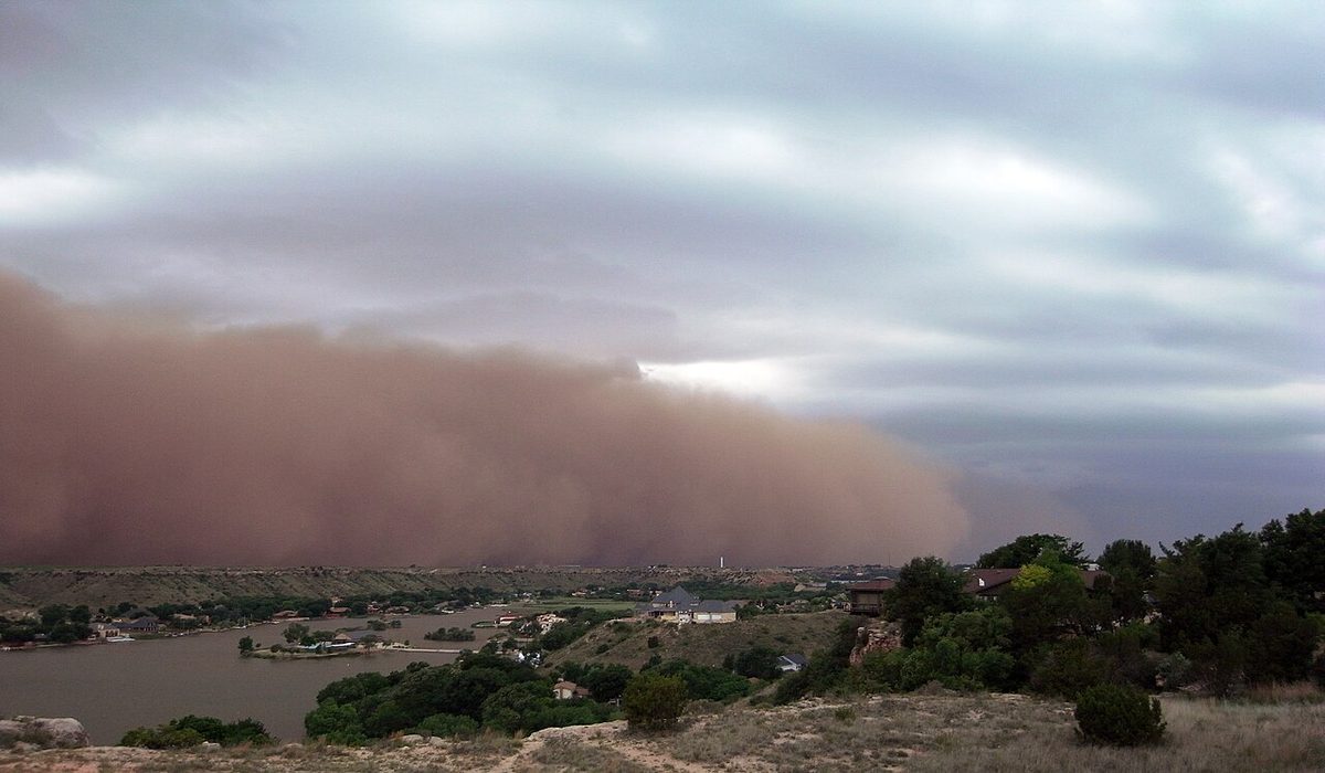
Dust and sand are abrasive. Over time they erode engine blades, and they can block probes. Ingestion can be significant during reverse thrust on the ground, so some operators limit reverse thrust on dusty runways. Volcanic ash, a far more dangerous solid obscuration, is covered in volcanic ash.
Dust devils and willy-willies
A dust devil is a small whirlwind spun up from strongly heated air close to the ground on a hot, clear day. It can rise several hundred feet as a rotating column of dust, and it is reported in METARs as PO, dust or sand whirls. A dust devil is not a tornado: it grows from the surface upwards in clear air, whereas a tornado hangs from a cumulonimbus. It is a sign of strong thermals and shear near the ground, which can upset a light aircraft on take-off or landing; the usual advice is to let it clear the runway before departing.
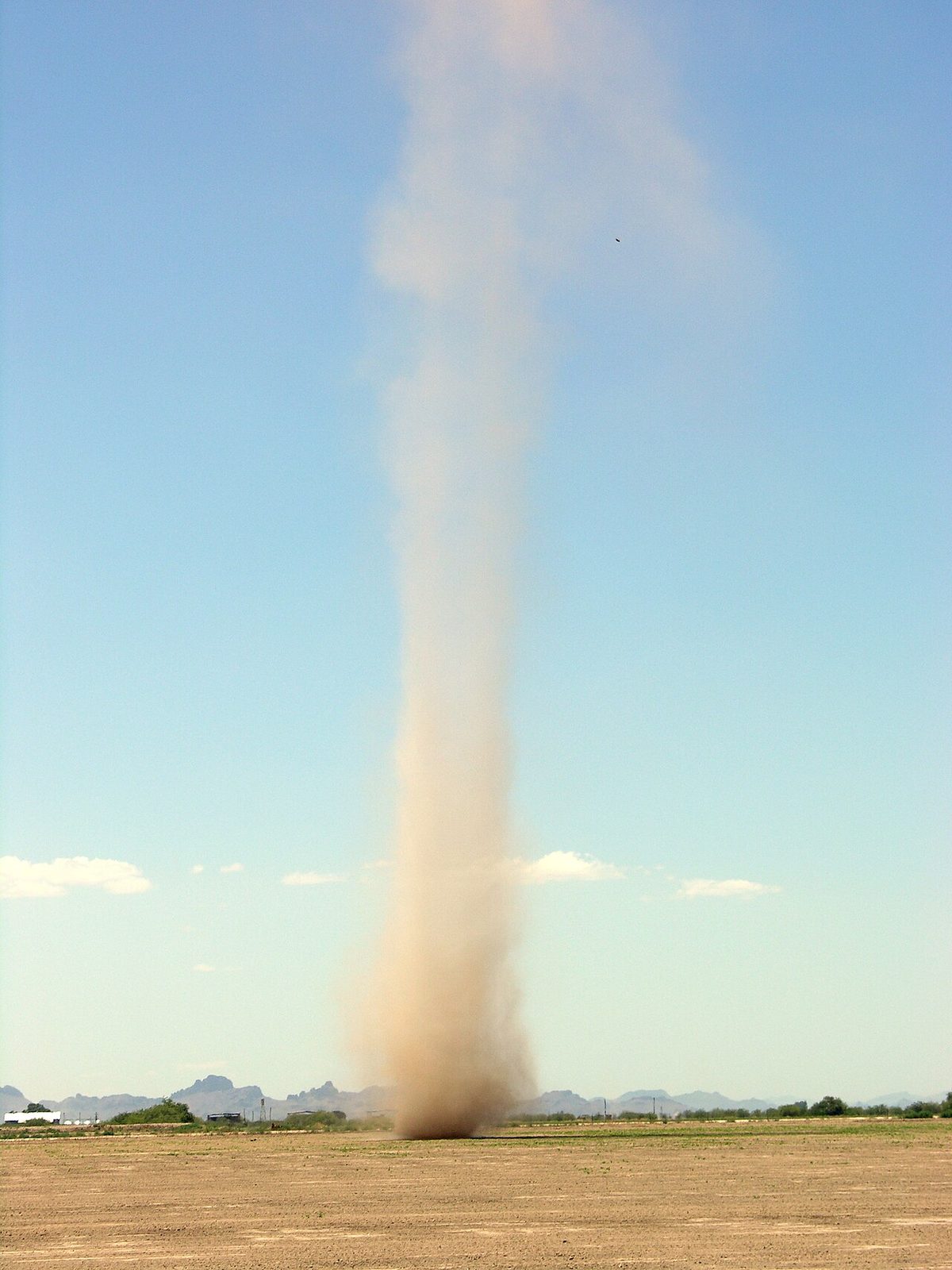
Willy-willy is an Australian name. In everyday Australian usage it means a dust devil. EASA exam material, however, applies it to the dust storms of north-western Australia, raised as air circulates clockwise around a continental low and carried towards the centre and south of the country. The context decides which is meant.
Drifting and blowing snow
Snow already on the ground becomes an obscuration when the wind picks it up. Drifting snow (DRSN) is carried along below about 2 m, where it hardly affects the visibility at eye level. Blowing snow (BLSN) is raised to 2 m or more and reduces visibility severely. EASA exam material gives visibility in falling snow as about 1,000 m when moderate and 50 to 200 m when heavy; drifting snow lowers these values and blowing snow greatly lowers them (see precipitation).
Blowing snow can also deceive the crew on the ground. Taxiing with a tailwind in blowing snow, the flakes may appear to fall vertically, giving the impression that the aircraft has stopped when it is still moving at a fair taxi speed; with a headwind it seems faster than it is.
Flat light and whiteout
Flat light is diffuse, shadowless light over snow, ice or water beneath an overcast sky. With no shadows and no contrast, the eye cannot tell the surface from the sky, and it loses the cues for height, distance and slope. The air itself may be perfectly clear: pilots have flown into snow-covered slopes in good visibility. In whiteout, blowing snow adds a real obscuration to the loss of contrast.
The defences are to avoid VFR flight over featureless snow under an overcast, to fly attitude and altitude by instruments when the surface cannot be judged, and to choose routes along features that give contrast. Whiteout and similar visual illusions are among the conditions in which a serviceable aircraft is flown into the ground (see controlled flight into terrain).
Mountain obscuration
Mountain obscuration means that high ground is hidden in cloud, fog or precipitation, as in hill fog. It is most dangerous when the valleys and lower routes still look open: a VFR pilot can follow a valley into rising ground and find the pass in cloud with no room to turn. Continued VFR flight into cloud in mountainous terrain is a leading cause of fatal accidents.
Forecasts warn of it. In the ICAO system, AIRMET messages cover mountain obscuration, with moderate icing, moderate turbulence and widespread low visibility or cloud, for flights at low level, up to FL100 or FL150 over mountainous areas (see SIGMET, AIRMET and weather warnings). In the United States, G-AIRMET Sierra covers IFR conditions and mountain obscuration; it is issued every 6 hours with snapshots at 3-hour intervals out to 12 hours.
Warning: treat an obscured pass or ridge as closed. Plan a route that does not depend on finding a gap in the cloud, set a turn-back point before committing to a valley, and carry the fuel to use it.
Frequently asked questions
What is the difference between mist and haze?
Mist is made of very fine water droplets and is reported as BR when the visibility is 1,000 m or more, up to 5,000 m, with relative humidity above 95 per cent. Below 1,000 m the same droplets are fog. Haze, reported as HZ, is caused by dry solid particles such as dust and smoke. Both are trapped beneath inversions in stable air, so visibility is often worst under a slow-moving anticyclone.
What is a haboob?
A haboob is a dust storm or sandstorm, most often raised by the outflow from thunderstorms, whose cold downdraughts spread out along the ground and lift loose dust or sand into a moving wall. It is common in desert regions such as the Middle East and around Phoenix, Arizona. As it arrives, visibility can fall from good to near zero within minutes, and the dust can erode engines and block probes.
What is the difference between drifting snow and blowing snow?
Both are snow lifted from the ground by the wind. Drifting snow, coded DRSN, stays close to the surface, below about 2 m, so it hardly affects the visibility at eye level. Blowing snow, coded BLSN, is raised to 2 m or more and can reduce visibility severely, far below the value in falling snow alone. Blowing snow also contributes to whiteout.
What is flat light, and how does it differ from whiteout?
Flat light is diffuse light over snow, ice or water beneath an overcast sky. It removes shadows and contrast, so the eye cannot tell the surface from the sky and cannot judge height or slope, even when the air is clear. Pilots have flown into snow-covered slopes in these conditions. In whiteout, blowing snow adds a physical obscuration to the loss of contrast.
What does mountain obscuration mean in a weather forecast?
It means that high ground is expected to be hidden in cloud, fog or precipitation, even though the valleys may be clear. ICAO AIRMETs include mountain obscuration for flights at low level, and in the United States it is covered by G-AIRMET Sierra together with IFR conditions. For a VFR pilot an obscured pass should be treated as closed, because continuing into cloud over high ground is a classic fatal accident pattern.
Test yourself on Mist, Haze and Obscurations
The v1prep banks cover this topic in Meteorology (050), with a worked explanation for every answer. EASA ATPL, PPL, IR and CPL, the FAA written tests and A320/B737 type ratings.
Start practising →Sources and further reading
- FAA-H-8083-28B, Aviation Weather Handbook
- WMO-No. 782, Aerodrome Reports and Forecasts, A Users' Handbook to the Codes
- Federal Meteorological Handbook No. 1 (FMH-1), Surface Weather Observations and Reports (2019)
- ICAO EUR Doc 014, EUR SIGMET and AIRMET Guide
- FAA Aeronautical Information Manual, Chapter 8, Section 1 (8-1-5 Illusions in Flight, 8-1-6 Vision in Flight)
- American Meteorological Society, Glossary of Meteorology, Haboob
Library articles are written for study and exam preparation. They do not replace your aircraft's approved documentation, your operator's procedures or the regulations themselves.