Thunderstorms
A thunderstorm is a local storm produced by a cumulonimbus cloud and always accompanied by lightning and thunder, usually with strong gusts and heavy showers, sometimes with hail. For aviation it gathers almost every serious weather hazard into a single cell a few miles across.
A thunderstorm (TS in METAR, TAF and SIGMET code) is a storm generated by a cumulonimbus (CB) cloud and, by definition, accompanied by lightning and thunder. Reports combine TS with the precipitation it produces: TSRA is a thunderstorm with rain, +TSRA one with heavy rain, TSGR one with hail, VCTS a thunderstorm in the vicinity and RETS a recent thunderstorm that has ended. CB and towering cumulus (TCU) are the only cloud types named in METAR cloud groups.
A single mature cell can hold severe turbulence, severe icing, hail, lightning, windshear, torrential rain and rapid pressure changes within a few miles, so the working rule for every operator is avoidance by a wide margin.
- Conditions for thunderstorm formation
- Life cycle: cumulus, mature, dissipating
- Air mass, frontal and embedded thunderstorms
- Supercells and tornadoes
- Cumulonimbus features: anvil, overshooting top, mammatus
- Squall lines and gust fronts
- Lightning and static discharge
- Thunderstorm hazards
- Coverage terms: ISOL, OCNL, FRQ, EMBD
- Avoidance and penetration
- Frequently asked questions
Conditions for thunderstorm formation
The thunderstorm formation requirements are three ingredients that must all be present at the same time:
- Moisture. A deep layer of humid air, so that condensation releases large amounts of latent heat.
- Instability. Usually conditional instability, with the environmental lapse rate between the dry and saturated adiabatic rates, so that a saturated parcel stays warmer than its surroundings through a great depth.
- A trigger. Lifting to the level of free convection: surface heating, ascent over high ground, frontal lifting or low-level convergence.
Remove any one and no storm develops. Moisture and instability decide whether storms are possible; the trigger usually decides when and where they appear.
Life cycle: cumulus, mature, dissipating
The convective cloud development stages run from fair-weather cumulus through cumulus congestus (TCU) to cumulonimbus, whose hard, cauliflower top turns fibrous as it glaciates. An ordinary single cell then passes through three stages; the FAA gives about 30 minutes as a typical life cycle.
- Cumulus stage. Updraughts fill the cell and can exceed 3,000 ft/min. Droplets are carried above the freezing level and grow, but nothing reaches the ground.
- Mature stage. It begins when precipitation falls out of the base and reaches the surface. Falling rain and hail drag air down and evaporation chills it, so a strong downdraught develops beside the updraught. The FAA quotes updraughts that may exceed 6,000 ft/min and downdraughts that may exceed 2,500 ft/min. Every hazard peaks, and the top reaches the tropopause and spreads out.
- Dissipating stage. Downdraughts spread through the cell and cut off the warm inflow. Precipitation weakens, but the anvil can linger long after the cell has died.

Exam tip: The mature stage starts when precipitation leaves the cloud base; FAA wording adds "reaching the surface". It is the only stage with updraught and downdraught side by side, hence the worst shear, hail and gust fronts.
In a multicell storm the outflow of one cell triggers new cells along its edge, so the complex can last for hours although each cell is short-lived.
Air mass, frontal and embedded thunderstorms
An air mass thunderstorm, also called a heat or convective storm, forms inside a uniform, unstable air mass, usually triggered by surface heating. Over land it is most frequent on summer afternoons; cells are generally isolated, slow-moving and short-lived. Over the sea the maximum tends to come at night, when the relatively warm water heats air cooling aloft. Orographic storms can stay anchored to windward slopes for hours.
A frontal thunderstorm is triggered by lifting at a front. Along a cold front the storms form in a line and are generally the fastest-moving and most vigorous. At a warm front or occlusion, unstable air lifted over the frontal surface produces cells buried in layer cloud.
That is the origin of the embedded thunderstorm: an embedded cumulonimbus concealed within nimbostratus or altostratus, or hidden by haze. It is reported as EMBD (embedded) and is a particular hazard of warm fronts and occlusions (see fronts). A pilot in cloud has no visual warning; only radar or lightning detection reveals the cells.
Warning: The FAA advises never flying without airborne weather radar into a cloud mass containing scattered embedded thunderstorms.
Supercells and tornadoes
A supercell thunderstorm is dominated by a single, long-lived, rotating updraught called a mesocyclone. It needs deep instability, strong vertical windshear and often a capping stable layer that holds convection back until a great deal of energy has built up. The shear tilts the updraught so that precipitation falls outside it, and the storm can persist for hours, producing the largest hail, damaging winds and most strong tornadoes. In the northern hemisphere supercells often move to the right of the mean wind.
A tornado is a violently rotating column of air in contact with the ground, hanging from a cumulonimbus or occasionally a large cumulus. It shows as a funnel cloud when condensation or debris outlines it; over water it is a waterspout. Its core pressure is extremely low and its winds are the strongest found at the surface.
Cumulonimbus features: anvil, overshooting top, mammatus
When the updraught meets the tropopause or a strong stable layer it spreads sideways, and upper winds carry the glaciated top downwind as the anvil (anvil cloud, cumulonimbus anvil, or incus in the cloud atlas). The anvil points roughly downwind, and hail can fall from it into clear air well away from the core.
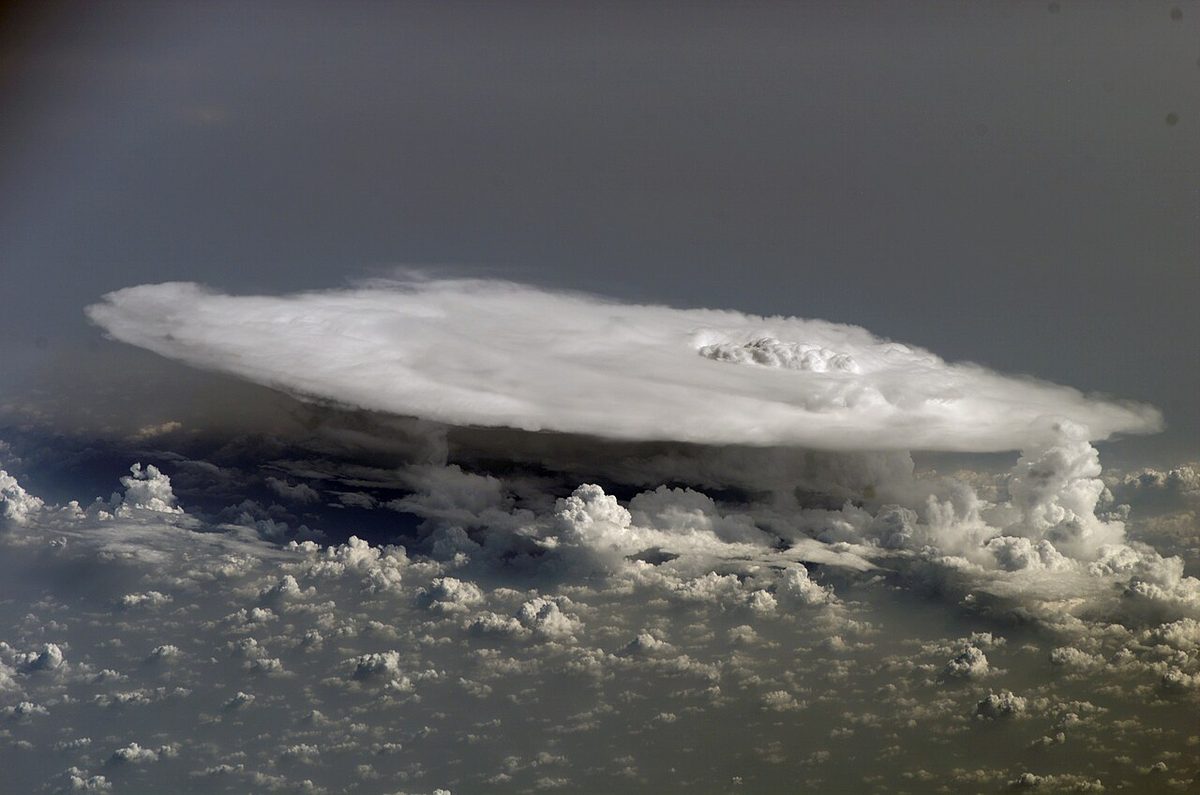
An overshooting top is a dome of cloud pushed above the anvil into the lower stratosphere by an exceptionally strong updraught. It marks a vigorous, often severe cell, with severe turbulence in and above the top.
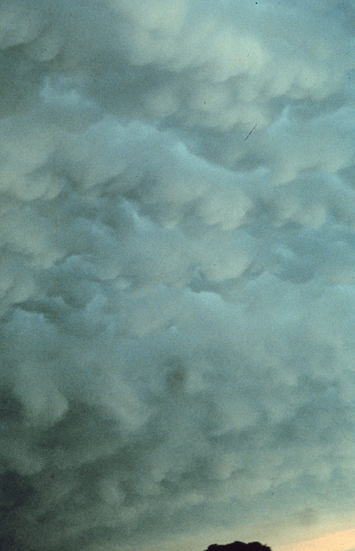
Mammatus are rounded pouches hanging beneath the anvil, where cold, cloudy air sinks into drier air below. They usually accompany a mature, often severe storm, and turbulence in and under the anvil should be expected.
Squall lines and gust fronts
A squall line is a narrow band of active thunderstorms. The FAA describes it as non-frontal, often forming ahead of a fast-moving cold front, and able to extend for hundreds of miles. Usually too tall to overfly and too long to go round, it is in FAA words the single most intense weather hazard to aircraft. SIGMETs report it as SQL TS. Two regional forms appear in ATPL syllabi:
- The West African line squall (West African disturbance line) forms over West Africa in the wet season and moves westward, typically at 20 to 40 kt, as a line several hundred NM long bringing a violent squall and heavy rain. Locally these lines are, confusingly, called "tornadoes".
- The Sumatra (Sumatra squall) forms at night over the Strait of Malacca, where the land breeze from Sumatra meets the prevailing flow, and moves east to reach Singapore before dawn or in the early morning. Most common from April to November, it arrives under an arched squall cloud with gusts of about 20 to 45 kt and heavy rain.
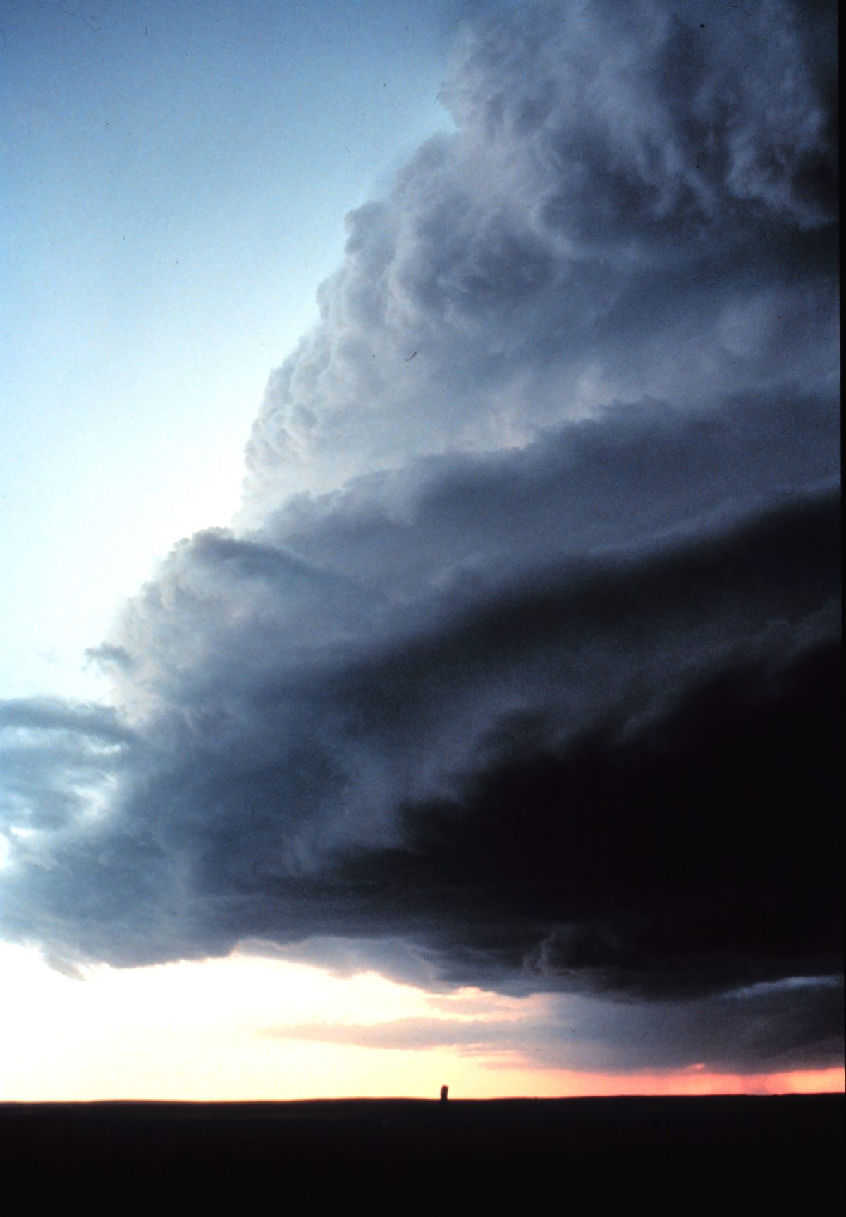
The gust front is the leading edge of the cold outflow spreading from a storm's downdraughts, and can run up to about 15 miles ahead of the precipitation. It brings a sudden wind shift and gust, a temperature fall and a pressure jump, and is a windshear hazard even while the storm is some distance away. It is often marked by a shelf cloud, a wedge-shaped arcus attached to the base of the parent cloud, or a roll cloud, a horizontal tube of cloud detached from the base.
Lightning and static discharge
Collisions between graupel, hail and ice crystals in the presence of supercooled water separate electrical charge. The simplified result is a positively charged upper cloud and a negatively charged lower cloud. Lightning is the discharge that equalises that charge, within the cloud, between clouds or to the ground; thunder is the sound of the heated air expanding violently.
A lightning strike on an aircraft is most likely within about 5,000 ft of the freezing level (roughly +10 °C to −10 °C with a standard lapse rate), in cloud and in or near precipitation, so most strikes happen during climb and descent. The current enters at one extremity and leaves at another, carried by the aluminium skin or by metal mesh in composite structure. Effects include burn marks, damaged radomes, antennas and static wicks, electrical transients and possible compass errors. The flash can blind the crew at night, so cockpit lighting is turned fully up in thunderstorm areas; any strike is followed by a maintenance inspection.
St. Elmo's fire is a corona discharge seen as a bluish-violet glow on the windscreen, nose, wing tips or propeller tips. It is harmless in itself but shows that the air is highly charged and a strike is possible. The same charging causes precipitation static and radio noise, which static wicks help bleed away.
Thunderstorm hazards
The main thunderstorm hazards are:
- Turbulence, severe or extreme, in and beneath the cloud, in clear air around it and above the top; the FAA warns it can extend up to 20 miles from a severe storm (see turbulence).
- Hail, which can be thrown out of the top and fall from the anvil in clear air several miles from the core.
- Icing, as updraughts carry large supercooled drops far above the freezing level, plus ice crystal icing around the anvil (see airframe icing).
- Windshear and microbursts, with microburst downdraughts of up to 6,000 ft/min (see windshear and microbursts).
- Heavy rain, reducing visibility and threatening engine water ingestion and aquaplaning.
- Pressure changes. Pressure falls as a storm approaches, jumps with the first gust, then recovers, a cycle that can take about 15 minutes. The FAA notes that an uncorrected altimeter can then be wrong by more than 100 ft, so QNH must be kept current.
- Lightning and, in the most severe storms, tornadoes.
Airborne radar detects precipitation, not turbulence. Wet hail and heavy rain return strongly, dry hail and ice crystals weakly, and heavy rain can attenuate the beam and hide a cell behind it. Fingers, hooks, scalloped edges and U-shapes suggest hail (see weather radar).
Coverage terms: ISOL, OCNL, FRQ, EMBD
ICAO charts and warnings describe CB and thunderstorm areas with standard CB coverage descriptors, also called convective coverage terms. The spatial coverages come from the ICAO regional SIGMET and AIRMET guides.
| Term | Meaning | Maximum spatial coverage |
|---|---|---|
| ISOL (isolated) | Individual CBs | Less than 50 % |
| Occasional (OCNL) | Well-separated CBs | 50 to 75 % |
| FRQ (frequent) | Little or no separation between cells | More than 75 % |
| EMBD (embedded) | CBs in layers of other cloud or concealed by haze | Not a coverage term |
A SIGMET covers obscured (OBSC), embedded (EMBD), frequent (FRQ) and squall-line (SQL) thunderstorms, with TSGR variants for hail; ISOL and OCNL thunderstorms go in AIRMETs for low-level flights. By convention, a CB area on a significant weather chart implies hail, moderate or severe turbulence and moderate or severe icing.
The United States uses different words: isolated (single cells), widely scattered (under 25 %), scattered (25 to 54 %) and numerous (55 % or more). A US convective SIGMET covers severe or embedded thunderstorms, a line at least 60 miles long with storms along 40 % of it, or storms covering 40 % of an area of at least 3,000 square miles. It is valid for up to two hours and implies severe turbulence, severe icing and low-level windshear.
Avoidance and penetration
Thunderstorm avoidance starts at planning, with TAFs, SIGMETs, significant weather charts, radar imagery and extra fuel for deviations. The FAA AIM guidance, widely used beyond the United States, includes:
- Do not take off or land with a thunderstorm approaching, and never fly under one, even if the far side is visible.
- Avoid any storm identified as severe, or giving an intense radar echo, by at least 20 NM, especially beneath the anvil. Two such cells closer than about 40 NM leave no safe gap.
- Clear the top of a known or suspected severe storm by at least 1,000 ft for every 10 kt of wind at the cloud top, and treat any storm with tops at 35,000 ft or higher as extremely hazardous.
- Go round the entire area if it has six-tenths coverage, and never judge turbulence from a storm's appearance. Frequent, vivid lightning indicates a severe storm.
Airbus recommends the same 20 NM laterally, deviating upwind where hail and turbulence are less likely, and at least 5,000 ft vertically. EASA sets no single avoidance distance in regulation; operators publish minima in the operations manual, normally based on manufacturer guidance.
If a storm cannot be avoided, the FAA technique is to tighten harnesses, choose an altitude below the freezing level or above the −15 °C level to avoid the worst icing, switch on pitot heat and anti-ice, set turbulence penetration speed, turn cockpit lights fully up and disengage autopilot altitude-hold and speed-hold modes. Then hold attitude and heading, accept altitude and speed excursions, and do not turn back once inside: the straight course is usually the quickest way out. Recovery from any resulting upset is covered in upset prevention and recovery.
Frequently asked questions
How far should an aircraft stay away from a thunderstorm?
The FAA AIM advises avoiding any thunderstorm identified as severe, or giving an intense radar echo, by at least 20 NM, especially beneath the anvil. Airbus guidance is similar at 20 NM laterally, preferably on the upwind side, and at least 5,000 ft vertically. Two such cells closer than about 40 NM apart therefore leave no safe gap. EASA sets no single figure; operators publish their own minima.
What are the three stages of a thunderstorm?
A single cell passes through the cumulus stage, with updraughts throughout and no precipitation at the ground; the mature stage, which begins when precipitation falls from the base and reaches the surface, with updraughts and downdraughts side by side; and the dissipating stage, when downdraughts take over and the cell decays. The FAA gives about 30 minutes as a typical life cycle for a single cell.
What does EMBD CB mean on a weather chart?
EMBD means embedded. The cumulonimbus clouds are hidden within layers of other cloud, such as nimbostratus ahead of a warm front or in an occlusion, or concealed by haze. A pilot in cloud cannot see them to avoid them, so airborne weather radar or lightning detection is needed. In a SIGMET the equivalent phrase is EMBD TS.
Is it dangerous for an airliner to be struck by lightning?
Transport aeroplanes are designed to withstand lightning. The current enters at one extremity and leaves at another, travelling through the conductive skin or embedded mesh, and fuel systems are protected against ignition. Strikes can still burn the skin, damage radomes, antennas and composite parts, upset avionics and cause flash blindness, so crews turn cockpit lights up in thunderstorm areas and a post-strike maintenance inspection is required.
Why is a squall line so hazardous to aircraft?
A squall line is a narrow band of active thunderstorms, often ahead of a fast-moving cold front, that can run for hundreds of miles. The FAA describes it as the single most intense weather hazard to aircraft. It is usually too tall to overfly, too dangerous to penetrate or pass beneath, and too long to go round easily, and it brings gust fronts, hail and severe windshear.
Test yourself on Thunderstorms
The v1prep banks cover this topic in Meteorology (050), with a worked explanation for every answer. EASA ATPL, PPL, IR and CPL, the FAA written tests and A320/B737 type ratings.
Start practising →Sources and further reading
- FAA-H-8083-28B, Aviation Weather Handbook (chapter on thunderstorms)
- FAA Aeronautical Information Manual, Chapter 7, Section 1 (Thunderstorms, Thunderstorm Flying)
- FAA Advisory Circular AC 00-24C, Thunderstorms (cancelled, superseded by FAA-H-8083-28)
- ICAO EUR Doc 014, EUR SIGMET and AIRMET Guide
- Airbus Safety First, Optimum Use of the Weather Radar
- Meteorological Service Singapore, Weather Systems (Sumatra squalls)
- SKYbrary, West African Disturbance Line (WADL)
Library articles are written for study and exam preparation. They do not replace your aircraft's approved documentation, your operator's procedures or the regulations themselves.