Local Winds
A local wind is a wind whose direction and strength over a limited area are set by local heating, cooling or terrain rather than by the large-scale pressure pattern alone. Sea and land breezes, katabatic and valley winds, the föhn and the named regional winds are examples.
Local winds are winds that owe their direction and strength to local conditions rather than to the pressure pattern on the synoptic chart. A coast, a mountain slope, a valley or a strait can produce a wind that a forecast for the wider area does not show, reverse the wind at an aerodrome, or turn a moderate gradient wind into a gale.
Pilots meet them as unexpected crosswinds and tailwinds, as wind shear and turbulence on the approach, and as sudden changes of runway in use. EASA theory syllabi also examine a list of named regional winds, from the Mistral to the Southerly Buster, and their typical weather.
What makes a wind local
Local winds fall into three groups:
- Thermal winds of the day and night cycle. Sea and land breezes and anabatic and katabatic slope winds are driven by differences in heating. They show best when the pressure gradient is slack, as in an anticyclone or a col, so that the gradient wind does not swamp them.
- Winds shaped by terrain. The föhn, valley winds and gap winds need a gradient wind to start with; the mountains and valleys then warm, dry, channel or accelerate it.
- Named regional winds. These are driven by the large-scale pressure pattern of a season, but local geography gives them their character and a name.
Sea and land breezes
The land has a low thermal capacity and only a thin layer of it is heated, so it warms quickly in the sun. The sea mixes the heat through a deep layer and hardly changes temperature through the day. By late morning on a sunny day the air over the land is warmer, it expands and rises, the surface pressure over the land falls slightly, and cooler air flows in from the sea. This onshore flow is the sea breeze, with a return flow aloft closing the circulation.
ATPL texts give a typical sea breeze of about 10 kt, reaching 8 to 14 NM inland; in the tropics it is 15 kt or more and penetrates further. It usually sets in late in the morning, strengthens through the afternoon and dies away in the evening. It is most marked on sunny days in anticyclonic weather, when the gradient wind is light. Its leading edge, where the cool marine air meets the warmer air inland, can bring an abrupt wind change and low-level wind shear. Where the sea is cold, the sea breeze can also carry advection fog inland, as on the Atlantic coast of north-west Africa.
At night the land cools below the sea temperature and the circulation reverses as a land breeze. It is weaker than the sea breeze, because the night-time temperature difference is smaller: typically about 5 kt, extending about 5 NM out to sea. Along the Strait of Malacca the land breeze from Sumatra, helped by katabatic flow from its mountains, drives the night-time squall lines known as Sumatras (see thunderstorms).
Exam tip: Sea breeze: by day, onshore, about 10 kt, 8 to 14 NM inland. Land breeze: by night, offshore, about 5 kt, about 5 NM out to sea.
Anabatic, katabatic and valley winds
An anabatic wind blows up a slope by day. Sunshine heats the slope, especially one facing the sun, which in the northern hemisphere means a south-facing slope. The air in contact with it warms and flows upslope. It is light, about 5 kt in ATPL texts, and easily masked by the gradient wind.
A katabatic wind blows down a slope at night. Under a clear sky the slope loses heat by radiation, the air in contact with it cools, becomes denser than the air at the same level away from the slope, and drains downhill under gravity. It averages about 10 kt, but it is most marked when the slope is snow-covered, the sky is clear and the pressure gradient is slack, and over large snowfields and ice sheets it can become strong. The cold air collects in valley bottoms and hollows, which is why radiation fog and frost form there first. At a valley aerodrome a katabatic flow can give an unexpected tailwind or crosswind around dawn.
FAA material uses different words for the same pair of slope winds: a valley breeze blows up the slopes by day and a mountain breeze down them at night. In EASA texts a valley wind (or ravine wind) is something else: a gradient wind channelled along a valley and strengthened by the constriction. Examples are the Mistral in the Rhône valley, the Kosava along the Danube and the Vardarac at Thessaloniki.
The föhn effect
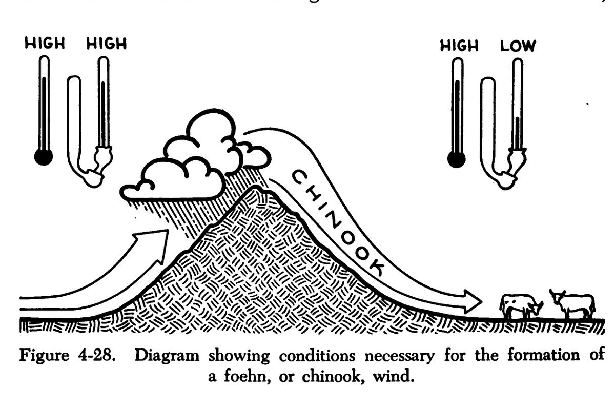
The föhn effect produces a warm, dry wind on the lee side of a mountain range. On the windward side moist air is forced to rise. Until it reaches its condensation level it cools at the dry adiabatic lapse rate, 1 °C per 100 m (about 3 °C per 1,000 ft). In cloud it cools more slowly, at the saturated rate, about 0.6 °C per 100 m (1.8 °C per 1,000 ft) near the surface in temperate latitudes, because condensation releases latent heat. Much of the water falls as rain or snow on the windward slopes. The air crosses the crest with little moisture left, and on the way down it warms at the dry rate over the whole descent.
A simple example shows the result. Air at 15 °C at sea level reaches its condensation level at 1,000 m at 5 °C, then climbs in cloud to a crest at 3,000 m, cooling to about −7 °C. Descending 3,000 m on the lee side at 1 °C per 100 m, it arrives at sea level at about 23 °C: 8 °C warmer than it started, and much drier.

Typical signs are a cap cloud over the crest, which spills a short way down the lee slope and evaporates there; clear skies and good visibility on the lee side; and a warm, dry, gusty wind. The same airflow can also set up mountain waves downwind, and a low may form in the lee of the range, as the Genoa low does in the lee of the Alps.
Two named föhn winds are regularly examined:
- Chinook. Blows down the eastern, lee side of the Rocky Mountains, from southern Colorado to the Mackenzie basin in Canada, mostly in winter. Rises of 20 °C in 15 minutes are not unusual; it can blow for days and clear the snow from the eastern slopes.
- Zonda. The föhn wind on the eastern, lee side of the Andes in South America.
Note: Not every wind down a mountainside is a föhn. The Bora is a cold, katabatic wind, and the Mistral a cold valley wind. A föhn is defined by the warming and drying the air undergoes on its way over the range.
Venturi and gap winds
Where the wind is forced through a gap, along a narrowing valley or through a strait, it accelerates, like air in the throat of a venturi tube. This Venturi effect has two consequences. The wind in the gap can be far stronger than the gradient wind would suggest. And the higher speed brings a local fall in pressure, so an altimeter over-reads: the true altitude is lower than indicated. The same effect occurs over mountain ridges in stable conditions, where it reduces terrain clearance just where it matters.
Named winds of Europe and the Mediterranean
| Wind | Where | Character |
|---|---|---|
| Mistral | Down the Rhône valley, between the Massif Central and the Alps, to the French Mediterranean coast and beyond | Cold valley wind, usually in winter, with high pressure over central France and low pressure over the Gulf of Genoa; 40 to 75 kt in ATPL texts; turbulent |
| Bora | Down onto the north Adriatic coast | Cold, part valley and part katabatic, examined by EASA as katabatic; high over central Europe or the Balkans, low over the Adriatic; about 70 kt with gusts above 100 kt; strongest and most frequent in winter |
| Etesian | From the north across the Aegean towards Rhodes | Persistent and dry, between the Azores ridge to the west and heat-induced low pressure to the east; clear skies and good visibility, gales when strong |
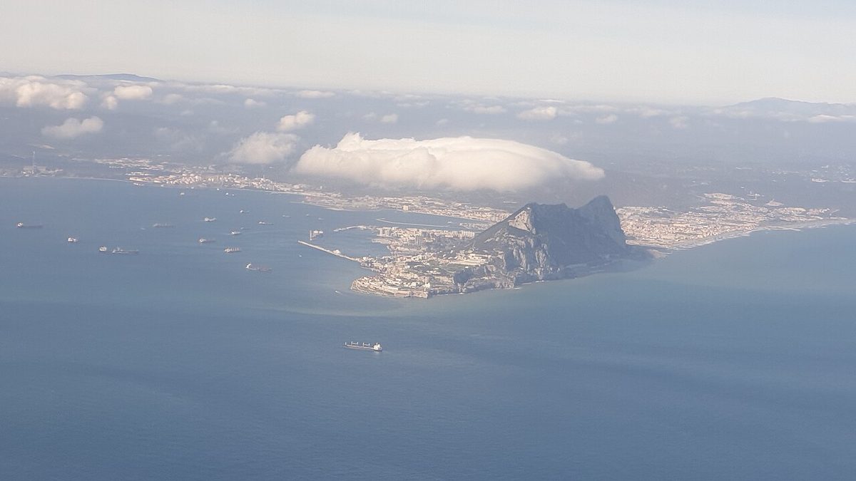
| Levanter | From the east through the Strait of Gibraltar | Mainly July to October and in March, at times gale force; a banner of stratus or stratocumulus streams west from the Rock, with turbulence up to 5,000 ft above the airfield |
| Vendaval | From the south-west or west in the Strait of Gibraltar | Strong and very squally, with low cloud, ahead of cold fronts approaching from the Atlantic |
| Sirocco | From the south over Algeria and across the Mediterranean | Hot, dusty desert wind, mainly in spring, ahead of depressions tracking along the North African coast; visibility can fall below 1,000 m; crossing the sea it picks up moisture and can bring low stratus, drizzle and fog as far as the French coast |
The Ghibli of Libya and the Khamsin of Egypt belong to the same family as the Sirocco: hot, dusty southerly winds from the desert, blowing ahead of depressions tracking along the North African coast and carrying dust to several thousand feet.
Named winds of Africa, the Americas and Australia
- Harmattan. The north-east trade wind of West Africa, blowing from the high pressure over the Sahara towards the intertropical convergence zone between about November and April. It is dry and dusty; the dust can extend to 7,000 to 10,000 ft, visibility is frequently reduced to about 4,000 m and occasionally below 1,000 m, as at Kano in northern Nigeria. In summer the south-west monsoon replaces it as the convergence zone moves north.
- Chinook and Zonda. The föhn winds of the Rockies and the Andes, described above.
- Southerly Buster. At Sydney in summer, the passage of a polar front cold front brings a sharp back of the wind to the south, a sudden drop in temperature, cumulus and cumulonimbus and squalls. In the southern hemisphere a cold front brings a back where the northern hemisphere would have a veer.
Operational effects of local winds
- Runway and wind changes. A sea breeze or katabatic flow can reverse the surface wind at an aerodrome, turning a headwind into a tailwind or a strong crosswind. Expect the change in the ATIS and plan the fuel and performance for the other runway.
- Wind shear and turbulence. Shear occurs at the boundary between a sea breeze or katabatic flow and the wind above it, and in the lee of hills and buildings. Föhn, Mistral, Bora and Levanter bring turbulence at low level, and the föhn can be accompanied by mountain waves and rotor.
- Visibility. Harmattan, Sirocco, Ghibli and Khamsin dust can reduce visibility below aerodrome minima, and katabatic drainage brings radiation fog to valley aerodromes first.
- Performance and altimetry. The warm föhn raises density altitude and lengthens take-off distances, and Venturi flow through gaps and over ridges makes the altimeter over-read.
Local knowledge counts for much. National AIPs often warn of local wind effects in the aerodrome section, and aerodrome forecasts and warnings from the local meteorological office are the best guide to when a named wind will blow (see surface wind).
Frequently asked questions
What causes a sea breeze?
On a sunny day the land heats up much faster than the sea. Air over the land warms, expands and rises, the surface pressure falls slightly, and cooler air flows in from the sea to replace it. The sea breeze usually sets in late in the morning, peaks in the afternoon and dies away in the evening. At night the process reverses and a weaker land breeze blows out to sea.
What is the difference between an anabatic and a katabatic wind?
An anabatic wind blows up a slope by day, when sunshine heats the slope and the air in contact with it rises. It is light, about 5 kt, and easily masked by the gradient wind. A katabatic wind blows down a slope at night, when the slope cools by radiation and the chilled, denser air drains downhill. It is strongest over snow-covered slopes under a clear sky with a slack pressure gradient.
What is a föhn wind?
A föhn is a warm, dry wind on the lee side of a mountain range. Moist air forced up the windward side cools at the slower saturated rate once cloud forms and loses water as precipitation. On the lee side it descends with little or no cloud and warms at the faster dry adiabatic rate, so it arrives warmer and drier than it was at the same level on the windward side. The Chinook and the Zonda are examples.
Is the Bora a föhn wind?
No. The Bora is a cold wind that blows down onto the north Adriatic coast, strongest and most frequent in winter, when high pressure lies over central Europe or the Balkans and low pressure over the Adriatic. ATPL texts describe it as partly a valley wind and partly katabatic, and EASA examines it as a katabatic wind. A föhn is warm and dry because of what happened to the air on its way over the mountains.
What is the Harmattan?
The Harmattan is the dry, dusty north-easterly wind of West Africa, the north-east trade wind blowing from the Sahara towards the intertropical convergence zone between about November and April. The dust it carries can reach 7,000 to 10,000 ft, often reduces visibility to a few kilometres and at times below 1,000 m, especially near the desert fringe at places such as Kano in Nigeria.
Test yourself on Local Winds
The v1prep banks cover this topic in Meteorology (050), with a worked explanation for every answer. EASA ATPL, PPL, IR and CPL, the FAA written tests and A320/B737 type ratings.
Start practising →Sources and further reading
Library articles are written for study and exam preparation. They do not replace your aircraft's approved documentation, your operator's procedures or the regulations themselves.