Precipitation
Precipitation is water that falls from cloud as liquid drops or solid ice, such as rain, drizzle, snow, hail or ice pellets, after cloud particles have grown large enough to fall. Its form and character depend on the cloud that produces it and on the air it falls through.
Precipitation is water that falls out of cloud as liquid drops or solid ice: rain, drizzle, snow, hail, ice pellets and their variants, and also the trailing streaks that evaporate before they reach the ground. Every cloud contains water, but only some clouds precipitate, because cloud droplets are far too small to fall against even a gentle updraught. They must first grow, by one of two processes, into particles heavy enough to leave the cloud.
For a pilot precipitation is both a hazard and a clue. It cuts visibility, contaminates runways, can freeze on contact with the airframe and, as heavy rain or hail, threatens engines and structure. Its type and character also reveal the cloud that produced it and the stability of the air: steady rain means layer cloud and stable air, while showers mean heap cloud and convection.
How precipitation forms
Cloud forms when rising air cools to its dew point and water vapour condenses on microscopic airborne particles, the condensation nuclei (see cloud formation and types). The droplets are so light that they stay suspended, and a cloud can last for hours without a drop reaching the ground. To fall out, the particles must grow many times larger. Meteorology recognises two ways in which they do so:
- the ice crystal process, or Bergeron process, which needs a cloud colder than 0 °C containing both supercooled droplets and ice;
- the coalescence process, which works among liquid droplets and is the only mechanism available in a cloud warmer than 0 °C throughout.
The Bergeron (ice crystal) process
The Bergeron theory, in full the Wegener-Bergeron-Findeisen theory, rests on the behaviour of water below 0 °C. Cloud droplets do not freeze at 0 °C, because freezing needs a freezing nucleus and these are much scarcer than condensation nuclei. Clouds colder than 0 °C are therefore full of supercooled water droplets, common down to about −20 °C, with small ones surviving to about −40 °C. Ice crystals form among them wherever freezing nuclei are present.
Below 0 °C the saturation vapour pressure over water is greater than over ice. Air that is just saturated with respect to the droplets is therefore supersaturated with respect to the crystals. Vapour is deposited directly onto the ice, the droplets evaporate to replace it, and the crystals grow at the droplets' expense. They grow further by colliding with supercooled droplets, which freeze onto them, and by joining together into snowflakes. Once heavy enough they fall, and the temperature of the air beneath decides whether they arrive as snow or melt on the way down into rain.
The process explains why deep layer cloud such as nimbostratus, whose upper part lies well below 0 °C, produces prolonged precipitation, and why airframe icing becomes lighter as a cloud turns to ice.
Exam tip: the key statement of the Bergeron theory is that, below 0 °C, the saturation vapour pressure over water is greater than over ice, so ice crystals grow at the expense of supercooled water droplets.
The coalescence process
The coalescence theory explains precipitation from clouds made of liquid water, including clouds warmer than 0 °C throughout, where the Bergeron process cannot operate. A cloud always holds a range of droplet sizes. The larger droplets fall faster than the small ones, overtake them, collide and merge. Each merger makes a drop larger and faster-falling, so it sweeps up more droplets, until it is too heavy for the updraught to support and falls out as drizzle or rain.
Coalescence also produces freezing drizzle. In shallow stratiform cloud that is below 0 °C throughout, supercooled droplets can grow by collision and coalescence into drizzle-sized drops without any warm layer aloft. Freezing drizzle formed this way is hard to forecast and brings the supercooled large droplet hazard described in airframe icing.
Continuous, intermittent and showery precipitation
Precipitation is classified by its character as well as its form, and the character follows the cloud.
- Continuous precipitation falls without a break for 60 minutes or more. It comes from layer cloud in stable air, above all nimbostratus at a warm front or occlusion, and covers a wide area.
- Intermittent precipitation also falls from layer cloud, but stops and starts without the cloud breaking between spells.
- Showers fall from heap cloud, cumulus and cumulonimbus, built by convection in unstable air. They begin and end abruptly, vary quickly in intensity and are separated by brighter intervals.
The pattern is a quick guide to stability. Stable air lifted gently, as over the shallow slope of a warm front, gives stratiform cloud, continuous rain or drizzle, smooth air and poor visibility. Unstable air gives cumuliform cloud, showers, turbulence and good visibility outside the showers. Ahead of a warm front, light continuous precipitation from altostratus becomes moderate to heavy as the nimbostratus arrives; at a cold front, heavy showers or thunderstorms pass quickly and the air behind clears (see fronts).
Reports and forecasts code both character and intensity. SH is the descriptor for showers, so rain showers (SHRA) are coded SHRA. The intensity sign comes first: − for light, no sign for moderate and + for heavy. +SHRA is heavy rain showers, -RA light rain, and SHSNRA moderate showers of snow and rain, with the dominant type written first. VCSH means showers in the vicinity but not at the aerodrome (see METAR and SPECI).
Exam tip: SH and TS are descriptors, not types of precipitation. In +TSRA the plus sign describes the rain, so the group reads "thunderstorm with heavy rain".
Rain, drizzle and snow
Drizzle (DZ) consists of fine, closely spaced drops smaller than 0.5 mm in diameter. It falls from stratus, whose weak vertical motion cannot build larger drops, and is typical of the warm sector of a depression and of tropical maritime air cooled over a colder sea. EASA exam material gives visibility in drizzle as 500 to 3,000 m, usually beneath a low stratus base. At sub-zero temperatures it becomes freezing drizzle (FZDZ).
Rain (RA) has drops of 0.5 mm or more, up to about 5.5 mm. Continuous rain comes from nimbostratus, lighter continuous rain from altostratus, and showers from cumulus and cumulonimbus. When rain falls from a layer warmer than 0 °C into sub-zero air beneath, as ahead of a warm front or warm occlusion in winter, the drops become supercooled and freeze on impact. This freezing rain (FZRA), or rain ice, lies in a narrow band about 1,000 ft deep and builds clear ice faster than any other condition.
Heavy rain brings further hazards. Water on the windscreen refracts the view so that the runway appears lower, the pilot feels high and tends to fly a low approach (see visual illusions). In a thunderstorm, where updraughts approach the falling speed of the drops, the water concentration can exceed what some turbine engines are designed to ingest, risking flame-out. On the ground, rain turns a dry runway wet or contaminated (see wet and contaminated runways).
Snow (SN) is precipitation of ice crystals, usually joined into flakes, grown by the Bergeron process and still frozen when they arrive. It lowers visibility sharply: EASA exam material gives about 1,000 m in moderate snow and 50 to 200 m in heavy snow, and drifting or blowing snow reduces these values further (see mist, haze and obscurations). Snow mixed with supercooled droplets, called pack snow, sticks where dry snow would blow away and can block engine intakes and other openings.
Ice crystals on their own make up cirriform cloud, which gives nil or trace icing because the crystals bounce off a cold airframe. Near deep convection, however, dense concentrations of small crystals cause high-altitude ice crystal icing of engines and probes. Airbus lists ice crystals, with cloud, fog, rain, snow and sleet, among the forms of visible moisture that define icing conditions on the A320.
Hail, ice pellets and sleet
Hail (GR) consists of balls or lumps of ice from 5 mm to 50 mm or more across, and it falls only from cumulonimbus. Updraughts that can reach 10,000 ft/min carry frozen drops again and again through regions of supercooled water, where they grow by accretion until they are too heavy to be supported. Hail can be met at any height in a mature cumulonimbus, damaging hail up to about 45,000 ft, and also beneath the cloud and under the anvil, from which it can fall into clear air several miles from the core (see thunderstorms). Wet hail gives the strongest echo of any precipitation on weather radar. A thunderstorm with hail is coded TSGR, and small hail or snow pellets GS.
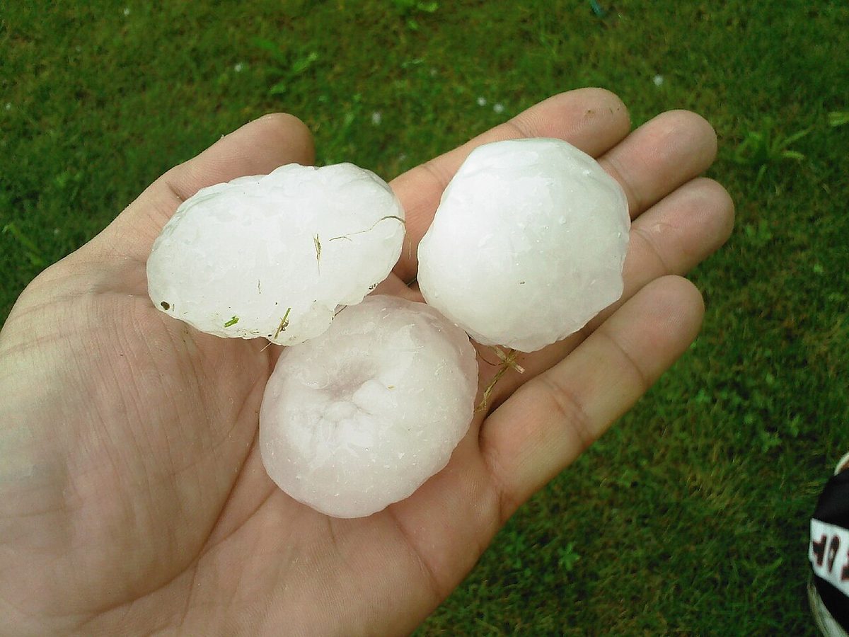
Ice pellets (PL) are small pellets of ice, most often raindrops that froze while falling through a layer of sub-zero air. Meeting them at the surface or during a descent means that liquid rain exists higher up, in a warmer layer above the cold one, and therefore that freezing rain lies above. A crew seeing ice pellets on the wing before an IFR departure should expect severe clear icing in the climb.
Sleet has no code of its own, and the word means different things either side of the Atlantic. In British usage it is rain and snow falling together, which a METAR reports as RASN or SNRA with the dominant type first. In American usage sleet means ice pellets, reported as PL.
Warning: ice pellets and freezing rain both mean an inversion with air warmer than 0 °C above sub-zero air. Rain falling at a negative outside air temperature is the same warning. Leave the area at once, usually by turning back.
Virga
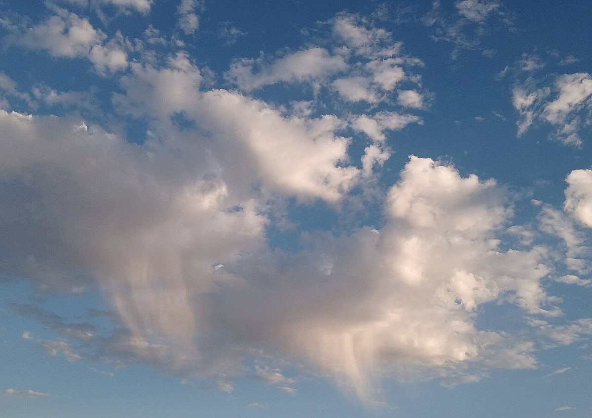
Virga is precipitation that evaporates before it reaches the ground, seen as grey streaks or trails hanging beneath the cloud base. It is typical of high-based cloud over dry air.
It matters because evaporation absorbs heat. The air in the shaft cools, becomes denser than its surroundings and sinks, and the downdraught accelerates. Beneath convective cloud this is the mechanism of the dry microburst, an intense, localised downdraught that reaches the ground with little or no rain. The FAA describes microbursts as usually less than 1 mile across, seldom lasting more than 15 minutes, with downdraughts of up to 6,000 ft/min. EASA exam material links them with summer air-mass thunderstorms at low latitudes over dry ground. In places such as Denver and Phoenix, crews treat virga under convective cloud near the aerodrome, especially with a ring of blowing dust beneath it, as a windshear warning (see windshear and microbursts). The shaft is also visible moisture, so an aircraft flying through it at sub-zero temperatures can collect ice.
Precipitation and cloud type
Each type of precipitation points to the cloud that produced it:
| Cloud | Typical precipitation | Character |
|---|---|---|
| Stratus | Drizzle or light rain; freezing drizzle when supercooled | Continuous or intermittent, light |
| Altostratus | Light rain or snow | Continuous |
| Nimbostratus | Moderate to heavy rain or snow; freezing rain in the cold air ahead of a warm front | Continuous, over a wide area |
| Cumulus | Rain or snow showers from larger clouds | Showers |
| Cumulonimbus | Heavy showers, hail, thunderstorms | Showers, often violent |
Read in reverse, the table becomes a forecasting tool. Hours of steady rain from a low, grey, featureless base mean nimbostratus and, usually, a front. Stop-start rain with bright intervals means convective cloud, and a heavy shower may conceal a cumulonimbus with hail and windshear. Drizzle with poor visibility means stratus in moist, stable air, with fog not far away.
Two limits apply. Airborne weather radar shows precipitation, not cloud: cloud droplets, dry snow and ice crystals return little or no echo, so a radar picture free of returns does not mean clear air. And automatic stations cannot always identify what is falling: ICAO reports then use UP, unknown precipitation, while US stations with a precipitation discriminator, marked AO2 in the remarks, can tell rain from snow.
Frequently asked questions
What is the Bergeron process in meteorology?
The Bergeron, or ice crystal, process is how precipitation forms in clouds colder than 0 °C. Below freezing the saturation vapour pressure over water is greater than over ice, so in a cloud holding both supercooled droplets and ice crystals, vapour deposits on the crystals while the droplets evaporate. The crystals grow, collect supercooled droplets and join into snowflakes, then fall as snow or, after melting in warmer air below, as rain.
What is the difference between continuous, intermittent and showery precipitation?
Continuous precipitation falls without a break for 60 minutes or more from layer cloud, above all nimbostratus, in stable air. Intermittent precipitation also comes from layer cloud but stops and starts without the cloud breaking. Showers fall from heap cloud, cumulus and cumulonimbus, in unstable air: they begin and end abruptly, change intensity quickly and are separated by brighter intervals, often with good visibility between them.
What is the difference between drizzle and rain?
Drizzle consists of fine, closely spaced drops smaller than 0.5 mm in diameter, falling from stratus. Rain has drops of 0.5 mm or more, up to about 5.5 mm, and comes from deeper cloud such as nimbostratus or, as showers, from cumulus and cumulonimbus. Drizzle falls gently but lowers visibility markedly, usually with low stratus and sometimes fog, and at sub-zero temperatures it becomes freezing drizzle.
What is sleet?
The word means different things in different countries. In British usage sleet is rain and snow falling together, which a METAR reports as RASN or SNRA. In American usage sleet means ice pellets, coded PL: raindrops that froze while falling through a layer of sub-zero air. Ice pellets matter to pilots because they show that liquid rain, and therefore freezing rain, exists in a warmer layer higher up.
Why is virga a warning sign for pilots?
Virga is precipitation that evaporates before it reaches the ground. Evaporation cools the air under the cloud, which becomes denser than its surroundings and sinks, so the downdraught accelerates. Beneath high-based convective cloud over dry ground this can produce a dry microburst, a violent downdraught with little or no rain at the surface. Virga near an aerodrome, especially with a ring of blowing dust beneath it, is treated as a windshear warning.
Which cloud produces hail?
Hail falls only from cumulonimbus. Its updraughts, which can reach 10,000 ft/min, carry frozen drops repeatedly through regions of supercooled water, where they grow by accretion until they are too heavy to be supported. Stones range from 5 mm to 50 mm or more across. Hail can be met anywhere in or below the cloud, damaging hail up to about 45,000 ft, and it can fall from the anvil into clear air miles from the core.
Test yourself on Precipitation
The v1prep banks cover this topic in Meteorology (050), with a worked explanation for every answer. EASA ATPL, PPL, IR and CPL, the FAA written tests and A320/B737 type ratings.
Start practising →Sources and further reading
- FAA-H-8083-28B, Aviation Weather Handbook
- WMO-No. 782, Aerodrome Reports and Forecasts, A Users' Handbook to the Codes
- Federal Meteorological Handbook No. 1 (FMH-1), Surface Weather Observations and Reports (2019)
- FAA Pilot's Handbook of Aeronautical Knowledge (FAA-H-8083-25), Chapter 12, Weather Theory
- FAA Aeronautical Information Manual, Chapter 7, Section 1 (Microbursts)
- FAA AC 91-74B, Pilot Guide, Flight in Icing Conditions
- American Meteorological Society, Glossary of Meteorology, Ice pellets
Library articles are written for study and exam preparation. They do not replace your aircraft's approved documentation, your operator's procedures or the regulations themselves.