Air Masses and Fronts
A front is the boundary zone between two air masses of different temperature and humidity. Where they meet, the warmer and lighter air is forced to rise over the colder air, producing the bands of cloud and precipitation, the wind shift and the pressure changes that pilots meet at frontal passage.
An air mass is a very large body of air, often covering much of an ocean or continent, whose temperature and humidity are broadly uniform in the horizontal. Where two air masses of different temperature meet they do not mix readily, and the boundary between them is a front: a sloping zone along which the warmer, less dense air is lifted over the colder air.
Fronts organise most of the bad weather of the middle latitudes. Their cloud, precipitation, icing and wind shifts decide destination ceilings, alternates and routes around embedded storms, and the frontal depression model underpins much of EASA ATPL meteorology and the weather questions of the FAA knowledge tests.
- Air mass source regions and classification
- Air mass weather and modification
- What a front is: slope and symbols
- Warm and cold fronts
- Ana-fronts and kata-fronts
- The frontal depression life cycle
- Occlusions and the triple point
- Weather changes at frontal passage
- Secondary depressions
- The Mediterranean front
- Frequently asked questions
Air mass source regions and classification
An air mass takes on its character over a source region, a large, uniform surface such as an ice cap, desert or ocean where air stagnates for days, usually under a slow-moving anticyclone, until its lower layers acquire the temperature and moisture of the surface. The subsiding air there is generally stable; once the air moves away, it starts to change.
Air mass classification uses two letters: A (arctic), P (polar) or T (tropical) for the source latitude, and c (continental, dry) or m (maritime, moist) for the surface. FAA practice puts the moisture letter first, giving polar maritime air (mP), tropical maritime air (mT) and tropical continental air (cT). British and many ATPL texts reverse the order: polar maritime air mass (Pm), tropical continental air mass (Tc). A third letter, k or w, sometimes shows whether the air is colder or warmer than the surface beneath it.
| Air mass | Source; arrives over north-west Europe from | Typical weather |
|---|---|---|
| Arctic maritime (mA, Am) | Arctic Ocean; north | Very cold; snow or hail showers, good visibility between them |
| Polar maritime (mP, Pm) | North Atlantic, Canada, Greenland; west or north-west | The most frequent over the British Isles; cumulus, showers, gusty wind, good visibility |
| Returning polar maritime (rPm) | Polar maritime air that has looped south; south-west | Between polar and tropical maritime; cloudy, sometimes showery |
| Tropical maritime air mass (mT) | Azores region; south-west | Mild and moist; stratus, drizzle, hill fog, sea fog in spring |
| Polar continental air mass (Pc) | Scandinavia and Russia; east, mainly in winter | Bitterly cold and dry; snow showers on east coasts after a sea crossing |
| Tropical continental (cT, Tc) | North Africa; south or south-east, mainly in summer | Hot, dry and hazy, sometimes with Saharan dust |
The Met Office counts six air masses for the British Isles because it separates returning polar maritime air; ATPL texts usually list five. FAA material uses the North American set: continental polar air from Canada, maritime tropical air from the Gulf of Mexico, maritime polar air off both oceans and continental tropical air from the south-western deserts.
Air mass weather and modification
Air moving over a warmer surface is heated from below, its lapse rate steepens and it becomes unstable: cumuliform cloud, showers, gusts, turbulence and good visibility outside precipitation. Air moving over a colder surface is cooled from below, an inversion forms and it becomes stable: layer cloud, drizzle, fog, smooth air and haze. A sea crossing adds moisture. Polar maritime air over a relatively warm Atlantic in winter is therefore showery and turbulent, while tropical maritime air over cooler water in spring brings sea fog and low stratus (see fog).
A polar air outbreak is a surge of cold polar or arctic air towards the equator, usually behind a vigorous cold front. It brings a sharp fall in temperature, strong winds and, over warmer sea, heavy showers and sometimes small, intense polar lows.
What a front is: slope and symbols
On a chart a front is drawn where the frontal surface meets the ground; above it the colder, denser air lies beneath the warm air as a shallow wedge. The frontal slope is typically about 1:150 for a warm front and 1:50 for a cold front, with a wide spread in practice. At 1:150 the frontal surface is only about 6,000 ft up at 150 NM ahead of the surface warm front, so a shallow front spreads its weather over a broad belt while a steep one packs it into a narrow, more violent band. Fronts lie in troughs of low pressure, and in the northern hemisphere the wind veers as one passes; in the southern hemisphere it backs.
The frontal types (warm, cold, occluded) are named after the air advancing at the surface. Colour charts show a warm front as a red line with semicircles, a cold front as a blue line with triangles and an occlusion as a purple line with both, the symbols pointing the way the front moves. A stationary front alternates red semicircles and blue triangles on opposite sides of the line.
The main frontal zone is the polar front, between polar and tropical air in the middle latitudes. It is broken into segments and waves, lies nearer the equator in winter than in summer, and runs beneath the polar front jet stream (see jet streams).
Warm and cold fronts
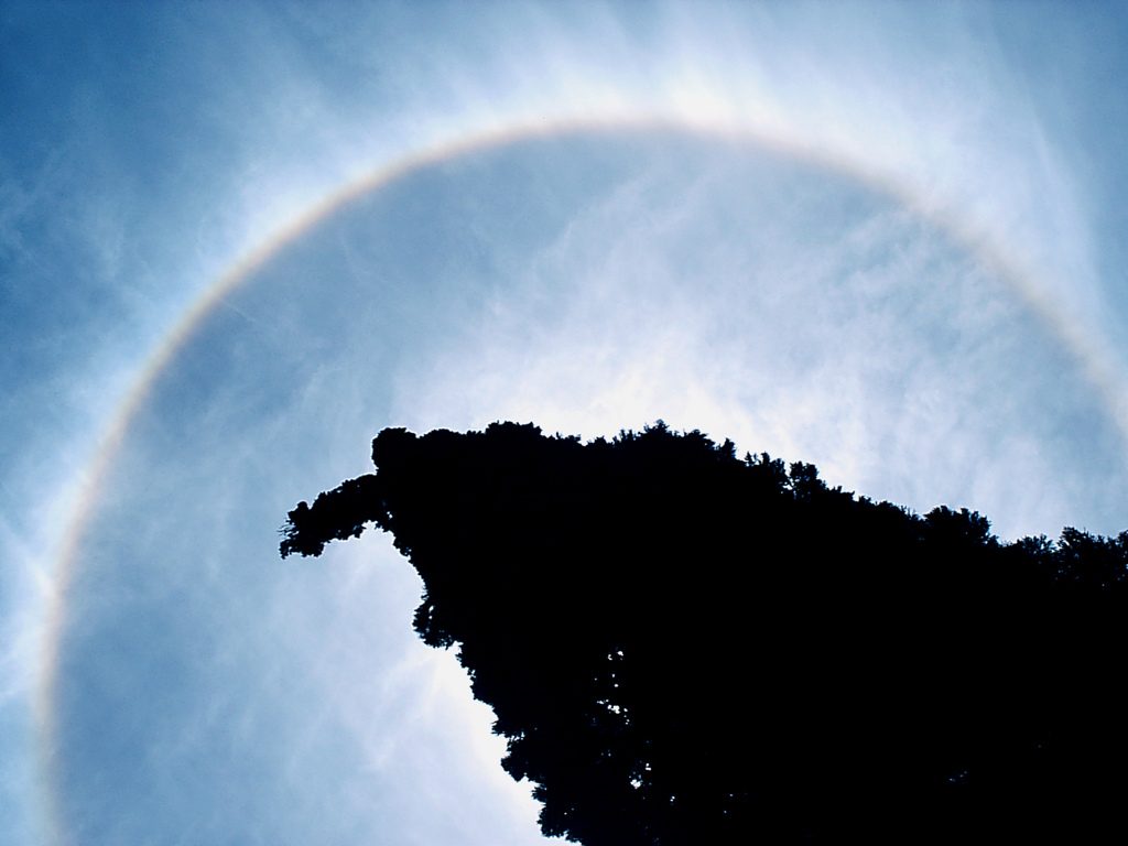
At a warm front the warm air slides up the shallow frontal surface. Ahead of it comes the classic cloud sequence: cirrus, then cirrostratus, often with a halo, then altostratus lowering and thickening into nimbostratus, with continuous rain or snow over a broad belt ahead of the surface front. Ceilings and visibility fall steadily, and rain saturating the cold air can form frontal fog.
Where the cold air under the frontal surface is below 0 °C and the warm air above is above 0 °C, rain falls into the cold layer, becomes supercooled and freezes on impact. This freezing rain, or rain ice, lies ahead of the surface warm front or a warm occlusion and can glaze an airframe within minutes (see airframe icing). If the rising warm air is unstable, cumulonimbus may be embedded in the layer cloud.
Behind the warm front lies the warm sector, usually tropical maritime air: a steady south-westerly wind in the northern hemisphere, steady temperature, low stratus or stratocumulus, drizzle, poor visibility and hill fog.
At a cold front the cold air undercuts the warm like a wedge. The steeper slope and stronger lifting give a narrow band of cumulus and cumulonimbus with heavy showers, thunderstorms, hail, turbulence, icing and low-level windshear, sometimes preceded by a squall line (see thunderstorms). Behind it the sky often clears quickly and showers develop in the colder, unstable air.
An ATPL rule of thumb is that a cold front moves at about the full geostrophic wind component at right angles to it and a warm front at about two-thirds of it, which is why cold fronts eventually overtake warm fronts.
Ana-fronts and kata-fronts
The ana-front / kata-front classification cuts across the warm and cold types and does not appear in the chart symbol.
- An ana-front is active: the warm air rises along the frontal surface through a great depth, giving deep cloud and heavy, prolonged precipitation. At an ana cold front the rain continues along and behind the surface front.
- A kata-front is weak: the warm air sinks relative to the frontal surface, often under subsidence from a nearby anticyclone, so an inversion caps the cloud at stratus and stratocumulus, with light rain or drizzle.
One front can be ana along part of its length and kata elsewhere; satellite, radar and the TAF sequence tell them apart.

The frontal depression life cycle
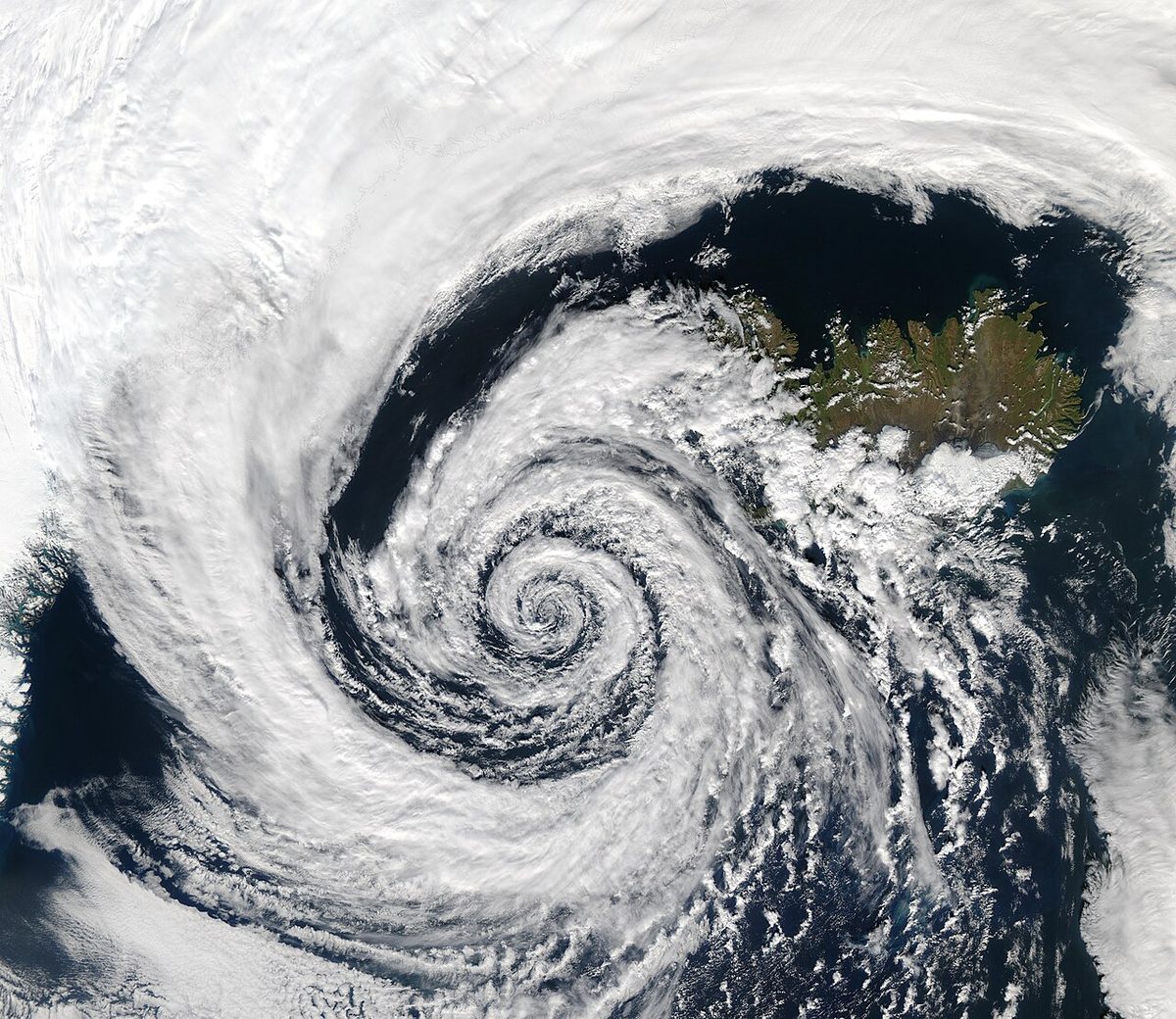
The polar front depression, or frontal depression, is described by the Norwegian cyclone model developed at Bergen around 1920. Cyclogenesis, the formation and deepening of a low, starts on the polar front, where polar and tropical air flow in opposite directions:
- A small wave forms on the front and pressure falls at its crest.
- The wave opens: a warm front ahead and a cold front behind enclose the warm sector, and a closed circulation develops.
- The faster cold front overtakes the warm front, starting near the centre, and the occlusion lengthens outwards.
- The low is usually at or near its deepest as occlusion begins, then fills as the warm air is lifted away from the surface.
While the warm sector is open, the depression tends to move in the direction of the warm-sector isobars. Depressions form in families along the polar front, a new member often developing on the trailing cold front of the last.
Occlusions and the triple point
An occluded front forms where the cold front has caught up with the warm front and lifted the warm-sector air off the surface. The point where the warm, cold and occluded fronts meet is the triple point, a favoured place for new lows to form.
The warm occlusion / cold occlusion distinction depends on which cold air mass is the colder:
- Warm occlusion. The air ahead of the warm front is colder than the air behind the cold front, so the overtaking air rides up over it and the occlusion behaves like a warm front, with most precipitation ahead. It is the usual winter type over western Europe, with cold continental air ahead, and brings a risk of freezing rain.
- Cold occlusion. The air behind is the colder. It undercuts both, and the occlusion behaves like a cold front; over western Europe it is more typical of summer.
The FAA uses the terms warm front occlusion and cold front occlusion for the same cases. In both, the main hazard is cumulonimbus embedded in nimbostratus, invisible from inside cloud without weather radar.
Exam tip: The colder of the two cold air masses stays at the surface. Colder air ahead gives a warm occlusion; colder air behind gives a cold occlusion.
As the depression matures, the occlusion may wrap round the centre and bend back behind it as a back-bent occlusion, bringing renewed cloud and precipitation, sometimes thundery, after the main fronts seem to have passed.
Weather changes at frontal passage
Frontal passage (FROPA) is the time a front crosses a station. FROPA is a US abbreviation used in forecasts and in the METAR remark WSHFT (wind shift) followed by the time and FROPA; ICAO METARs have no such remark. Typical changes at a northern hemisphere station on the equatorward side of the depression's track:
| Element | Warm front passage | Cold front passage |
|---|---|---|
| Pressure | Falls steadily ahead; the fall stops or slows behind | Falls ahead, then rises sharply |
| Wind | Backs and freshens ahead, veers at the front | Veers sharply, often with a squall |
| Temperature | Rises | Falls, often abruptly |
| Dew point | Rises | Falls |
| Cloud | Ci, Cs, As, then Ns lowering; St and Sc in the warm sector | Cu and Cb along the front, then clearing |
| Precipitation | Continuous, ahead of the front; drizzle behind | Heavy showers or thunderstorms at the front; showers later |
| Visibility | Poor in precipitation and in the warm sector | Poor in showers, otherwise good |
In flight, QNH falls towards a front and must be kept current, and flying from warm into cold air at a constant indicated altitude lowers the true altitude (see altimeter settings). The veer across a front changes the drift, and a cold front is best crossed at right angles to spend the least time in it.
Secondary depressions
A secondary depression is a smaller low within the circulation of a primary depression, usually forming at the triple point or as a wave on the trailing cold front. It moves cyclonically round the primary, anticlockwise in the northern hemisphere, and can deepen rapidly, sometimes becoming more vigorous than its parent, with gales where the two circulations reinforce each other.
The Mediterranean front
The Mediterranean front is a winter frontal zone between cold polar air over Europe and warm, dry tropical continental air from North Africa. Atlantic lows entering the basin, and lows forming over the Gulf of Genoa in the lee of the Alps, develop along it and bring much of the region's winter rain, thunderstorms and strong winds such as the mistral. In summer, under subtropical high pressure, it largely disappears.
Frequently asked questions
What is the difference between a warm front and a cold front?
At a warm front, warm air replaces cold air at the surface and rises gently up a shallow slope, typically around 1:150, giving a wide belt of layer cloud and continuous precipitation ahead of the front. At a cold front, cold air undercuts the warm air on a steeper slope, around 1:50, producing a narrow band of cumulonimbus, showers, gusts and turbulence, followed by clearer, colder air. Cold fronts usually move faster.
What weather changes happen when a cold front passes?
In the northern hemisphere the wind veers sharply, often with a squall, the temperature and dew point fall, and pressure, having fallen ahead of the front, starts to rise. Heavy showers or thunderstorms along the front give way to clearing skies, better visibility and scattered showers in the colder, unstable air behind. Pilots should expect turbulence, icing and low-level windshear in the frontal zone.
What is an occluded front?
An occluded front forms when the faster cold front of a frontal depression catches up with the warm front and lifts the warm-sector air off the ground. In a warm occlusion the air ahead is the colder, so the front behaves like a warm front; in a cold occlusion the air behind is the colder and it behaves like a cold front. Cumulonimbus embedded in nimbostratus is the main hazard.
What is the difference between an ana-front and a kata-front?
An ana-front is an active front where the warm air rises along the frontal surface, giving deep cloud and heavy, prolonged precipitation. A kata-front is a weak front where the warm air sinks relative to the frontal surface, usually beneath subsidence from high pressure, so an inversion limits the cloud to stratus and stratocumulus with light rain or drizzle. Both are drawn with the same chart symbol.
What does FROPA mean in aviation weather?
FROPA stands for frontal passage, the time a front crosses a station. It is a US abbreviation used in forecasts and in US METAR remarks, where a wind shift caused by a front is reported as WSHFT followed by the time and FROPA. ICAO METARs used under EASA rules have no such remark, so the passage has to be inferred from the change in wind, temperature, dew point and pressure.
Which air masses affect the weather in Europe?
ATPL texts list five. Arctic maritime air comes from the north, polar maritime from the north-west and tropical maritime from the south-west. Polar continental air arrives from the east, mainly in winter, and tropical continental air from North Africa, mainly in summer. The Met Office adds returning polar maritime air, which loops south over the Atlantic before arriving from the south-west. Polar maritime air is the most frequent over the British Isles.
Test yourself on Air Masses and Fronts
The v1prep banks cover this topic in Meteorology (050), with a worked explanation for every answer. EASA ATPL, PPL, IR and CPL, the FAA written tests and A320/B737 type ratings.
Start practising →Sources and further reading
- FAA-H-8083-28B, Aviation Weather Handbook (chapter on air masses, fronts and the wave cyclone model)
- Royal Meteorological Society MetLink, Air Masses (in depth)
- R. Stull, Practical Meteorology, Chapter 12, Fronts and Airmasses (University of British Columbia, via LibreTexts)
- Encyclopaedia Britannica, Warm front
- Flaounas et al. (2022), Mediterranean cyclones, Weather and Climate Dynamics 3, 173–208
Library articles are written for study and exam preparation. They do not replace your aircraft's approved documentation, your operator's procedures or the regulations themselves.