Altimeter Settings, Altitude and Height
An altimeter setting is the reference pressure set on a barometric altimeter's subscale. It decides whether the instrument shows altitude above mean sea level (QNH), height above an aerodrome (QFE) or a flight level based on the 1013.25 hPa standard pressure.
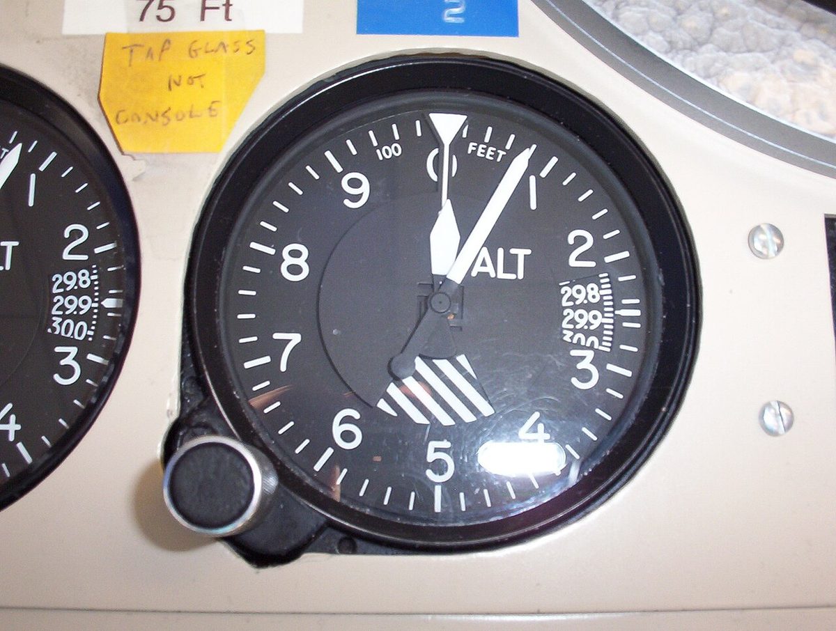
A pressure altimeter does not measure distance. It measures static pressure, delivered by the pitot-static system, and converts it into a vertical position using the pressure and height relationship of the International Standard Atmosphere (ISA). What the pilot reads therefore depends on the reference pressure dialled into the subscale, the altimeter setting. One value makes the pointer show height above the runway, another shows altitude above the sea, and the standard value shows a flight level that has no fixed geometric meaning at all.
Choosing the right datum at the right moment underpins terrain clearance, vertical separation between aircraft and every approach minimum on the chart. A wrong setting, a missed change at the transition altitude or an ignored cold day has each contributed to level busts and to controlled flight into terrain. This article sets out the vocabulary and procedures that EASA and FAA theory examinations test.
Altitude, height and elevation
ICAO keeps separate words for vertical distance and uses them strictly:
- Altitude is the vertical distance of a level, point or object measured from mean sea level (MSL). Altitudes are therefore above mean sea level (AMSL); FAA publications simply write MSL.
- Height is vertical distance from a specified datum, which must be stated: above ground level (AGL) over open country, or above aerodrome level (AAL) in the circuit and on approach. The FAA equivalent of AAL is above field elevation (AFE).
- Elevation is the vertical distance above MSL of a point on, or fixed to, the Earth's surface: a summit, a mast, a runway threshold.
A flight level (FL) is not a distance at all. It is a surface of constant pressure related to the 1013.2 hPa datum and labelled in hundreds of feet of standard-atmosphere altitude, so FL 100 is where the pressure equals what ISA predicts at 10,000 ft. Radiotelephony keeps the words apart: "altitude 3,000 feet", "height 1,500 feet", "flight level 70".
FAA material adds names for what an altimeter can be said to show: indicated altitude (the reading with the current setting), true altitude (actual height above MSL), absolute altitude (height above the surface below, measured by a radio altimeter), pressure altitude and density altitude.
QNH, QFE and QNE
The Q-codes survive from the days of Morse and remain the common language:
| Setting | What it is | Reads on the ground | Reads in flight |
|---|---|---|---|
| QNH | Aerodrome pressure reduced to MSL using ISA | Aerodrome elevation | Altitude AMSL |
| QFE | Pressure at aerodrome (or threshold) elevation | Zero | Height above the aerodrome |
| Standard, 1013.25 hPa / 29.92 inHg | Fixed datum | Aerodrome pressure altitude (QNE) | Pressure altitude, flight level |
Strictly, QNE is not a pressure but the altimeter reading in feet on the runway with 1013.2 hPa set, in other words the aerodrome's pressure altitude; in everyday speech it is used loosely for the standard setting itself. QNH also differs from QFF, the meteorologist's sea-level pressure, which is reduced using actual rather than standard temperature.
QNH is the normal setting for take-off, landing and flight below the transition altitude, because chart elevations and procedure altitudes are published above MSL. QFE is still used by some operators and military units for circuit flying. QNH and QFE are rounded down to the whole hectopascal, which errs towards the aircraft being higher than indicated. Where an instrument runway's threshold is 7 ft (2 m) or more below aerodrome elevation, a threshold QFE may be issued.
In the United States the term QNH is rarely heard: ATC issues the altimeter setting in inches of mercury, which is the local QNH. Most other states use hectopascals. On glass flight decks the barometric altimeter setting (BARO) is shown beside the altitude tape and selected on the EFIS control panel; pressing STD selects standard pressure and the display then reads STD instead of a number.
Warning: 29.92 inHg and 992 hPa sound alike on the radio but are about 21 hPa apart, close to 600 ft of altimeter error. Always read back the unit with the value.
Exam tip: near sea level 1 hPa is worth about 27 to 30 ft and 1 inHg about 1,000 ft. The height per hectopascal grows as the air thins, to roughly 50 ft at FL 200 and about 100 ft near FL 400.
Standard setting and flight levels
The standard pressure setting (SPS) is 1013.25 hPa (29.92 inHg), the ISA sea-level pressure, usually rounded to 1013 on the subscale. With it set the altimeter shows pressure altitude, the height in the standard atmosphere at which the measured pressure would occur. Because every aircraft above the transition altitude shares the datum, a 1,000 ft difference in flight level gives about 1,000 ft of real separation whatever the local sea-level pressure. The transponder's altitude report is always pressure altitude referenced to 1013.25 hPa, whatever the pilot has set.
Cruising levels follow the semicircular rule. Under SERA Appendix 3, magnetic tracks 000° to 179° take odd thousands of feet (FL 50, FL 70 and, in RVSM airspace, FL 290 to FL 410 in steps of 2,000 ft), tracks 180° to 359° even thousands, and VFR flights add 500 ft. The UK replaced its quadrantal rule with this system on 2 April 2015. The FAA rule (14 CFR 91.179 for IFR, 91.159 for VFR more than 3,000 ft AGL) is built the same way but refers to magnetic course rather than track.
Transition altitude, level and layer
The transition altitude (TA) is the altitude at or below which vertical position is controlled by reference to altitudes on QNH. The transition level (TL) is the lowest flight level available for use above the transition altitude. The airspace between them is the transition layer.

PANS-OPS asks states to set the transition altitude as low as possible but normally not less than 3,000 ft above the aerodrome. Because the transition level is a pressure surface, its true height falls when QNH falls, so air traffic services derive it from the current QNH and pass it on the ATIS or in the approach clearance. In the ICAO European region the transition level must lie at least 1,000 ft above the transition altitude, so aircraft at each are separated; the layer is therefore 1,000 ft deep or more, depending on pressure.
- Climbing: set standard on passing the transition altitude and report flight levels.
- Descending: set QNH on passing the transition level and report altitudes.
- Within the layer: vertical position is expressed as a flight level when climbing and as an altitude when descending. Nobody cruises in the layer.
Europe has no single transition altitude. Most states use values between 3,000 and 6,000 ft; Germany uses 5,000 ft, and the UK is generally 3,000 ft with higher figures, commonly 5,000 or 6,000 ft, beneath some terminal areas. A single harmonised European transition altitude, with 18,000 ft among the options, has been studied for years without agreement, and the UK and Ireland have long-standing plans to raise theirs. The chart and AIP are the only reliable reference.
The United States uses a transition altitude of 18,000 ft MSL. Under 14 CFR 91.121, 29.92 inHg is set at and above it, and the lowest usable flight level rises when pressure is low: FL 180 with a setting of 29.92 or higher, FL 185 for 29.91 to 29.42, FL 190 for 29.41 to 28.92, and so on.
Regional QNH and remote altimeter settings
Below the transition altitude but away from an aerodrome, a pilot still needs a sea-level datum. In the UK this is the Regional Pressure Setting, taught as the forecast regional QNH or simply regional QNH: the lowest QNH forecast for each Altimeter Setting Region, issued every hour. Using the lowest value means the altimeter under-reads, so the aircraft is at or above its indicated altitude.
The FAA requires, below 18,000 ft MSL, the current reported setting of a station along the route and within 100 NM of the aircraft. Where an airport has no local source, the approach chart may name a remote altimeter setting source and raise the minimums when it is used; a typical note reads "when local altimeter setting not received, use (named station) altimeter setting and increase all MDA 60 feet". The increase depends on distance and elevation difference.
Pressure, temperature and true altitude
True altitude equals indicated altitude only in ISA conditions with the correct QNH set. Two errors separate them.
Pressure error. Flying towards lower pressure without resetting, the aircraft follows the descending pressure surfaces and the altimeter over-reads: "high to low, look out below". An aircraft flown from a 30.12 inHg area to a 29.62 area without resetting is about 500 ft lower than indicated. Any setting higher than the actual QNH has the same effect: at an aerodrome 1,240 ft high with QNH 1008, an altimeter left on 1013 reads about 1,375 ft.
Temperature error. Cold air is dense, so pressure falls with height faster than ISA assumes and the altimeter over-reads; warm air produces an under-read. PANS-OPS gives a rule of thumb of 4 per cent of height above the altimeter setting source for every 10 °C below standard, about 4 ft per 1,000 ft per degree, with tables for colder conditions. At 3,000 ft above the source on an ISA −20 °C day the aircraft is about 240 ft low. Pilots add cold-temperature corrections to procedure altitudes and tell ATC; the FAA publishes Cold Temperature Airports, marked with a snowflake and a temperature on the chart. See cold-weather altimetry for the method.
Density altitude, pressure altitude corrected for non-standard temperature, governs engine and wing performance, not separation.
GNSS geometric altitude
A satellite receiver computes height above the WGS-84 ellipsoid and converts it to MSL with a geoid model. The result, GNSS geometric altitude or GPS altitude, is a geometric altitude: a true distance, unaffected by pressure or temperature. The ellipsoid and geoid differ by about −105 m to +85 m around the world, so the model matters.
GPS altitude does not replace the barometric altimeter. Separation and published procedure altitudes are barometric, so on a cold day, or when flying a flight level, the two displays may legitimately disagree by hundreds of feet. ADS-B reports both pressure altitude and geometric height. SBAS approaches with LPV minima define the final approach geometrically and are immune to temperature error, whereas baro-VNAV approaches carry published temperature limits. Terrain warning computers blend GPS, barometric and radio data into their own geometric altitude to guard against mis-sets and cold weather (see GPWS and TAWS).
Aerodrome elevation and reference points
- Aerodrome elevation (ICAO) is the elevation of the highest point of the landing area. The FAA's field elevation, or airport elevation, is the highest point of an airport's usable runways, in feet MSL.
- The aerodrome reference point (ARP) is the aerodrome's designated geographical location, placed near its geometric centre.
- Threshold elevation is the elevation of the landing threshold. Obstacle clearance heights for precision approaches are referenced to it. For non-precision approaches the reference is aerodrome elevation, or the threshold if it lies more than 2 m (7 ft) lower, and circling uses aerodrome elevation.
- Touchdown zone elevation (TDZE) is, in FAA usage, the highest elevation in the first 3,000 ft of the landing surface. US charts give straight-in minimums as height above touchdown (HAT) and circling minimums as height above airport (HAA).
Before flight the altimeter, set to QNH, should read the known elevation of the check point. PANS-OPS tolerances are ±60 ft for instruments tested to 30,000 ft and ±80 ft for those tested to 50,000 ft; the FAA's Instrument Flying Handbook uses 75 ft for IFR flight.
Exam tip: minimum safe altitudes, decision altitudes and minimum descent altitudes are AMSL and flown on QNH; decision heights and obstacle clearance heights are heights above the threshold or the aerodrome elevation.
Frequently asked questions
What is the difference between QNH and QFE?
QNH is the aerodrome pressure reduced to mean sea level using the standard atmosphere, so an altimeter set to it reads the aerodrome elevation on the ground and altitude above sea level in flight. QFE is the actual pressure at aerodrome or threshold level, so the altimeter reads zero on the runway and height above the aerodrome in the air. Charted minimum altitudes are published against QNH.
What is the transition altitude in Europe and in the United States?
In the United States the transition altitude is 18,000 ft MSL everywhere and 29.92 inHg is set at and above it. Europe has no single value. Most states use figures between 3,000 and 6,000 ft, Germany uses 5,000 ft, and the UK is generally 3,000 ft with higher values under some terminal areas. Proposals to harmonise at a higher common value have not produced one European figure, so pilots must read it from the chart.
Why is the transition level not the same every day?
A flight level is a pressure surface, so its true height moves with the sea-level pressure. On a low-pressure day a given flight level lies closer to the ground and may no longer clear the transition altitude by a safe margin. Air traffic services therefore work out the lowest usable flight level from the current QNH and publish it on the ATIS or in the approach clearance.
What does "high to low, look out below" mean?
It is the memory aid for altimeter errors. Flying from high pressure towards low pressure without updating the setting, or from warm air into colder air, makes the altimeter over-read, so the aircraft is lower than the instrument shows. About 27 ft of error arises for each hectopascal of pressure change near sea level, and roughly 4 per cent of height for every 10 °C colder than standard.
Is GPS altitude the same as altimeter altitude?
No. GPS altitude is a geometric measurement of height above the WGS-84 ellipsoid, converted to mean sea level with a geoid model, and it is not affected by pressure or temperature. The barometric altimeter infers altitude from pressure and so carries pressure and temperature errors. Air traffic separation and published procedure altitudes use barometric altitude, which is why the two readings often differ by hundreds of feet.
Test yourself on Altimeter Settings, Altitude and Height
The v1prep banks cover this topic in Instrumentation (022), with a worked explanation for every answer. EASA ATPL, PPL, IR and CPL, the FAA written tests and A320/B737 type ratings.
Start practising →Sources and further reading
- ICAO Doc 8168, Procedures for Air Navigation Services, Aircraft Operations (PANS-OPS), and related Annexes
- FAA Aeronautical Information Manual, Chapter 7 Section 2, Barometric Altimeter Errors and Setting Procedures
- 14 CFR 91.121, Altimeter settings
- FAA AIP ENR 1.8, Cold Temperature Barometric Altimeter Errors, Setting Procedures and Cold Temperature Airports
- UK AIP ENR 1.7, Altimeter Setting Procedures (NATS)
- EASA A-NPA 2012-01, Harmonised European Transition Altitude
- FAA Pilot/Controller Glossary (touchdown zone elevation and related terms)
Library articles are written for study and exam preparation. They do not replace your aircraft's approved documentation, your operator's procedures or the regulations themselves.