Turbulence
Turbulence is irregular, rapidly changing motion of the air, made up of eddies of many sizes, that jolts an aircraft and disturbs its attitude, altitude and airspeed. It is generated by friction with the ground, convection, wind shear, mountain waves and the wakes of other aircraft.
Turbulence is irregular, rapidly fluctuating motion of the air: eddies of many sizes superimposed on the mean wind. An aircraft flying through them is jolted, its attitude and altitude disturbed and its airspeed made to fluctuate.
Turbulence rarely threatens the structure of a modern airliner flown at the right speed, but it is a leading cause of injuries in airline flying. The US National Transportation Safety Board (NTSB) found that turbulence-related accidents made up more than a third of all Part 121 air carrier accidents from 2009 to 2018, and that flight attendants were the people most often seriously injured.
Causes of turbulence
Something must stir the air into eddies. The main sources are:
- friction between the wind and the ground, which produces mechanical turbulence;
- convection from a heated surface, which produces thermal turbulence;
- lifting and shear at fronts and in convective cloud;
- standing waves in the lee of high ground;
- wind shear in clear air, especially near jet streams and the tropopause;
- the wake vortices of other aircraft, a subject with its own separation rules (see wake turbulence and jet blast).
What matters to the pilot is where each kind lives, what cloud, if any, marks it, and how deep it reaches.

Mechanical turbulence
Mechanical turbulence forms when the wind blows over rough ground, trees, hills and buildings. It is confined to the friction layer, the lowest few thousand feet, and grows in strength and depth with wind speed, surface roughness and instability. Stable air damps it and a low inversion caps it. With enough moisture, mixing below the inversion produces a flat-topped sheet of stratus or stratocumulus, sometimes called turbulence cloud.
At aerodromes, hangars, buildings and nearby hills shed eddies and gusts downwind that can upset an aircraft on short final or in the flare. A gust group (G) in the METAR wind is the clue, and many operators add a gust allowance to the approach speed. Strong surface winds also bring the low-level windshear covered in windshear and microbursts.
Thermal turbulence
Thermal turbulence, or convective turbulence, comes from thermals rising over an unevenly heated surface and the air sinking between them. Over land it follows the sun: weak in the morning, strongest in the early to mid afternoon on clear, sunny days, and fading in the evening. Dry ground, rock and towns heat faster than water, woods or wet fields, so an aircraft on approach meets alternating lift and sink. The turbulence reaches the top of the convective layer, usually marked by cumulus tops or a haze layer under an inversion; above it the air is generally smooth.
Over the sea, whose surface temperature hardly changes through the day, there is little daytime convection. It comes instead from cold air moving over warmer water, as in polar maritime air in winter, and continues by night. When convection builds cumulonimbus the turbulence becomes severe or extreme (see thunderstorms).
Frontal turbulence
At a front, warm air is lifted and the wind changes speed and direction across a narrow zone. Turbulence at a slow warm front is usually light unless cumulonimbus is embedded in the layer cloud. At an active cold front, especially a fast-moving one, it can be moderate or severe in the cumulus and cumulonimbus along the front and in the wind shift near the surface (see fronts).
Mountain waves, rotor and lenticular cloud
When a strong wind crosses a ridge in stable air, the displaced air oscillates downwind as a train of mountain waves, also called standing or lee waves, which stay almost fixed over the ground. The classic ATPL recipe is a wind within about 30° of perpendicular to the ridge, at least about 15 kt at summit level and increasing with height, with a stable layer near the summits. The waves can extend far downwind and well above the ridge, sometimes into the stratosphere.
When the air is moist, three clouds mark them:
- A cap cloud sits on the ridge, forming on the windward side and spilling down the lee slope, where it evaporates.
- Lenticular cloud (altocumulus lenticularis, reported as ACSL in US METAR remarks) forms in the wave crests: smooth, lens-shaped, sometimes stacked, and stationary while the wind blows through it.
- Roll cloud, or rotor cloud, forms in the rotor beneath a crest, usually at or below ridge height.
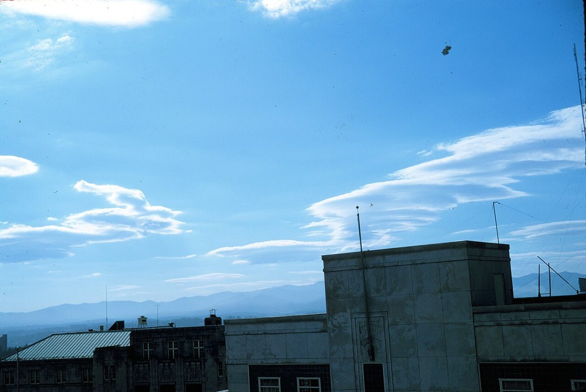
The smooth wave hides real hazards. Wave downdraughts can exceed a light aircraft's climb performance, and the rotors, strongest beneath the first crest downwind of the ridge, can hold severe or extreme turbulence close to the ground. When the low-level wind is strong but falls off with height, rotors can break away and travel downwind, which ATPL texts call rotor streaming. At cruise levels, waves over high ranges cause turbulence and altitude excursions. A SIGMET is issued for severe mountain wave (SEV MTW); see mountain waves.
Clear air turbulence and the jet stream
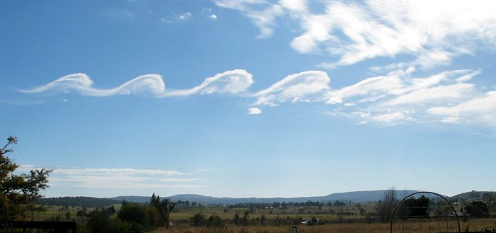
Clear air turbulence (CAT) is turbulence outside cloud, usually at high level, with no visual warning. Airborne weather radar sees only precipitation and cannot detect it. The AIM asks pilots to report high-level turbulence, normally above 15,000 ft, that is not associated with cumuliform cloud as CAT. Its main cause is wind shear, which makes layers of air slide over one another until they break into waves and eddies: the Kelvin-Helmholtz instability, occasionally made visible as billow cloud.
The strongest shear surrounds jet streams, narrow ribbons of strong wind near the tropopause. The WMO sets the lower limit for a jet stream at 30 m/s, about 60 kt, the figure used in ATPL syllabi; the main ones are the polar front jet and the higher subtropical jet (see jet streams). CAT is most likely:
- on the cold, low-pressure (polar) side of the jet core, near or just below the axis;
- above the core, around the sloping tropopause;
- in sharp upper troughs, where the flow curves tightly, more than at broad ridges.
The FAA's cancelled circular AC 00-30C treated jets with a core speed above about 110 kt as the ones likely to have significant turbulence, and older FAA guidance advised avoiding areas where vertical shear exceeds 6 kt per 1,000 ft or horizontal shear 40 kt per 150 miles. CAT patches tend to be long in the direction of the wind but shallow, so a change of level is often the quickest way out.
Exam tip: Near a jet stream, expect CAT on the cold (low-pressure) side just below the core. Upper troughs are rougher than ridges because the flow curves more sharply.
Turbulence intensity and reporting
Turbulence intensity is judged by its effect on the aircraft and its occupants. The turbulence intensity scale used by ICAO has three grades: light, moderate and severe. The FAA's AIM adds a fourth, extreme, and a separate description, chop: rapid, somewhat rhythmic bumpiness without appreciable change in altitude or attitude, reported as light or moderate chop.
| Intensity | Aircraft reaction (AIM) | Inside the aircraft (AIM) | ICAO accelerometer guide |
|---|---|---|---|
| Light | Slight, erratic changes in attitude or altitude | Slight strain against belts; loose objects may shift slightly | Less than moderate |
| Moderate | Changes in attitude or altitude, but always in positive control; usually airspeed variations | Definite strain against belts; loose objects dislodged; walking and food service difficult | 0.5 to 1.0 g at the centre of gravity |
| Severe turbulence | Large, abrupt changes in attitude and altitude; large airspeed variations; may be momentarily out of control | Occupants forced violently against belts; objects tossed about; walking and food service impossible | More than 1.0 g |
| Extreme (AIM only) | Violently tossed about, practically impossible to control; may cause structural damage | Not described | Not used |
The AIM qualifies duration as occasional (less than a third of the time), intermittent (a third to two-thirds) or continuous (more than two-thirds).
ICAO and the WMO also use an aircraft-independent measure, the eddy dissipation rate (EDR): the cube root of the rate at which turbulent kinetic energy is dissipated, with values from 0 in smooth air up to about 1. ICAO Annex 3 specifies EDR for automated turbulence reports, calculated by software from the aircraft's own data, and gridded forecasts such as GTG use the same scale. The same EDR is felt as lighter in a heavy jet than in a light aircraft.
Pilot reports warn those behind. In the United States a pilot report (PIREP) carries turbulence in its TB field; it is coded UA, or UUA as an urgent report for severe or extreme turbulence, including CAT. The AIM asks for location, time, intensity, whether in or near cloud, altitude, aircraft type and duration. Under ICAO rules, which EASA applies through the Standardised European Rules of the Air, a pilot makes a special air-report (AIREP SPECIAL) on meeting moderate or severe turbulence, severe mountain wave and other listed hazards, so that the meteorological office can issue or amend a SIGMET.
Turbulence forecasts and guidance products
- SIGMET and AIRMET. ICAO SIGMETs warn of severe turbulence (SEV TURB) and severe mountain wave (SEV MTW). Turbulence in convective cloud is covered by the thunderstorm SIGMET, not by SEV TURB. AIRMETs cover moderate turbulence (MOD TURB) and moderate mountain wave (MOD MTW) for low-level flights. In the United States a non-convective SIGMET covers severe or extreme turbulence not associated with thunderstorms, and AIRMET Tango, issued graphically as G-AIRMET, covers moderate turbulence, sustained surface winds of 30 kt or more and non-convective low-level windshear.
- Significant weather charts. WAFS high-level SIGWX charts show jet streams and areas of moderate or severe CAT, bounded by a dashed line and labelled with a boxed number that refers to a legend giving the intensity and vertical extent.
- Gridded guidance. The US Graphical Turbulence Guidance (GTG), developed by NCAR and shown on aviationweather.gov, forecasts turbulence as EDR by flight level, with separate clear air, mountain wave and convectively induced components. A nowcast version updates every 15 minutes over the contiguous United States. The World Area Forecast System provides global gridded turbulence forecasts.
Flying in turbulence
Planning avoids much of it: check SIGMETs, charts and gridded forecasts, ask for ride reports, and choose levels and routes away from the jet core, the lee of high ground and convective cloud. Switch the seat belt sign on before expected turbulence, not after it starts.
Speed. Slowing down reduces the load a given gust imposes. In a light aeroplane, fly at or below the design manoeuvring speed, VA, at which a sharp gust or full deflection of one control stalls the wing before the limit load factor is reached. VA falls with weight, roughly with the square root of mass, so 20 % below maximum weight it is about 10 % lower. Full, abrupt inputs or reversals can still overstress an aircraft below VA, a point the FAA stressed after the loss of American Airlines Flight 587 in 2001.
Transport aeroplanes publish a turbulence penetration speed. Under 14 CFR 25.1517, mirrored by EASA CS 25.1517, the rough air speed VRA must be far enough below VMO that speed excursions in rough air will not set off the overspeed warning too often; without an analysis supporting another value, it must be less than VMO minus 35 KTAS. At altitudes where VMO is limited by Mach number, VRA may be chosen to give the best margin between low-speed and high-speed buffet, and many types publish it as a Mach number, MRA. That margin shrinks with altitude, so in severe turbulence a descent widens it (see high-speed flight).
Technique.
- Set the penetration speed, or the attitude and thrust given in the aircraft's procedures.
- Fly attitude, not altitude: keep the wings level, hold the pitch attitude and accept deviations in altitude and airspeed. Chasing them adds manoeuvre loads to the gust loads.
- Use small, smooth control inputs and avoid large rudder inputs.
- Follow the type's guidance on autopilot and autothrust. The AIM's thunderstorm penetration advice is to disengage altitude-hold and speed-hold modes, which would otherwise chase the gusts.
- Tell ATC if the assigned level cannot be held, and report the turbulence.
If an upset develops, recover as described in upset prevention and recovery. After a severe encounter, record it in the technical log, since it normally triggers a structural inspection.
Cabin safety
People who are not strapped in are the ones hurt. CAT gives little or no warning, so passengers are advised to keep their belts fastened whenever seated, and crews secure the cabin early, stop the service and sit down themselves when moderate or severe turbulence is expected. Flight attendants are most at risk because they are standing and working when an encounter starts; an early warning from the flight deck and accurate reports from aircraft ahead are their best protection.
Warning: Large or reversing control inputs, especially on the rudder, can exceed structural limits even below VA.
Frequently asked questions
What are the levels of turbulence intensity?
ICAO grades turbulence as light, moderate or severe, and the FAA AIM adds extreme. Light turbulence causes slight, erratic changes in attitude or altitude. Moderate brings definite strain against seat belts and airspeed variations, but the aircraft stays in positive control. Severe causes large, abrupt changes, throws occupants violently against their belts and may leave the aircraft momentarily out of control. Extreme tosses the aircraft about violently and may damage it.
What causes clear air turbulence?
Clear air turbulence is caused mainly by strong wind shear in cloud-free air, which makes layers of air break into waves and eddies. It is most common near jet streams, especially on the cold, low-pressure side just below the core, near the tropopause, in sharply curved upper troughs and in mountain waves reaching high levels. Weather radar cannot detect it, so pilots rely on forecasts and reports from other aircraft.
What speed should you fly in turbulence?
Slow to the turbulence penetration speed published for the type. In a light aeroplane that means at or below the design manoeuvring speed VA, which falls as weight decreases. Transport aeroplanes publish a rough air speed VRA and Mach MRA, set below VMO and MMO to avoid overspeed and, at high altitude, to balance the margins to low-speed and high-speed buffet. Then hold attitude and accept altitude changes.
What is the difference between turbulence and chop?
In the FAA AIM, chop is rapid, somewhat rhythmic bumpiness without appreciable changes in altitude or attitude, reported as light or moderate chop. Turbulence, by contrast, produces changes in altitude or attitude, from slight and erratic in light turbulence to large and abrupt in severe turbulence. ICAO reporting does not use the term chop; it grades turbulence as light, moderate or severe.
What is EDR in turbulence reporting?
EDR, the eddy dissipation rate, is the ICAO and WMO standard measure of turbulence. It is the cube root of the rate at which turbulent energy is dissipated, calculated automatically from aircraft data and reported without pilot action. Because it describes the air rather than the aircraft, the same EDR value feels rougher in a small, light aeroplane than in a heavy jet. Forecasts such as GTG are issued in EDR.
Can turbulence make a plane crash?
Turbulence rarely threatens the structure of a modern airliner flown at the correct speed. The real risk is injury. The NTSB found that turbulence accounted for more than a third of US Part 121 airline accidents between 2009 and 2018, and flight attendants were the people most often seriously hurt. For light aircraft, severe rotor and mountain wave turbulence close to the ground is the greater danger.
Test yourself on Turbulence
The v1prep banks cover this topic in Meteorology (050), with a worked explanation for every answer. EASA ATPL, PPL, IR and CPL, the FAA written tests and A320/B737 type ratings.
Start practising →Sources and further reading
- FAA Aeronautical Information Manual, Chapter 7, Section 1 (PIREPs relating to turbulence, clear air turbulence)
- FAA Aeronautical Information Manual, Chapter 7, Section 6 (Potential flight hazards, mountain flying)
- WMO, Aviation hazards, turbulence and wind shear
- 14 CFR 25.1517, Rough air speed, VRA
- FAA Advisory Circular AC 00-30C, Clear Air Turbulence Avoidance (cancelled)
- NTSB Safety Research Report SS-21/01, Preventing Turbulence-Related Injuries in Air Carrier Operations
- NCAR Research Applications Laboratory, Graphical Turbulence Guidance (GTG)
- ICAO EUR Doc 014, EUR SIGMET and AIRMET Guide
Library articles are written for study and exam preparation. They do not replace your aircraft's approved documentation, your operator's procedures or the regulations themselves.