Windshear and Microbursts
Windshear is a change in wind speed or direction, or both, over a short distance, including updraughts and downdraughts. Near the ground, above all in a microburst beneath a convective cloud, it can change an aeroplane's airspeed and flight path faster than its performance can recover them.
Windshear, written wind shear in ICAO documents, is a change in wind speed, direction or both over a short distance, horizontally or vertically, including the vertical currents of updraughts and downdraughts. At altitude it mostly shows itself as turbulence. Close to the ground it can change an aeroplane's airspeed faster than the engines can restore it, at a height where there is nothing left to trade for speed.
The most violent form is the microburst, a small, intense downdraught beneath a convective cloud that spreads out in all directions when it reaches the ground. NASA counted more than 26 windshear accidents and incidents involving major US civil transports between 1964 and 1985, with over 600 deaths. The response that followed, combining pilot training, ground-based detection and airborne warning systems, worked: windshear has almost disappeared as a cause of major airline accidents.
- What windshear is
- Horizontal and vertical windshear
- Performance-increasing and performance-decreasing windshear
- Causes of low-level windshear
- Microbursts and downbursts
- Wet and dry microbursts
- Detection: LLWAS, TDWR and warnings
- Recognition and recovery
- Accidents that shaped the defences
- Frequently asked questions
What windshear is
ICAO's windshear manual, Doc 9817, takes the broadest view: any change in wind speed or direction in space, updraughts and downdraughts included. The operational concern is low-level wind shear (LLWS), the shear met along the final approach, on the runway and along the take-off and initial climb path. ICAO treats this layer as extending from runway level to 500 m (1,600 ft), the height band that aerodrome warnings cover. The FAA uses LLWS for shear within 2,000 ft of the surface, and its airline equipment rule (14 CFR 121.358) speaks of low-altitude windshear.
Doc 9817 grades vertical shear by its rate: light up to 4 kt per 100 ft, moderate 5 to 8 kt, strong 9 to 12 kt and severe above 12 kt per 100 ft.
Horizontal and vertical windshear
Vertical windshear is the change of the wind vector with height, for example when climbing through a temperature inversion with a strong wind above it. It is usually quoted in knots per 100 ft. Horizontal windshear is the change of the wind vector with horizontal distance, as when crossing a front, a gust front or a microburst; ATPL texts quote it in knots per 1,000 ft. Updraughts and downdraughts are a third component. An aeroplane on a 3° approach meets all of them at once, descending through the vertical profile while moving across the horizontal one.
Exam tip: Vertical shear is change with height; horizontal shear is change with horizontal distance. The direction of change says nothing about the danger: that depends on whether the shear adds or removes energy.
Performance-increasing and performance-decreasing windshear
An aeroplane's inertia keeps its groundspeed almost unchanged for the first few seconds of an encounter, so any sudden change in headwind appears immediately as an equal change in indicated airspeed. If a 20 kt headwind drops to calm, the airspeed falls by 20 kt, lift falls, the aeroplane sinks below the glide path and a speed-stable aeroplane lowers its nose to regain speed.
A performance-increasing windshear, also called an energy gain windshear, is an increasing headwind, a decreasing tailwind or an updraught. The airspeed rises, the aeroplane balloons above its path and the nose tends to rise. A performance-decreasing windshear, or energy loss windshear, is a decreasing headwind, an increasing tailwind or a downdraught. The airspeed falls and the aeroplane sinks, which is the lethal case near the ground.
The labels performance-increasing / performance-decreasing windshear describe the effect, not the weather: the same gust front is a gain for an aeroplane flying into it and a loss for one flying out of it. The instinctive response to a gain is to reduce thrust and lower the nose to regain the profile. When a loss follows within seconds, as it does in a microburst, that correction has removed exactly the energy the aeroplane now needs.
Causes of low-level windshear
- Thunderstorms and convective cloud. Downdraughts, microbursts and the gust front running ahead of a storm produce the most intense and least predictable shear (see thunderstorms).
- Fronts. Shear occurs across the sloping frontal surface. FAA guidance singles out fronts moving at 30 kt or more with a surface temperature contrast of 5 °C (10 °F) or more.
- Low-level inversions. On a clear night the surface wind can be calm beneath an inversion while a strong low-level jet blows above it. FAA guidance is to expect a shear zone in the inversion if the wind at 2,000 to 4,000 ft is 25 kt or more.
- Terrain and buildings. In strong winds, hills, hangars and terminal buildings create shear and turbulence on their downwind side, from ground level upwards.
- Sea breezes and mountain waves, which Doc 9817 also lists among the sources of low-level shear.
In US TAFs, non-convective shear within 2,000 ft of the surface is forecast with a WS group: WS020/24045KT means a wind of 240° at 45 kt at 2,000 ft above the surface.
Microbursts and downbursts
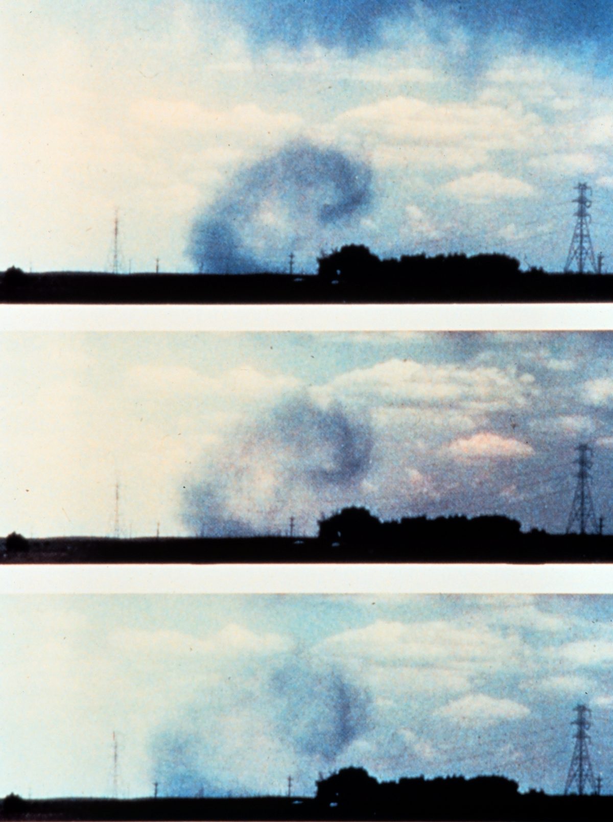
A downburst is a strong downdraught that bursts out across the ground as damaging wind. The meteorologist Ted Fujita identified it while analysing the 1975 Eastern Air Lines accident at New York, and the NIMROD and JAWS field projects of 1978 and 1982 confirmed it. Fujita classified downbursts by size. A microburst has an outflow no more than 4 km (2.5 miles) across, with peak winds lasting only two to five minutes. A macroburst is larger, and its damaging winds last 5 to 30 minutes.
Falling precipitation drags air down, and evaporation, melting and sublimation chill it until it is denser than its surroundings, so the column accelerates towards the ground. On reaching the surface it turns and spreads out radially as the microburst outflow, whose leading edge often curls upward.
The FAA AIM gives these typical values:
| Characteristic | Typical value |
|---|---|
| Downdraught diameter | Less than 1 mile, from cloud base to about 1,000 to 3,000 ft above the ground |
| Outflow diameter | Up to about 2.5 miles |
| Downdraught speed | Up to 6,000 ft/min |
| Horizontal wind | Up to 45 kt each side, so up to 90 kt of shear across the burst |
| Life | Intensifies for about 5 minutes after touching down; strongest winds last 2 to 4 minutes; seldom over 15 minutes in total |
Microbursts can line up and keep a line active for up to an hour, and once one has occurred, others nearby should be expected.
An aeroplane crossing a microburst meets a fixed sequence: an increasing headwind that raises the airspeed, then the downdraught, then an increasing tailwind that takes the airspeed away while the aeroplane is already sinking. On take-off the order is the same, with less height and speed to spare.

Exam tip: Remember "headwind, downdraught, tailwind" and the round figures of 6,000 ft/min down and 90 kt of total shear. ATPL questions may quote slightly different round values for the outflow and lifetime; the downdraught figure is the one that is always the same.
Wet and dry microbursts
A wet microburst comes with heavy precipitation at the surface and usually gives a strong echo on weather radar. A dry microburst brings little or no precipitation to the ground. It falls from a high-based convective cloud through a deep, dry layer, where the evaporating rain cools the air and drives the downdraught. It is common in the US High Plains and intermountain west, where the Denver JAWS project studied it.
The FAA AIM warns that microbursts can occur wherever there is convection, hidden in heavy thunderstorm rain or beneath harmless-looking virga. EASA exam material links them with summer air-mass storms over dry ground. Visual clues are virga beneath a high cloud base, a ring of blowing dust on the ground, strong rain or hail shafts, and trees or crops blown in different directions.

Warning: A dry microburst returns little radar energy, so a quiet weather radar or a clear predictive windshear display does not prove the air is safe.
Detection: LLWAS, TDWR and warnings
The Low-Level Windshear Alert System (LLWAS) is a network of anemometers on poles around the airport and along the approach and departure paths, built in response to the Eastern 66 accident. It compares their winds to detect divergence and gust fronts. The basic system gives windshear alerts but not microburst alerts. The expanded versions (LLWAS-NE and LLWAS-RS) can also give microburst alerts and are integrated with Doppler radar.
The Terminal Doppler Weather Radar (TDWR) is a dedicated Doppler radar near a major airport. It measures the speed of precipitation towards or away from the antenna, revealing divergent outflows and gust fronts before they reach the runway. The FAA installed 45 TDWRs and added a Weather Systems Processor to the ASR-9 surveillance radar at 34 airports with a history of windshear.
ATC passes runway-specific alerts, for example "runway 17 arrival, microburst alert, 40 knot loss, 3 mile final". A microburst alert means an expected airspeed loss of 30 kt or more; smaller losses or gains are reported as windshear alerts. Many operators treat a microburst alert as a bar to take-off or approach until it is cancelled.
Under ICAO Annex 3, the aerodrome meteorological office issues a windshear warning for observed or expected shear between runway level and 500 m (1,600 ft) that could affect aeroplanes on approach, take-off or circling, or on the runway. Shear may also appear in a METAR as WS followed by the runway, for example WS R27 (see METAR and SPECI).
Airborne systems come in two kinds (see GPWS and TAWS):
- Reactive systems, such as GPWS mode 7 or the Airbus flight computers, calculate the shear from air data and inertial data and warn once the aeroplane is already in it: a red WINDSHEAR indication and "WINDSHEAR, WINDSHEAR, WINDSHEAR". On the A320 the reactive system works on take-off and below 1,300 ft radio altitude with flaps extended.
- Predictive systems use the Doppler function of the weather radar to find a divergent outflow ahead. The Airbus system scans 5 NM ahead below 2,300 ft, giving an amber W/S AHEAD caution and then a red warning with "WINDSHEAR AHEAD" on take-off or "GO AROUND, WINDSHEAR AHEAD" on approach.
Windshear warnings rank below stall warning but above GPWS and TCAS alerts.
The rules differ. Under 14 CFR 121.358, turbine aeroplanes flown by US airlines and manufactured after 2 January 1991 must carry an approved airborne windshear warning and flight guidance system, a detection and avoidance system, or a combination of the two. ICAO Annex 6 only recommends a forward-looking system for turbojet aeroplanes over 5,700 kg or authorised to carry more than nine passengers. EASA's air operations rules contain no equivalent carriage requirement; European operators rely on the systems the manufacturer fits and on training.
Recognition and recovery
Avoidance comes first: delay the take-off or approach while convective activity is at or near the airport. Use full rated take-off thrust rather than a reduced setting when shear is possible, and report any encounter to ATC with the airspeed loss or gain and the height at which it occurred.
When no system alerts, the Windshear Training Aid calls for the escape manoeuvre on any uncontrolled deviation below 1,000 ft above ground beyond these limits:
- 15 kt indicated airspeed
- 500 ft/min vertical speed
- 5° pitch attitude
- one dot of glideslope displacement
- an unusual thrust lever position held for a significant time
The escape manoeuvre is flown on attitude and thrust, not speed:
- Thrust: maximum available, normally TOGA, set without delay.
- Pitch: roll wings level and pitch up. Boeing specifies an initial 15°, the same figure found in EASA-based training texts, then flight director guidance. Airbus crews set TOGA and follow the SRS pitch bar, or use up to 17.5° without a flight director, with full back stick if necessary.
- Stall margin: the stick shaker, or angle-of-attack protection on a fly-by-wire Airbus, is the upper pitch limit; intermittent shaker is acceptable. Do not lower the nose to chase airspeed.
- Configuration: retract the speedbrakes, but leave flaps and landing gear alone until clear of the shear.
Warning: A windshear escape is not a normal go-around. Retracting flaps or gear inside the shear costs lift and attention at the worst moment. Hold the manoeuvre until clearly climbing away, then tell ATC.
For recovery from any resulting loss of control, see upset prevention and recovery.
Accidents that shaped the defences
- Eastern Air Lines 66, 24 June 1975: a Boeing 727 approaching runway 22L at New York JFK flew into the approach lights about 2,400 ft short of the threshold, killing 113 of the 124 on board. Fujita's analysis produced the downburst concept, and LLWAS followed.
- Pan Am 759, 9 July 1982: a Boeing 727 taking off from New Orleans was forced down by microburst-induced shear shortly after lift-off and crashed into a Kenner neighbourhood, killing all 145 on board and 8 on the ground.
- Delta Air Lines 191, 2 August 1985: an L-1011 approaching Dallas/Fort Worth through a thunderstorm met a microburst and struck the ground more than a mile short of the runway; 137 people died, one of them on the ground. It prompted the Weather Systems Processor and added urgency to the US requirement for airborne windshear equipment.
Frequently asked questions
What is the difference between a microburst and a macroburst?
Both are downbursts, strong downdraughts that spread out violently on reaching the ground. The distinction, introduced by Ted Fujita, is size and duration. A microburst has an outflow no more than about 4 km (2.5 miles) across, with peak winds lasting only a few minutes. A macroburst covers a larger area and its damaging winds can last 5 to 30 minutes.
Why is a sudden airspeed increase on final approach a windshear warning?
An aeroplane flying into a microburst first meets the outflow as an increasing headwind, so the airspeed rises and it balloons above the glide path. Moments later come the downdraught and then an increasing tailwind that take the speed away again. A pilot who has just reduced thrust to correct the gain is left short of energy near the ground, so an unexplained gain in convective weather should prompt a go-around.
How strong can a microburst be?
The FAA AIM gives downdraughts as strong as 6,000 ft/min and horizontal winds near the surface of up to 45 kt, which means a change of up to 90 kt from headwind to tailwind for an aeroplane crossing it. The burst keeps strengthening for about five minutes after it reaches the ground, its strongest winds last about two to four minutes, and it seldom lasts longer than 15 minutes in total.
What is the difference between reactive and predictive windshear systems?
A reactive system, such as GPWS mode 7, calculates the shear from air data and inertial data and warns once the aeroplane is already in it, typically with a triple WINDSHEAR aural alert. A predictive system uses the Doppler function of the weather radar to detect a divergent outflow a few miles ahead and gives a WINDSHEAR AHEAD alert before the encounter. Predictive systems need some precipitation to see.
What is the windshear escape manoeuvre?
The crew applies maximum thrust, rolls the wings level and pitches up, typically towards 15 degrees on Boeing types or following the SRS pitch bar on Airbus types, using the stick shaker or angle-of-attack protection as the upper limit. Speedbrakes are retracted, but flaps and landing gear are left where they are until clear of the shear. The encounter is then reported to ATC.
Test yourself on Windshear and Microbursts
The v1prep banks cover this topic in Meteorology (050), with a worked explanation for every answer. EASA ATPL, PPL, IR and CPL, the FAA written tests and A320/B737 type ratings.
Start practising →Sources and further reading
- FAA Aeronautical Information Manual, Chapter 7, Section 1 (Microbursts, Pilot Reports of Wind Shear)
- FAA Advisory Circular AC 00-54, Pilot Windshear Guide (cancelled, content now in FAA-H-8083-28)
- ICAO Doc 9817, Manual on Low-level Wind Shear (SKYbrary bookshelf)
- FAA, Wind Shear Detection Services (LLWAS, TDWR, WSP)
- Flight Safety Foundation ALAR Briefing Note 5.4, Wind Shear
- Airbus Flight Operations Briefing Note, Adverse Weather Operations, Windshear Awareness (SKYbrary bookshelf)
- EASA NPA 2016-18, Prediction of wind shear for aeroplanes performing commercial air transport operations
- Bulletin of the American Meteorological Society (2022), Addressing the Microburst Threat to Aviation
Library articles are written for study and exam preparation. They do not replace your aircraft's approved documentation, your operator's procedures or the regulations themselves.