Airborne Weather Radar
Airborne weather radar is a forward-looking primary radar, working in the X band, that detects precipitation by the energy it reflects and displays its intensity, so that the crew can locate and avoid thunderstorms and the hail, turbulence and windshear that accompany them.
Weather radar, in full airborne weather radar (AWR, or WXR on flight deck panels), is a forward-looking primary radar that transmits pulses of microwave energy from an antenna in the nose and displays the echoes returned by precipitation. It sees water, not cloud. Large raindrops and wet hail return strong echoes; cloud droplets, dry snow and ice crystals return little; clear air turbulence, volcanic ash and a dry microburst return almost nothing. Everything a crew infers about hail, turbulence and windshear in a thunderstorm rests on that one measurement, so tilt, gain and interpretation matter.
EASA's CAT.IDE.A.160 requires airborne weather detecting equipment on pressurised aeroplanes, and on unpressurised ones above 5,700 kg MCTOM or with more than nine passenger seats, when they fly at night or in IMC where thunderstorms or other detectable hazardous weather may be expected; the AMC calls for a radar except on small pressurised propeller aeroplanes. In the United States, 14 CFR 121.357 requires approved weather radar on transport category airliners and forbids dispatch under IFR or night VFR, with thunderstorms or other radar-detectable hazards expected along the route, unless it works.
- Weather radar principle
- Pencil and fan beams
- Antenna tilt and autotilt
- Gain and colour coding
- Ground mapping and ground clutter
- Attenuation and radar shadow
- Turbulence and predictive windshear modes
- Other radar functions
- Lightning detection systems
- Avoiding storms with the radar
- Safety on the ground
- Frequently asked questions
Weather radar principle
The radar is a pulse radar working in the X band, around 9.3 GHz, with a wavelength of about 3.2 cm. The wavelength is short enough for a nose-sized antenna to form a narrow beam and get strong echoes from raindrops, yet long enough not to be stopped by the first shower. Range comes from timing, each nautical mile of range adding about 12.36 µs to the round trip.
The strength of an echo depends on the size and number of the targets and on whether they are liquid. Reflectivity rises with about the sixth power of drop diameter, so a few large drops outweigh many small ones, and an ice particle returns only about a fifth of the echo of a water drop of the same size. Wet hail and heavy rain therefore paint strongest, wet snow moderately, and dry hail, dry snow and ice crystals weakly.
Modern radars also use the Doppler principle: they measure the frequency shift caused by precipitation moving towards or away from the antenna, the basis of turbulence and windshear detection. The antenna, normally a flat-plate array in the nose radome, sweeps from side to side, through a 180° arc on the Boeing 737, and is stabilised in pitch and roll so that the picture stays level in turns. A wet, iced or damaged radome absorbs energy and weakens the whole picture.
Pencil and fan beams
A pencil beam is a narrow cone used for weather detection and long-range mapping. Its width depends on the size of the antenna relative to the wavelength: roughly 3° for a 30-inch (76 cm) airliner antenna, and 7° or more for the 12-inch (30 cm) antennas of light aircraft. A cosecant-squared (fan) beam spreads the energy downwards in a vertical fan, giving fairly even ground returns over a band of distances; some radars use it for short-range ground mapping.
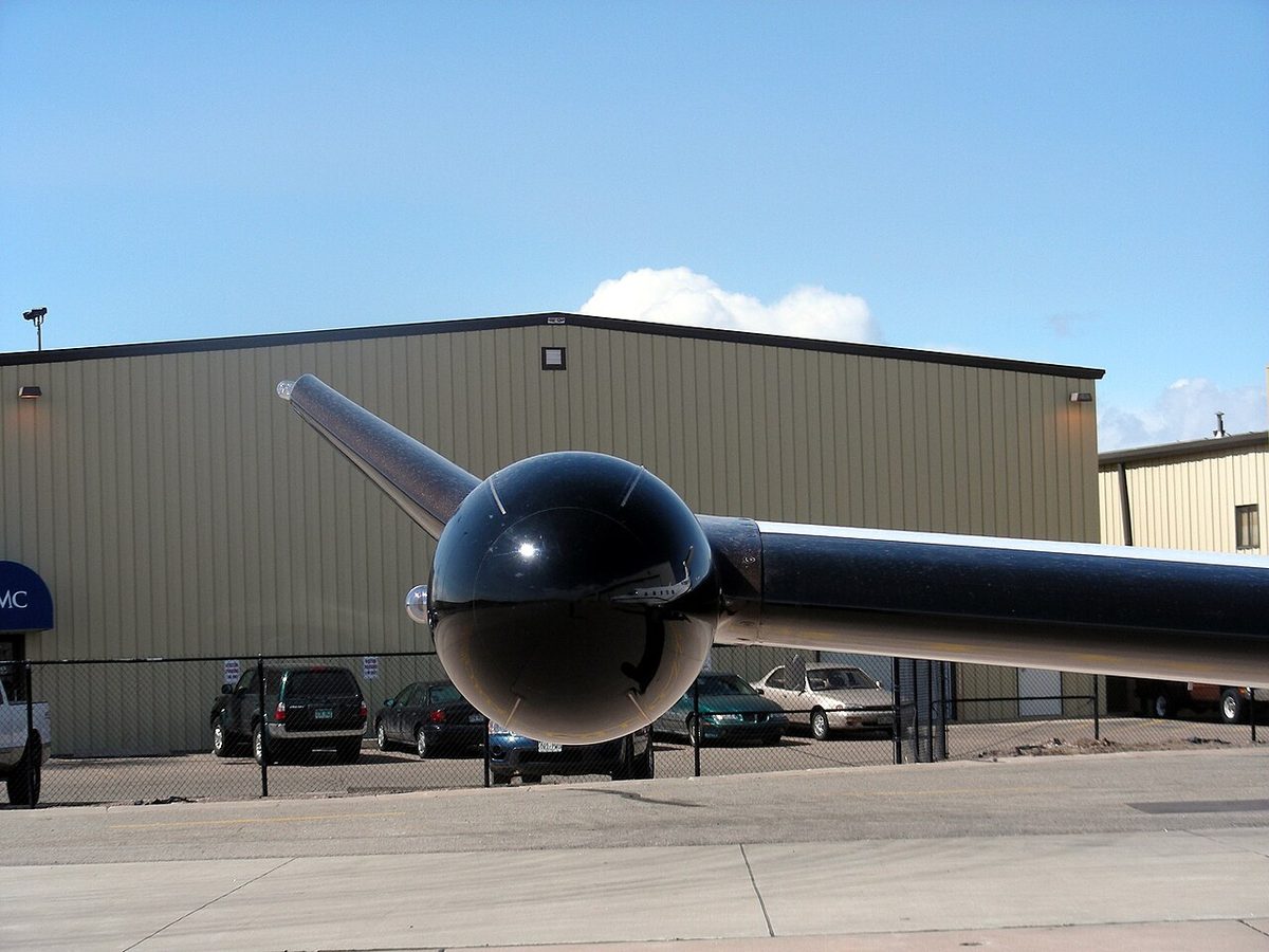
The beam grows with range. One degree subtends about 100 ft for each nautical mile, so at 100 NM a 3° beam is some 32,000 ft deep. A distant storm may only partly fill the beam and look weaker than it is, and two cells a few miles apart may merge into one return.
Antenna tilt and autotilt
Antenna tilt, also called weather radar tilt or radar antenna tilt, is the angle of the beam centre above or below the horizon. Because the antenna is stabilised, tilt is measured from the horizon, not from the fuselage. One degree of tilt moves the beam centre about 4,200 ft at 40 NM and about 10,600 ft at 100 NM.
Manual technique follows a common pattern:
- Cruise: tilt down until ground returns appear at the top of the display, then raise the tilt slightly. Weather painted closer than the ground returns is then within the beam.
- Scan the cell: the most reflective part of a storm lies below the freezing level, where the precipitation is liquid. At high cruise levels a beam aimed level looks at the icy upper part, which paints weakly, so a severe cell can look harmless. Tilting down into the wet core gives the true picture.
- Take-off and approach: tilt up, Airbus suggests about 4°, to keep ground returns out and look along the flight path.
- Cell tops: raise the tilt until the return just disappears; the reflective top lies roughly tilt × range × 100 ft above the aircraft, and the cloud extends higher.
Autotilt sets the tilt automatically. The A320 version uses the EGPWS terrain database with aircraft position and altitude and the selected ND range: above 2,300 ft AGL it optimises for long range on the 160 and 320 NM ranges and for short range on 10 to 80 NM, and on the ground it aims at weather 10,000 ft above ground level. Collins' Multiscan radar scans at more than one tilt angle, merges the results and suppresses ground returns; Airbus recommends its automatic mode as the normal setting, and its overflight protection guards against weakly reflective storm tops. Manual tilt remains the tool for analysing a particular cell.
Gain and colour coding
Weather radar gain sets receiver sensitivity. In the calibrated position (CAL or AUTO) the display colours correspond to defined reflectivity levels; in manual gain they do not. Reducing gain finds the strongest cores, because a cell that stays red at reduced gain is a strong one. Increasing it reveals weak returns at long range; afterwards the gain goes back to calibrated.
Weather radar colour coding follows a common scheme on a black background, although thresholds vary between manufacturers:
| Colour | Approximate reflectivity | Approximate rainfall rate | FAA intensity term |
|---|---|---|---|
| Black | below about 20 dBZ | very light or none | – |
| Green | 20 to 30 dBZ | 1 to 4 mm/h | Light (below 30 dBZ) |
| Yellow or amber | 30 to 40 dBZ | 4 to 12 mm/h | Moderate |
| Red | 40 to 50 dBZ | 12 to 50 mm/h | Heavy |
| Magenta | above 50 dBZ | above 50 mm/h | Extreme |
On radars without a fourth precipitation level, red covers everything above about 40 dBZ and magenta is reserved for turbulence. The FAA intensity terms are those air traffic controllers use when describing echoes.
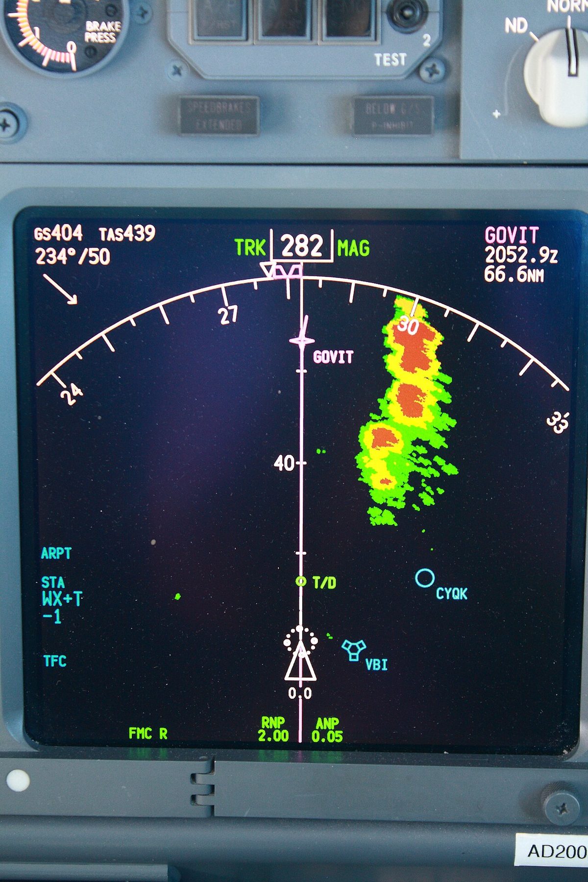
Hail and turbulence show in shape and gradient more than in colour. Steep gradients, where green, amber and red are packed closely together, and fingers, hooks, U-shapes and scalloped edges point to hail and strong updraughts.

Ground mapping and ground clutter
Weather radar ground mapping mode (MAP) tilts the beam down to paint the ground. Cities and mountains reflect strongly and coastlines stand out, because smooth water reflects the energy away and appears black. The 737 map shows surfaces in red, amber and green from most to least reflective. The A320 documentation describes water as black, land as green and cities and mountains as amber. Mapping can confirm position where navigation aids are sparse, but the 737 manual states that the radar is not to be relied on for proximity warning or anti-collision protection (see GPWS and TAWS).
Ground clutter is ground return appearing unwanted in weather mode, typically at low altitude or with too much down-tilt. Ground returns change shape and intensity markedly with small tilt changes, whereas weather changes more gradually, and many radars apply clutter suppression. Terrain and weather cannot share a 737 display: if one pilot selects terrain and the other weather, each display updates on alternate sweeps.
Attenuation and radar shadow
Radar attenuation is the loss of energy as the beam passes through precipitation. Each band of heavy rain absorbs and scatters part of the pulse, so anything beyond it paints weaker than it is, and a weak return behind a strong one may be the more severe storm. Once the beam is absorbed completely, nothing beyond can be displayed.
A radar shadow is that extreme case: a black area extending away from a strong cell, from which no echo returns. With the tilt down, the sign is a wedge of missing ground returns behind the cell. Airbus advises treating a black hole behind a red area as potentially very active. A shadow also forms behind high ground in mapping mode. A deviation should never be planned into a shadow.
Turbulence and predictive windshear modes
Weather radar turbulence mode (WX/TURB) uses the Doppler measurement to find precipitation whose velocity varies sharply, the signature of turbulence. On the 737, when the radar detects precipitation moving horizontally at 5 m/s or more towards or away from the antenna, that area is painted magenta and associated with heavy turbulence. Detection is limited to 40 NM whatever range is selected, and it needs precipitation, so clear air turbulence never appears. Other radars, Collins' MultiScan among them, also limit turbulence detection to about 40 NM.
The predictive windshear system (PWS) uses the same Doppler function to detect the divergent outflow of a microburst ahead, headwind on one side and tailwind on the other, before the aircraft enters it (see windshear and microbursts):
- Boeing 737: scanning starts automatically when the thrust levers are set for take-off, or in flight below 2,300 ft RA, and the sweep narrows to 120°. Alerts are issued below 1,200 ft RA: "WINDSHEAR AHEAD" on take-off, "GO AROUND, WINDSHEAR AHEAD" on approach for windshear within 1.5 NM, and the caution "MONITOR RADAR DISPLAY" within 3 NM. New cautions are inhibited between 80 kt and 400 ft RA, new warnings between 100 kt and 50 ft RA.
- Airbus A320: the PWS works below 2,300 ft AGL with its switch at AUTO, even with the radar display off, provided the transponder is on and an engine is running. It scans 5 NM ahead and gives the same aural messages with W/S AHEAD on the PFD. Alerts are inhibited on take-off from 100 kt to 50 ft and on landing below 50 ft.
A dry microburst may return too little energy to be detected, so a clear PWS display is no guarantee.
Other radar functions
The weather radar HOLD function freezes the displayed picture. Comparing it with the live image a little later shows how cells are moving relative to the aircraft.
Target alert (TGT ALERT) warns of strong returns ahead that lie beyond the displayed range. On Honeywell Primus radars it monitors beyond the selected range within 7.5° either side of the heading and changes the TGT legend to a yellow warning when it finds a red-level target. Coverage differs between radars. On the 737, returns are displayed no farther than 320 NM even on the 640 NM range.
Lightning detection systems
A lightning detector is a passive receiver that listens for the radio pulses emitted by electrical discharges. The best-known type, the Stormscope, finds the bearing of each discharge with a crossed-loop antenna and estimates its range from signal strength, assuming all discharges are equally powerful. Strong discharges therefore appear too close, and a distant cell smears towards the aircraft symbol, an effect called radial spread. It marks active convection but neither measures rainfall nor gives accurate range, so it complements radar. EASA's AMC accepts such equipment instead of radar only on small pressurised propeller aeroplanes; FAA Part 135 accepts approved thunderstorm detection equipment in some cases.
Avoiding storms with the radar
The FAA AIM advises avoiding by at least 20 NM any thunderstorm identified as severe or giving an intense radar echo. Airbus gives the same 20 NM laterally, preferably upwind, where hail and turbulence are less likely, and at least 5,000 ft vertically. EASA sets no single figure; operators publish minima in the operations manual. Deviations should be decided early, planned on a long range and flown on a short one, and never taken into a shadow or an area the beam has not scanned. Weak returns at cruise level above strong returns lower down can mean high concentrations of ice crystals, which threaten engines and air data probes (see airframe icing).
Safety on the ground
Weather radar radiates enough microwave energy to harm people close in front of the antenna and to ignite fuel vapour. FAA AC 20-68B recommends establishing minimum safe distances for personnel and not operating the radar while the aircraft is being refuelled or defuelled. Boeing's 737 limitations add that the radar should not be operated in a hangar, where reflections concentrate the energy, or when personnel are within the area normally enclosed by the nose radome. Airbus procedures switch the radar and the PWS off after landing so as not to irradiate people at the gate, and the windshear function transmits automatically for take-off even with the weather display off. EASA has no equivalent AC; manufacturer and operator procedures apply.
Exam tip: the radar sees water, not cloud or turbulence. Expect wet hail as the strongest return, X band at about 3 cm, stabilised tilt, calibrated gain, attenuation behind heavy rain, turbulence only in precipitation and 20 NM avoidance.
Frequently asked questions
What do the colours on a weather radar display mean?
With the gain calibrated, black means no significant return, green light precipitation, yellow or amber moderate, red heavy and, on radars with a fourth level, magenta extreme. In turbulence mode magenta instead marks precipitation moving turbulently. The colours measure rainfall intensity, not turbulence or cloud, so steep colour gradients and shapes such as hooks and fingers matter as much as the colour itself. In manual gain the colours lose their calibrated meaning.
How far should aircraft stay away from thunderstorms seen on weather radar?
The FAA AIM advises avoiding any storm identified as severe, or giving an intense radar echo, by at least 20 NM. Airbus gives the same lateral figure, preferably on the upwind side, and at least 5,000 ft vertically. Two such cells less than 40 NM apart leave no safe gap. EASA sets no single distance; operators publish minima in their operations manuals, normally based on manufacturer guidance.
Can weather radar detect turbulence?
Only where there is precipitation to reflect the beam. Doppler turbulence modes measure how sharply the speed of the precipitation varies and paint turbulent areas magenta, typically out to 40 NM. Clear air turbulence, turbulence above the reflective part of a storm and the outflow of a dry microburst return too little energy to be seen, so a quiet display does not prove smooth air.
What is radar attenuation and radar shadow?
Attenuation is the weakening of the beam as heavy precipitation absorbs and scatters it, so cells beyond a strong one paint weaker than they really are. When the beam is absorbed completely, the area behind the cell appears black, which is a radar shadow. With the tilt down, the missing ground returns behind the cell betray it. A black area behind a red cell must be treated as potentially very active.
Is it safe to use weather radar on the ground?
Only with precautions. The transmitter radiates enough microwave energy to harm people close in front of the antenna and to ignite fuel vapour. FAA guidance calls for safe distances and no transmission during refuelling or defuelling. Boeing's limitations add no operation in a hangar or with people inside the area enclosed by the nose radome, and Airbus crews switch the radar and predictive windshear off after landing to protect people at the gate.
How should weather radar tilt be set?
In cruise, tilt the beam down until ground returns just appear at the top of the display, then raise it slightly, and scan up and down regularly to find the wet, reflective part of each cell below the freezing level. For take-off and approach, tilt up a few degrees to keep the ground out of the picture. One degree of tilt moves the beam centre about 100 ft for every nautical mile of range.
Test yourself on Airborne Weather Radar
The v1prep banks cover this topic in Instrumentation (022), with a worked explanation for every answer. EASA ATPL, PPL, IR and CPL, the FAA written tests and A320/B737 type ratings.
Start practising →Sources and further reading
- Airbus Flight Operations Briefing Note, Adverse Weather Operations, Optimum Use of the Weather Radar
- Airbus Safety First, Optimum Use of the Weather Radar
- FAA Aeronautical Information Manual, Chapter 7, Safety of Flight
- FAA InFO 07008, Weather radar echo intensity terminology
- FAA AC 20-68B, Recommended Radiation Safety Precautions for Ground Operation of Airborne Weather Radar
- 14 CFR 121.357, Airborne weather radar equipment requirements
- Regulation (EU) 965/2012, CAT.IDE.A.160 Airborne weather detecting equipment (UK CAA regulatory library)
- Collins Aerospace, WXR-2100 MultiScan ThreatTrack weather radar
Library articles are written for study and exam preparation. They do not replace your aircraft's approved documentation, your operator's procedures or the regulations themselves.