Cloud Cover and Ceiling
Cloud cover is the fraction of the sky hidden by cloud, measured in eighths called oktas and reported as FEW, SCT, BKN or OVC. The ceiling is the height of the base of the lowest cloud layer covering more than half the sky; in the United States a vertical visibility into an obscured sky also counts.
Cloud cover is how much of the sky is hidden by cloud, and the ceiling is the height of the lowest layer that covers more than half of it. With visibility, they are the numbers that decide whether a VFR flight can go, whether an instrument approach is likely to end in a landing and whether an alternate is needed. They appear in every METAR, TAF and ATIS broadcast.
The reporting rules come from ICAO Annex 3 and the WMO codes, applied in the EU through Part-MET. The United States reports the same cloud amounts but uses some different terms and definitions, and those differences are noted throughout. For the rest of the report, see METAR and SPECI and TAF and trend forecasts.
Measuring cloud amount in oktas
Cloud amount is measured in oktas, eighths of the sky. An observer estimates the fraction of the whole sky covered by each layer of cloud, from 0 for none to 8 for a sky completely covered. US reports use the same eighths.
An automatic station cannot see the whole sky. Its ceilometer looks straight up and sees only the cloud that drifts over it, so the amount it reports is built up from what passes overhead over a period of time. A layer that stays to one side of the aerodrome can be missed, and the station can name cumulonimbus or towering cumulus only if it has a separate means of detecting convective cloud.
Reporting codes: FEW, SCT, BKN, OVC
| Code | Name | Amount |
|---|---|---|
| FEW | Few | 1 to 2 oktas |
| SCT | Scattered | 3 to 4 oktas |
| BKN | Broken | 5 to 7 oktas: more than half the sky, not all of it |
| OVC | Overcast | 8 oktas: the whole sky |
Each cloud group gives the amount followed by the base in hundreds of feet. Under ICAO rules the base is a height above the aerodrome elevation; in US reports it is above ground level, which at an airport comes to the same thing. BKN019 is 5 to 7 oktas based at 1,900 ft. Layers are listed from the lowest upwards, as in FEW008 SCT015 BKN030 OVC050.
Cumulonimbus and towering cumulus are the only cloud types ever named, by adding CB or TCU to the group, as in SCT030CB or BKN025TCU. An automatic station that cannot identify the type adds three slashes instead, as in FEW110///.
ICAO reports concentrate on cloud of operational significance: cloud below 5,000 ft or the highest minimum sector altitude, whichever is greater, and CB or TCU at any height. France, for one, notifies in AIP France GEN 1.7 that it also reports significant layers above that level. US automated stations report cloud only up to 12,000 ft. TAFs use the same codes as METARs.
Cloud base and ceiling definitions
The cloud base is the lowest zone in which the obscuration changes perceptibly from clear air or haze to water droplets or ice crystals. It is reported as a height above the aerodrome, not an altitude: a broken layer at 1,500 ft over an airport at 5,431 ft elevation lies at about 6,931 ft above mean sea level, which is what matters for terrain clearance and for the level at which to expect icing.
The ceiling, or cloud ceiling, is defined in EASA training texts as the height above the aerodrome of the base of the lowest cloud layer covering more than half the sky, in other words more than 4 oktas, reported as BKN or OVC. Some texts also call it the main cloud base.
The FAA definition in 14 CFR 1.1 is wider: the ceiling is the lowest layer reported as broken or overcast, or the vertical visibility into an obscuration that hides the whole sky. In both systems few and scattered layers never form a ceiling. For FEW008 SCT015 BKN030 OVC050 the ceiling is 3,000 ft, however low the scattered cloud beneath it.
Exam tip: Look for the first BKN, OVC or VV group; everything below it is not the ceiling. A scattered layer below the ceiling can still hide the approach lights at the wrong moment, so plan for it.
Why the ceiling matters
- ICAO and EASA VFR. Under the rules of the air of ICAO Annex 2 and the EU's SERA, unless ATC authorises it, a VFR flight may not take off or land at an aerodrome within a control zone, or enter its aerodrome traffic zone or traffic circuit, when the ceiling is below 1,500 ft (450 m) or the ground visibility below 5 km (see VFR, IFR and meteorological conditions).
- FAA VFR. 14 CFR 91.155 prohibits VFR flight beneath the ceiling within the lateral limits of controlled airspace designated to the surface for an airport when the ceiling is below 1,000 ft, unless the flight is under special VFR.
- FAA alternates. Under 14 CFR 91.169 an aeroplane on an IFR flight to an airport with a published instrument approach needs no alternate if, from 1 hour before to 1 hour after the estimated arrival, the forecast ceiling is at least 2,000 ft above the airport and the visibility at least 3 SM. An alternate's standard minima, where the chart gives none, are a ceiling of 600 ft and 2 SM for a precision approach and 800 ft and 2 SM for a non-precision approach. EASA operators apply their own planning minima (see aerodrome operating minima).
- Special reports. Under ICAO rules a SPECI is issued when the base of the lowest BKN or OVC layer passes 100, 200, 500 or 1,000 ft, and 1,500 ft for VFR operations. US stations issue one when the ceiling passes 3,000, 1,500, 1,000 or 500 ft, or the lowest approach minimum.
US weather displays also colour airports by flight category, which uses the ceiling and the visibility together, the worse of the two setting the category:
| FAA category | Ceiling | Visibility |
|---|---|---|
| LIFR | Below 500 ft | Below 1 SM |
| IFR | 500 to below 1,000 ft | 1 to below 3 SM |
| MVFR | 1,000 to 3,000 ft | 3 to 5 SM |
| VFR | Above 3,000 ft | Above 5 SM |
These categories are planning aids, not legal minima.
NSC, NCD, SKC and CLR
When no cloud group can be given, one of four codes appears:
| Code | Meaning | Used in |
|---|---|---|
| NSC | No significant cloud: none below 5,000 ft or the highest minimum sector altitude, whichever is greater, and no CB or TCU, while CAVOK does not apply | ICAO METAR and TAF |
| NCD | No cloud detected by an automatic system | ICAO automated METAR |
| SKC | Sky clear: no cloud at all | US reports by human observers, and US TAFs |
| CLR | No cloud detected below 12,000 ft by an automated station | US automated METAR |
NSC does not mean a clear sky: there may be cloud above 5,000 ft or the sector altitude. It is used when the cloud conditions for CAVOK are met but the visibility or the weather rules CAVOK out, as in 3000 BR NSC. NCD is a statement about the sensor, not the sky. France applies a variation when a fully automatic system detects no cloud: it reports NSC if the system can detect convective cloud and has found none, and NCD if it has no means of detecting convective cloud (AIP France GEN 1.7). The two US codes differ in the same way: SKC is an observer's judgement of the whole sky, while CLR only says that the ceilometer found nothing below 12,000 ft.
CAVOK criteria
CAVOK, spoken "cav-oh-kay" and short for ceiling and visibility OK, replaces the visibility, RVR, present weather and cloud groups when all four of these conditions hold at the same time:
- visibility 10 km or more;
- no cloud below 5,000 ft or the highest minimum sector altitude, whichever is greater;
- no cumulonimbus or towering cumulus at any height;
- no significant weather.
The cloud condition is tied to the highest minimum sector altitude so that CAVOK tells a pilot that visual manoeuvring above the terrain around the aerodrome is possible, not just that the sky looks pleasant. The CB and TCU condition is absolute: a single towering cumulus at 20,000 ft prevents CAVOK. CAVOK says nothing about the wind and does not promise a clear sky. It is used in METARs, TAFs and trend forecasts, but not in US reports or forecasts.
Exam tip: CAVOK needs all four conditions at once. A single towering cumulus at any height rules it out, and so does a cloud layer above 5,000 ft if it lies below the highest minimum sector altitude.
Vertical visibility in an obscured sky
When fog, heavy snow or another obscuration hides the sky so completely that no cloud amount or base can be observed, the cloud group is replaced by vertical visibility (VV) followed by a height in hundreds of feet. VV002 means that the observer or ceilometer can see 200 ft up into the obscuration. When even that cannot be assessed, the group reads VV///. In France, automated METARs give VV/// in place of a vertical visibility value whenever the sky is obscured (AIP France GEN 1.7).
A typical report is 0400 FZFG VV002 M03/M03: visibility 400 m in freezing fog, vertical visibility 200 ft, temperature and dew point both −3 °C.

Vertical visibility is not a cloud base. Operationally it stands in for the ceiling: the FAA treats it as an indefinite ceiling for VFR minima, for the alternate rules of 14 CFR 91.169 and for approach planning. It measures how far one can see straight up, however, and a pilot looking forward and down through the fog at decision height sees much less. Even with a vertical visibility above the decision height, the runway environment may not be in sight, and a missed approach should be expected (see fog).
Measuring cloud base: ceilometers
A ceilometer measures the height of the cloud base. The laser ceilometer, now the main type in use, consists of a vertically pointing laser and a receiver. It measures the time a pulse of light takes to be scattered back from the cloud base, and so the height. It is more accurate and reliable than older ceilometer types, and it has replaced the traditional methods: by day, releasing a balloon with a known rate of climb and timing it until it disappeared into cloud; by night, shining a searchlight vertically on to the cloud base and measuring the angle to the spot of light with an alidade.
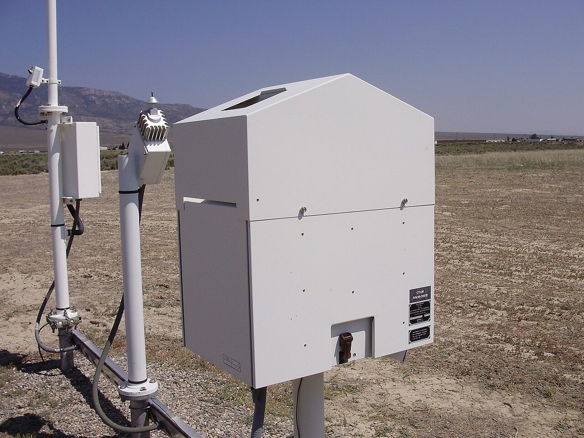
A ceilometer measures only the cloud directly above it. The cloud base over the approach may differ from the value in the report, and pilot reports of bases and tops remain valuable. In the United States, the 12,000 ft reporting limit of automated stations is the reason for the CLR code.
Cloud also shapes the ATIS. Under ICAO practice the broadcast gives the significant cloud among its routine items. The FAA allows the ceiling, visibility and obstructions to vision to be omitted when the ceiling is above 5,000 ft and the visibility more than 5 miles, the familiar "better than 5000 and 5".
Frequently asked questions
What is a ceiling in aviation?
The ceiling is the height of the base of the lowest cloud layer that covers more than half the sky, that is a layer reported as broken (BKN, 5 to 7 oktas) or overcast (OVC, 8 oktas). Few and scattered layers never form a ceiling. Under the FAA definition in 14 CFR 1.1, a vertical visibility into an obscured sky, such as VV003, also counts as a ceiling. Heights are above the aerodrome, not above sea level.
How many oktas are FEW, SCT, BKN and OVC?
An okta is one eighth of the sky. FEW means 1 to 2 oktas, SCT (scattered) 3 to 4 oktas, BKN (broken) 5 to 7 oktas and OVC (overcast) 8 oktas, a completely covered sky. In a METAR or TAF each amount is followed by the base in hundreds of feet above the aerodrome, so BKN012 is 5 to 7 oktas based at 1,200 ft.
What is the difference between NSC and NCD?
NSC, no significant cloud, means there is no cloud below 5,000 ft or the highest minimum sector altitude, whichever is greater, and no cumulonimbus or towering cumulus at any height, while CAVOK cannot be used because of the visibility or weather. Cloud may still exist higher up. NCD, no cloud detected, is used only by automatic stations whose sensors have detected no cloud at all.
What is the difference between SKC and CLR?
Both appear in US weather reports. SKC, sky clear, is used by a human observer when there is no cloud at all, and in US TAFs for a forecast clear sky. CLR is used by automated stations and means only that no cloud was detected below 12,000 ft, because the ceilometer cannot report higher. ICAO reports use CAVOK, NSC or NCD instead.
What does VV mean in a METAR?
VV is vertical visibility. It replaces the cloud group when fog, snow or another obscuration hides the sky so that no cloud amount or base can be observed. It is followed by the height in hundreds of feet, so VV002 means the observer or sensor can see 200 ft upwards. It is treated as the ceiling, although a pilot looking ahead through the obscuration on an approach will see much less.
Test yourself on Cloud Cover and Ceiling
The v1prep banks cover this topic in Meteorology (050), with a worked explanation for every answer. EASA ATPL, PPL, IR and CPL, the FAA written tests and A320/B737 type ratings.
Start practising →Sources and further reading
- WMO-No. 782, Aerodrome Reports and Forecasts, A Users' Handbook to the Codes
- Federal Meteorological Handbook No. 1 (FMH-1), Surface Weather Observations and Reports (2019)
- 14 CFR 1.1, General definitions (ceiling)
- 14 CFR 91.155, Basic VFR weather minimums
- 14 CFR 91.169, IFR flight plan, information required
- EASA Easy Access Rules for Standardised European Rules of the Air (SERA)
- FAA Aeronautical Information Manual, Chapter 4, Section 1 (4-1-13, ATIS)
Library articles are written for study and exam preparation. They do not replace your aircraft's approved documentation, your operator's procedures or the regulations themselves.