Cloud Formation and Types
A cloud is a visible mass of water droplets, ice crystals or both, suspended in the air, formed when moist air is cooled to its dew point, usually by being lifted. Clouds are classified into ten types by their shape and by the height band in which their base lies.
A cloud is a visible mass of tiny water droplets, ice crystals or both, suspended in the air. It forms when moist air is cooled to its dew point and the excess vapour condenses on microscopic nuclei. In almost every case the cooling comes from lifting: rising air expands and cools adiabatically until, at the condensation level, it becomes saturated. That level is the cloud base.
What happens next depends on stability. In stable air the lifted air has no tendency to keep rising, so the cloud spreads sideways into a layer. In unstable air the saturated air goes on rising of its own accord, and the cloud heaps upwards. The shape of a cloud therefore tells the pilot about the air around it, and its height tells whether it is made of water, supercooled water or ice, and so whether it will ice the airframe.
- How clouds form: lifting mechanisms
- Cloud classification and height bands
- Cumuliform and stratiform cloud
- High cloud: cirrus, cirrocumulus, cirrostratus
- Middle cloud: altocumulus and altostratus
- Stratus, stratocumulus and nimbostratus
- Convective cloud: cumulus and towering cumulus
- Glaciation and optical effects
- Flight conditions in each cloud type
- Frequently asked questions
How clouds form: lifting mechanisms
EASA texts list five ways of lifting air to its condensation level:
- Convection. The sun heats the ground, which heats the air above it; thermals rise and, if they reach the condensation level, build cumulus. Over flat, dry land this is the most common cause of cloud (see atmospheric stability).
- Orographic lift, or orographic uplift. Wind forces air up the slopes of hills and mountains. Stable moist air gives layer cloud, cap cloud over the summits and hill fog on the slopes; unstable air gives cumulus and cumulonimbus, often anchored to the windward side. Downwind, lenticular cloud may mark mountain waves.
- Frontal uplift, or widespread ascent. At a warm front warm air slides gradually up over colder air, producing the lowering sequence of cirrus, cirrostratus, altostratus and nimbostratus. At a cold front the cold air undercuts the warm air more steeply, producing cumulus and cumulonimbus (see fronts).
- Convergence. Air flowing into a depression, a trough or the Intertropical Convergence Zone has nowhere to go but up, giving extensive cloud and showers.
- Turbulence. Mechanical mixing in the friction layer carries moist air up to its condensation level beneath an inversion. The result is a flat-topped sheet of stratus or stratocumulus, known as turbulence cloud.
Air cooled from below by radiation or by a cold surface, without being lifted, usually produces fog or very low stratus instead (see fog).
Cloud classification and height bands
The international cloud classification, set out in the World Meteorological Organization's International Cloud Atlas, divides clouds into ten genera. Their Latin names are built from cirrus (a curl of hair), stratus (a layer), cumulus (a heap) and nimbus (rain-bearing), with the prefix alto- marking medium cloud. The genera are grouped into cloud families by the height of their base, the cloud height bands, which EASA and FAA texts draw slightly differently.
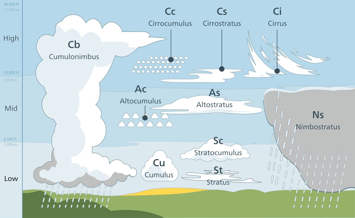
| Band | EASA texts, temperate latitudes | FAA | Genera |
|---|---|---|---|
| High | 16,500 to 45,000 ft (5 to 13 km) | Above about 20,000 ft | Cirrus (Ci), cirrocumulus (Cc), cirrostratus (Cs) |
| Medium (FAA: middle) | 6,500 to 23,000 ft (2 to 7 km) | Bases about 6,500 to 20,000 ft AGL | Altocumulus (Ac), altostratus (As); nimbostratus (Ns) in EASA texts |
| Low | Surface to 6,500 ft (2 km) | Below 6,500 ft | Stratus (St), stratocumulus (Sc); nimbostratus in FAA texts |
| Heap cloud | Base in the low band, tops through all three bands | Vertical development family | Cumulus (Cu), cumulonimbus (Cb); the FAA adds towering cumulus |
The bands overlap and are higher in the tropics than in temperate latitudes. Each genus is filed in one band whatever its depth, and not always the band its base lies in: nimbostratus is classed as medium in EASA texts although its base normally sinks into the low band, so it spans at least two bands, while FAA texts class it as low. Cumulus and cumulonimbus are the only genera that can extend through all three, and cumulonimbus tops often reach the tropopause.
Exam tip: The prefix gives the band: cirro- is high and alto- is medium. Nimbostratus crosses at least two bands; cumulus and cumulonimbus can cross all three.
Cumuliform and stratiform cloud
Classified by shape, clouds take three forms:
- Stratiform cloud is layered, of large horizontal and small vertical extent. It forms in stable air that is lifted gently, as over a warm front or by turbulence under an inversion.
- Cumuliform cloud is heaped, of large vertical and small horizontal extent. It forms in unstable air, and its presence shows vertical motion.
- Cirriform cloud is fibrous, wispy or hair-like, made only of ice crystals and found only at high levels.
The form also decides the precipitation. Layer cloud gives continuous precipitation, without a break for an hour or more, or intermittent precipitation; nimbostratus is the classic continuous rain cloud. Heap cloud gives showers, which start and stop suddenly and can be heavy. Drizzle comes from stratus, and hail only from cumulonimbus.
High cloud: cirrus, cirrocumulus, cirrostratus
High clouds are made entirely of ice crystals, so they produce nil or only trace icing.
- Cirrus (Ci): detached white filaments, tufts or bands with a fibrous look. Cirrus spreading and thickening from one direction is often the first sign of a warm front, and wisps blowing at right angles to the lower clouds can reveal a jet stream, with a risk of clear air turbulence near it.
- Cirrocumulus (Cc): a thin, white patch or sheet made of very small grains or ripples, without shading.
- Cirrostratus (Cs): a transparent, whitish veil, fibrous or smooth, covering part or all of the sky. It often produces a halo. In middle latitudes it usually indicates an approaching warm front; in the tropics it is also associated with tropical revolving storms.
Middle cloud: altocumulus and altostratus
- Altocumulus (Ac): white or grey patches, sheets or layers of rounded masses or rolls, made mainly of water droplets, supercooled when below 0 °C. Icing is usually light. Two species matter to pilots. Altocumulus lenticularis, lens-shaped and smooth-edged, forms on the crests of mountain waves downwind of high ground; the air inside the lenticular is smooth, but the air around it can be severely turbulent. Altocumulus castellanus has turrets rising from a common base. It shows instability at medium levels and often heralds showers and thunderstorms, especially when seen on a summer morning.
- Altostratus (As): a greyish or bluish sheet, fibrous or uniform, covering all or part of the sky. Where it is thinnest the sun shows as if through ground glass, but there is no halo, which distinguishes it from cirrostratus. It contains supercooled droplets and ice crystals, gives light icing and light continuous precipitation, and ahead of a warm front it thickens and lowers into nimbostratus.
Stratus, stratocumulus and nimbostratus
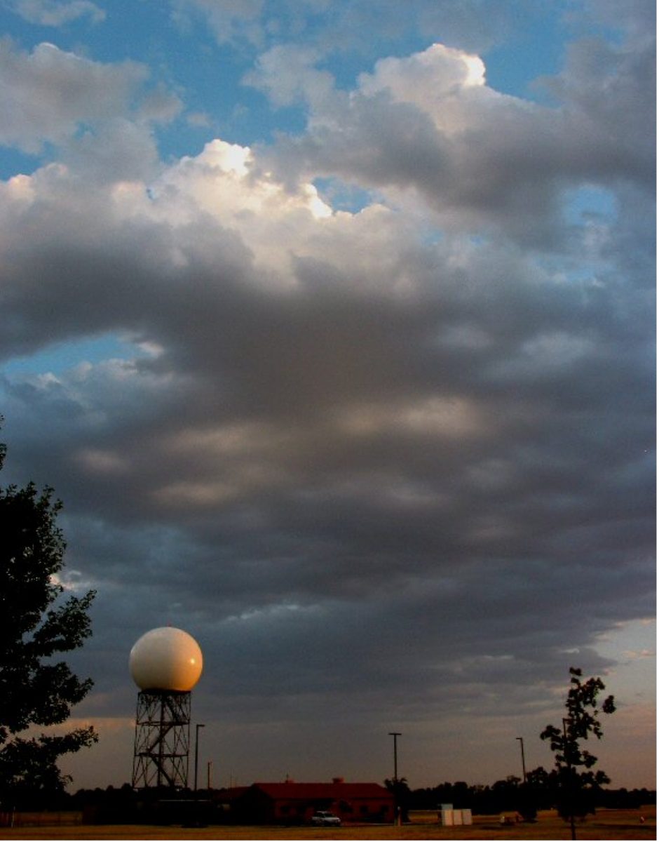
- Stratus (St): a generally grey layer with a fairly uniform base, which may give drizzle. Visibility inside stratus is the poorest of any cloud, typically less than 30 m. It forms by turbulence beneath an inversion, by the lifting of fog or by moist air crossing a cold surface, and where its base lies below the hilltops it covers them as hill fog. Icing is light.
- Stratocumulus (Sc): a grey or whitish layer or patches of rounded masses or rolls, usually with darker parts. It forms beneath an inversion by mixing in the friction layer, which gives it a flat top, and it is typical of the warm sector of a depression. Icing is light to moderate, and can be severe over mountains.
- Nimbostratus (Ns): a thick, dark grey rain cloud, dense enough to hide the sun, with a low, ragged base. It gives prolonged continuous rain or snow, mainly at warm fronts and occlusions, with moderate to severe icing and turbulence. Rain falling from it into sub-zero air below can freeze on impact, and at an occlusion cumulonimbus may be embedded in it, hidden from view.
Convective cloud: cumulus and towering cumulus
Cumulus (Cu) consists of detached, dense clouds with sharp outlines and flat bases, developing upwards in rounded domes. It shows vertical motion in unstable air, usually driven by surface heating, and its flat base marks the condensation level. The critical temperature is the surface temperature at which thermals first reach that level; below it no cumulus forms. Over land, cumulus formed by surface heating dissipates at night when the heating stops.
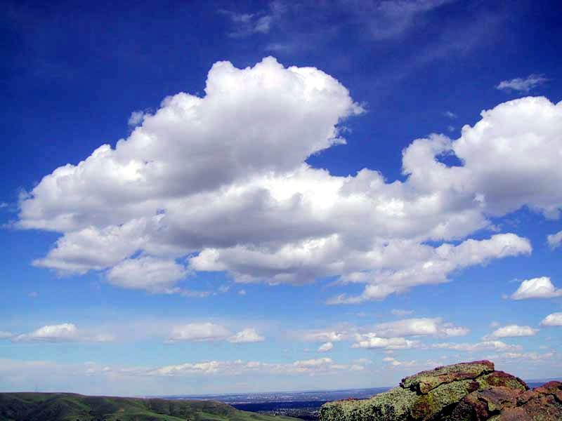
Towering cumulus (TCU), the cumulus congestus of the cloud atlas, is cumulus of great vertical extent with bulging, cauliflower tops. It is a stage in the growth of a cumulonimbus, holds strong updraughts, turbulence and large supercooled droplets, and gives showers. TCU and cumulonimbus (CB) are the only cloud types named in METAR and TAF cloud groups, as in BKN025TCU, and either one at any height rules out CAVOK (see cloud cover and ceiling).
Cumulonimbus (Cb) is the final stage: a heavy, dense cloud of great vertical extent whose upper part has glaciated and often spreads into an anvil. It produces thunderstorms, hail, severe turbulence, severe icing and windshear, and is covered in thunderstorms.
Glaciation and optical effects
Glaciation is the change of a cloud, or part of it, from liquid droplets to ice crystals. Because freezing nuclei are scarce, droplets stay liquid well below 0 °C: supercooled droplets are common down to about −20 °C, and small ones survive to about −40 °C, below which a cloud is almost entirely ice. Between these temperatures droplets and ice crystals coexist, and because the saturation vapour pressure over ice is lower than over water, the crystals grow at the expense of the droplets. This Bergeron process is the main way cold cloud produces precipitation (see humidity and water vapour).
Glaciation can be seen. Water cloud has hard, sharp, cauliflower outlines; ice cloud looks soft, fibrous or streaky. When the hard top of a towering cumulus turns fibrous, it has glaciated and the cloud has become a cumulonimbus. For airframe icing, glaciation is good news: ice crystals bounce off the airframe rather than sticking. High concentrations of ice crystals near convective cells can still affect engines and air data probes, however (see airframe icing).
Optical effects help identify the cloud:
- A halo, a ring of light around the sun or moon, commonly 22° from it, is produced by refraction through ice crystals. It identifies ice cloud, normally cirrostratus.
- A sun seen as through ground glass, with no halo, identifies altostratus.
- Virga, streaks of precipitation hanging below a cloud base and evaporating before they reach the ground, shows dry air beneath the cloud. The evaporation chills the air and can drive strong downdraughts; beneath convective cloud it is a warning of possible microbursts (see windshear and microbursts).
Flight conditions in each cloud type
| Cloud | Made of | Icing (EASA texts) | What to expect |
|---|---|---|---|
| Ci, Cc, Cs | Ice crystals | Nil or trace | Clear air turbulence possible near jet streams |
| As | Supercooled droplets and ice crystals | Light | Light continuous precipitation; long periods in cloud |
| Ac | Mainly water droplets, supercooled below 0 °C | Light | Lenticularis marks mountain waves; castellanus marks instability |
| Ns | Water, supercooled droplets, ice crystals and snow | Moderate to severe | Continuous precipitation, poor visibility, moderate to severe turbulence, possible embedded Cb |
| St | Water droplets, supercooled below 0 °C | Light | In-cloud visibility below 30 m; drizzle; hill fog |
| Sc | Water droplets, supercooled below 0 °C | Light to moderate; severe over mountains | Flat top under an inversion |
| Cu, TCU | Water droplets, supercooled above the freezing level | Moderate to severe | Turbulence and showers growing with vertical development |
| Cb | Water, supercooled water, ice and hail | Moderate to severe | Severe turbulence, hail, lightning and windshear: avoid |
The difference in icing comes from the air. In cumuliform cloud strong updraughts hold a high liquid water content and large droplets, which freeze slowly and form clear ice, but a pilot usually crosses a cell quickly. In stratiform cloud the droplets are smaller and mostly form rime, and the icing is lighter, but it can continue over long distances.

Frequently asked questions
What are the ten cloud types?
The international classification has ten genera. The high clouds are cirrus, cirrocumulus and cirrostratus; the medium clouds are altocumulus and altostratus, with nimbostratus classed as medium in EASA texts although its base usually lies low, and as low cloud in FAA texts; the low clouds are stratus and stratocumulus; and cumulus and cumulonimbus have bases in the low band and tops that can reach any level. FAA material groups cumulus, towering cumulus and cumulonimbus as clouds of vertical development.
What is the difference between stratiform and cumuliform cloud?
Stratiform cloud is layered, wide and shallow, and forms when stable air is lifted gently, as ahead of a warm front or under an inversion. It gives continuous or intermittent precipitation, poor visibility and generally light turbulence. Cumuliform cloud is heaped, tall and narrow, and forms in unstable air. It gives showers, turbulence and, in its larger forms, clear ice, hail and thunderstorms.
Which clouds give the worst airframe icing?
EASA texts rate icing as moderate to severe in cumulus, cumulonimbus and nimbostratus, light to moderate in stratocumulus, severe over mountains, light in altocumulus, altostratus and stratus, and nil or trace in the ice-crystal cirrus family. Heap clouds are worst because strong updraughts hold large supercooled droplets, which form clear ice. Layer cloud mostly gives rime, but it can extend over long distances.
What does altocumulus castellanus indicate?
Altocumulus castellanus is medium-level cloud with small turrets rising from a common base. The turrets show that the air at that level is unstable and already convecting. Seen in the morning, especially in summer, it often means that once surface heating adds lift from below, showers and thunderstorms will develop in the afternoon.
What causes a halo around the sun or moon?
A halo is a ring of light, commonly at 22 degrees from the sun or moon, produced by light refracted through ice crystals. It therefore shows that the cloud is made of ice, and it is typical of cirrostratus. In middle latitudes cirrostratus spreading across the sky is often the first sign of an approaching warm front. Altostratus shows the sun as if through ground glass but gives no halo.
Test yourself on Cloud Formation and Types
The v1prep banks cover this topic in Meteorology (050), with a worked explanation for every answer. EASA ATPL, PPL, IR and CPL, the FAA written tests and A320/B737 type ratings.
Start practising →Sources and further reading
- World Meteorological Organization, International Cloud Atlas
- FAA-H-8083-28B, Aviation Weather Handbook
- FAA Pilot's Handbook of Aeronautical Knowledge (FAA-H-8083-25), Chapter 12, Weather Theory
- EASA, Explanatory Note to ED Decision 2018/001/R, Part-FCL theoretical knowledge learning objectives
- Met Office, Clouds
- FAA Advisory Circular AC 91-74B, Pilot Guide - Flight in Icing Conditions
Library articles are written for study and exam preparation. They do not replace your aircraft's approved documentation, your operator's procedures or the regulations themselves.