True, Magnetic and Compass Direction
Directions in navigation are angles measured clockwise from a reference north: true north along the geographic meridian, magnetic north along the local magnetic field, or compass north as shown by the aircraft's compass. Variation is the angle between true and magnetic north, deviation the angle between magnetic and compass north.
Every direction in air navigation is an angle measured clockwise from north, from 000° to 359°. The difficulty is that there are three norths. True north lies along the geographic meridian, magnetic north is where the Earth's magnetic field points, and compass north is where the compass in a particular aircraft actually points. A heading, track or bearing means little until its reference is known, which is why it is written with a suffix: 270°T, 270°M or 270°C.
Charts are drawn and routes measured in true, but runways, VOR radials, airways, ATC headings and cruising levels are magnetic, and the pilot steers by a compass. Converting between the three with variation and deviation is one of the first skills of navigation and a staple of EASA subject 061 and the FAA knowledge tests.
True, magnetic and compass north
True north is the direction along the meridian towards the geographic North Pole, where the Earth's axis of rotation meets the surface. The latitude and longitude graticule is built on it, and great circles, rhumb lines and chart tracks are measured from it (see the Earth: shape, coordinates and great circles).
Magnetic north is the direction in which the horizontal component of the Earth's magnetic field points at a given place. The vertical plane containing that direction is the magnetic meridian. Magnetic north is a local direction, not a spot on the map: the magnetic poles do not coincide with the geographic ones and they move, and the field is irregular (see terrestrial magnetism).
Compass north is the direction in which the magnet system of the aircraft's own compass settles. The aircraft's ferrous structure and electrical circuits pull it slightly away from magnetic north by an amount that changes with heading (see magnetic compass).
| Angle | Between | Property of | Named |
|---|---|---|---|
| Variation | True and magnetic north | The place (and slowly, the date) | East or west |
| Deviation | Magnetic and compass north | The individual aircraft and its heading | East (+) or west (−) |
Only deviation is an error, caused by the aircraft itself. Variation would exist with no compass on board.
Magnetic variation
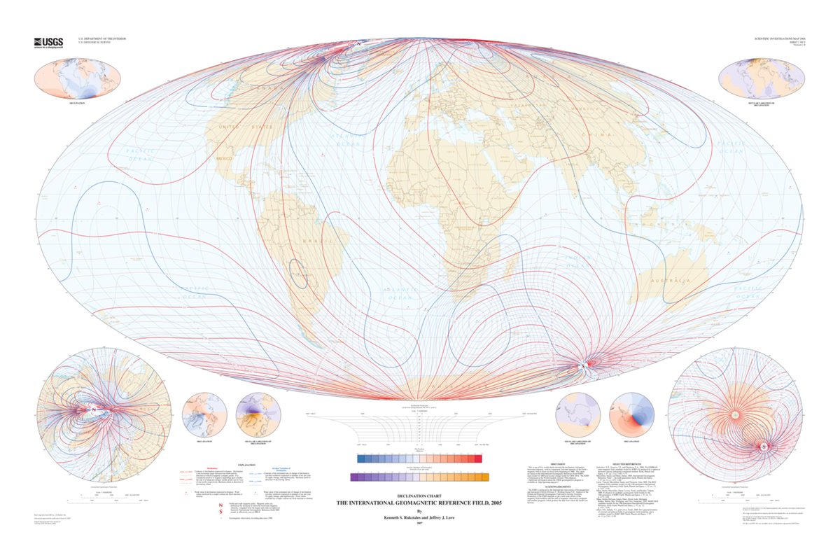
Magnetic variation is the angle, measured in the horizontal plane, between the true meridian and the magnetic meridian at a place. Geophysicists call it declination, as does French usage (déclinaison magnétique). It is named east when magnetic north lies east of true north and west when it lies west. With 7°W variation, magnetic north is 7° west of true north, so a true heading of 090° is a magnetic heading of 097°.
Variation changes with position. Near the magnetic poles it can take any value up to 180°, and there it also changes rapidly over short distances. It changes with time as the Earth's field slowly drifts, so charts state the variation together with the year it applies to, such as "VAR 1°E (2020)" on a French visual approach chart. ICAO Annex 4 asks for the annual change as well on aerodrome charts; France notifies in its AIP that it omits that figure, publishes a change of variation in AD 1.3 and AD 2.2 within six AIRAC cycles, and updates its charts within three years.
Aircraft systems carry their own model of the field. An inertial reference system computes true heading and derives magnetic heading by applying variation from a stored table, such as one built from the World Magnetic Model; the Boeing 737's IRS, for example, stores variation between 82°N and 82°S.
Isogonals and the agonic line
An isogonal, called an isogonic line in FAA usage, is a line on a chart joining places of equal variation. On FAA sectional charts isogonic lines are dashed magenta lines labelled with the value, such as 5°E; European VFR charts show them as dashed lines labelled with values such as 2°W. Along the route the pilot reads off the variation to apply, interpolating between lines.
The agonic line is the isogonal along which variation is zero, so that true and magnetic north coincide. It is the only isogonal with a name of its own, and crossing it the variation changes between east and west. Another family of lines is easily confused with these: isoclinals join places of equal magnetic dip, and the aclinic line, of zero dip, is the magnetic equator.
VOR stations are aligned with magnetic north at their site, so their radials are magnetic, and the compass roses printed around them on charts are turned away from the meridians by the local variation. A radial is converted to true with the variation at the station; a bearing measured at the aircraft, such as an ADF bearing, with the variation at the aircraft. An aircraft on a QDR of 150°M from a VOR where the variation is 10°E is on a true bearing from it, the QTE, of 160°T.
Headings, courses, tracks and bearings
| Term | Meaning | Common forms |
|---|---|---|
| Heading (HDG) | Direction in which the aircraft's longitudinal axis points | True heading (TH), magnetic heading (MH), compass heading (CH) |
| Track (TR) | Direction of the aircraft's path over the ground | Required track, track made good, magnetic track |
| Course (FAA) | Intended direction of flight | True course (TC), magnetic course (MC) |
| Bearing (BRG) | Direction of one point from another | True bearing, magnetic bearing (MB), relative bearing |
Heading and track differ by the drift caused by the wind (see triangle of velocities). The true course is measured on the chart with a protractor; on a Lambert chart it is measured at the meridian nearest the middle of the leg, because meridians converge and a straight line's true direction changes along it.
A bearing is measured clockwise from north to the line joining two points. A relative bearing is measured from the aircraft's nose instead, and magnetic heading + relative bearing = magnetic bearing to the station, subtracting 360° when the sum exceeds it. The Q codes name the four combinations: QDM is the magnetic bearing to a station, QDR the magnetic bearing from it, QUJ the true bearing to it and QTE the true bearing from it.
The semicircular cruising-level rules are based on magnetic track, not heading: 000° to 179° take odd levels, 180° to 359° even ones, under SERA and, by magnetic course, under 14 CFR 91.159 and 91.179. A wind correction that takes the heading across 180° does not change the level.
Converting with CDMVT
Working from the compass towards true, the chain is:
Compass ± Deviation = Magnetic ± Variation = True
At each step easterly corrections are added and westerly ones subtracted. The order of the letters gives the mnemonic CDMVT, often remembered as "Cadbury's Dairy Milk Very Tasty". In EASA texts easterly deviation is called plus and westerly minus for the same reason: magnetic = compass + east deviation.
| Compass | Deviation | Magnetic | Variation | True |
|---|---|---|---|---|
| 305° | 3°W | 302° | 6°E | 308° |
| 025° | 5°E (+5) | 030° | 10°W | 020° |
| 095° | 2°W | 093° | 6°E | 099° |
Deviation is taken from the compass deviation card beside the instrument, filled in after a compass swing. It is usually laid out as "for" a magnetic heading, "steer" a compass heading. A card reading "For 090 steer 095" means the compass must read 095° to fly 090°M: the compass reads more than magnetic, so the deviation there is 5°W. Between entries the pilot interpolates: with "for 060 steer 062" and "for 090 steer 092", 070°M is flown by steering 072°C.
Warning: sign conventions differ. FAA problems often call the correction added to the magnetic heading to get the compass heading "plus", so "for 060 steer 062" becomes "+2°", which EASA texts would call 2°W, or minus. Reading the card's for and steer figures directly avoids the trap.
East is least, west is best
Planning runs the other way, from the chart's true track to the compass heading to steer, and the signs reverse: subtract easterly, add westerly. The memory aids say the same thing:
- Variation east, magnetic least; variation west, magnetic best: with westerly variation the magnetic figure is the larger.
- Deviation east, compass least; deviation west, compass best.
- Together: east is least, west is best, going from true towards compass.
Examples: a true heading of 270° with 8°W variation is 278°M. A true heading of 073° with 8°W variation is 081°M; with 2°E deviation the compass heading is 079°C. A true heading of 359° with 2°W variation is 001°M, not 361°. Ignoring wind, a true track of 250° under a chart header of VAR 2°E is 248°M, and with 1°W deviation the compass heading is 249°C.
FAA problems often write the whole planning chain with the wind included:
TC ± VAR = MC; MC ± WCA = MH; MH ± DEV = CH
The wind correction angle is normally worked out with the true course, because forecast winds are true, but corrections simply add, so applying it before or after the variation gives the same heading. Deviation comes last because the card is entered with the magnetic heading actually flown. In one sentence: going down from true to compass, add west and subtract east; coming back up, do the opposite.
Exam tip: most wrong answers come from applying a correction in the wrong direction. Check the answer's size: with west variation the magnetic figure must be larger than the true one.
Choosing a true or magnetic reference
Magnetic directions are used wherever a pilot flies by compass or heading indicator:
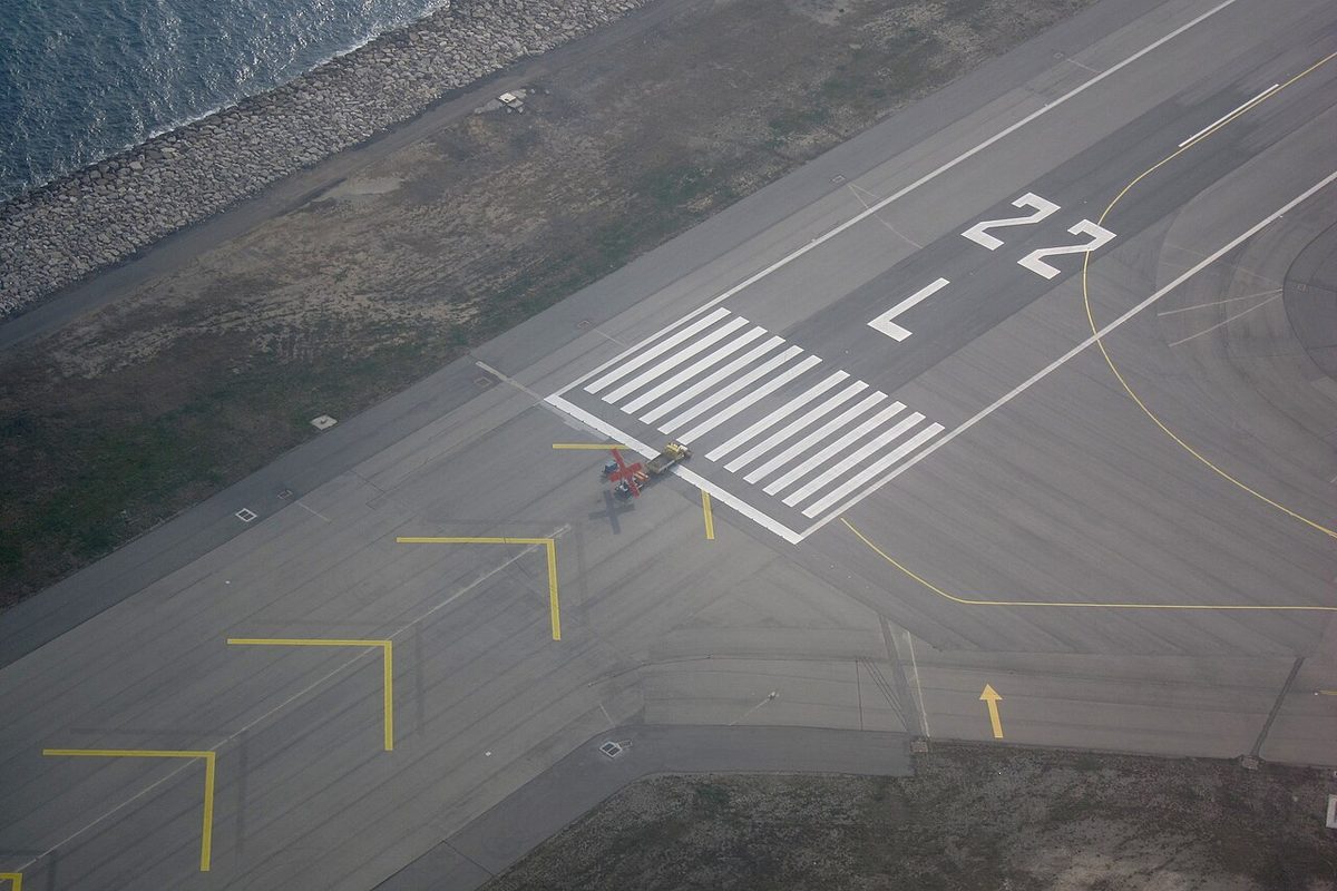
- runway designators, which are the magnetic direction of the centreline divided by 10 and rounded, so 268°M becomes runway 27;
- VOR radials, airway and route tracks, SID and STAR tracks and ATC headings;
- the surface wind given by the tower or ATIS, so that it can be compared with the runway;
- the semicircular cruising-level rules.
True directions are used for chart plotting, computer flight plans, METAR, TAF and upper wind reports, and great-circle calculations. The FAA's AIM explains that each leg of an instrument procedure is first computed along a true track, and a variation value is then applied to publish a magnetic course. Most PBN systems navigate by reference to true north and show magnetic courses only for the pilot, applying their own variation values, so a displayed course can differ slightly from the charted one. On FAA RNAV routes the charted magnetic reference bearing (MRB) is found by applying the variation at the waypoint to the true course.
Airliner displays can be switched between the two references; the Boeing 737 heading scale shows MAG or TRU. Where the magnetic field becomes unreliable, near the magnetic poles, true or grid references take over. In Canada's Northern Control Area VOR beacons are aligned with true north, and when all its inertial units use the same variation table, the Airbus A320's inertial reference system does not provide valid magnetic heading north of 73°N between 90°W and 120°W, north of 82°N or south of 60°S (see polar and grid navigation).
Frequently asked questions
What is the difference between true north and magnetic north?
True north is the direction along the meridian towards the geographic North Pole, the reference on which charts are drawn. Magnetic north is the direction in which the horizontal part of the Earth's magnetic field points at a given place, the reference a compass uses. The angle between them is the magnetic variation. It depends on where you are, changes slowly over the years, and is printed on charts as isogonals.
What does east is least, west is best mean?
It is the rule for converting a true direction to magnetic, or a magnetic direction to compass. Easterly variation or deviation is subtracted, so the magnetic or compass figure is the smaller one, and westerly is added, so it is the larger. A true heading of 270 degrees with 8 degrees west variation is 278 degrees magnetic. Converting the other way, from compass towards true, the signs reverse.
How do you convert a compass heading to a true heading?
Follow CDMVT, compass, deviation, magnetic, variation, true, adding easterly and subtracting westerly corrections at each step. A compass heading of 305 degrees with 3 degrees west deviation gives 302 degrees magnetic; with 6 degrees east variation that becomes 308 degrees true. Deviation comes from the deviation card for the heading being flown, and variation from the chart for the aircraft's position.
What are isogonic lines and the agonic line?
Isogonic lines, called isogonals in European texts, join places with the same magnetic variation. On FAA sectional charts they are dashed magenta lines labelled with the variation, such as 5 degrees E. The agonic line is the isogonal along which variation is zero, so that true and magnetic north coincide there. Lines of equal magnetic dip are a different family, the isoclinals.
Why are runway numbers and VOR radials magnetic while METAR winds are true?
Runways, VOR radials, airways and ATC headings are magnetic so that a pilot can fly them directly with a compass or heading indicator. Meteorological reports and forecasts such as METARs, TAFs and upper wind charts are distributed widely and used on charts drawn to true north, so they give wind directions in degrees true. The wind passed by the tower or ATIS is magnetic, to match the runway.
Test yourself on True, Magnetic and Compass Direction
The v1prep banks cover this topic in General and Radio Navigation (061/062), with a worked explanation for every answer. EASA ATPL, PPL, IR and CPL, the FAA written tests and A320/B737 type ratings.
Start practising →Sources and further reading
- FAA Pilot's Handbook of Aeronautical Knowledge (FAA-H-8083-25), Chapter 8 (magnetic compass) and Chapter 16 (Navigation)
- FAA Aeronautical Information Manual, Chapter 1 Section 1 (1-1-17, impact of magnetic variation on PBN systems)
- FAA Aeronautical Information Manual, Chapter 5 Section 3 (5-3-4, magnetic reference bearing)
- FAA Aeronautical Chart Users' Guide
- AIP France, GEN 1.7, Differences from ICAO Standards, Recommended Practices and Procedures (Annex 4, magnetic variation)
- NOAA National Centers for Environmental Information, World Magnetic Model
- EASA, Explanatory Note to ED Decision 2018/001/R, Part-FCL theoretical knowledge learning objectives (061 General Navigation)
Library articles are written for study and exam preparation. They do not replace your aircraft's approved documentation, your operator's procedures or the regulations themselves.