Pressure Systems
A pressure system is an organised pattern of sea-level pressure shown by the isobars on a weather chart: a depression (low), an anticyclone (high), or one of the intermediate shapes, the trough, ridge and col. Each has its own wind circulation, vertical motion and typical weather.
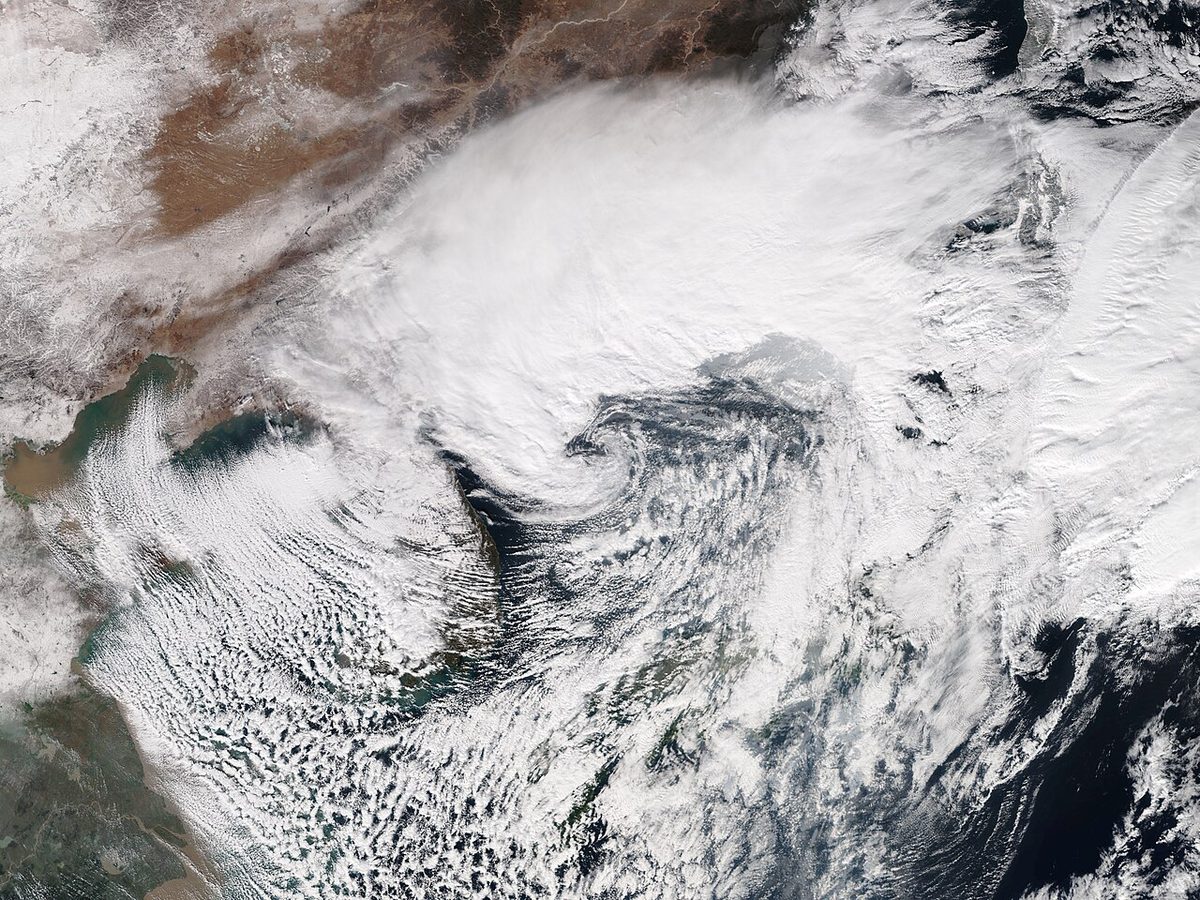
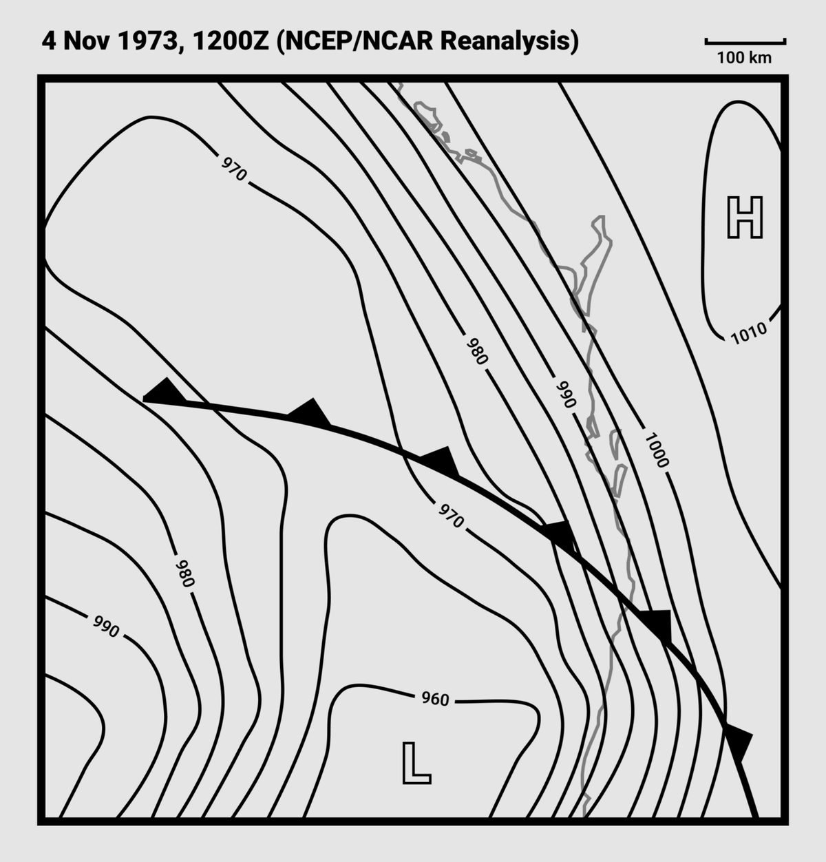
A chart of mean sea-level pressure reads like a relief map. Where the pressure is lower than all around, there is a depression, or low; where it is higher, an anticyclone, or high. Between them lie the trough, a valley running out from a low, the ridge, a spur running out from a high, and the col, the saddle between two of each. These pressure systems set the wind and the vertical motion of the air, which largely decides whether the sky is cloudy and wet or clear and hazy.
Recognising the pattern is the quickest way to anticipate a day's flying: frontal cloud and strong winds in a deepening low, fog or haze trapped under a winter high, afternoon thunderstorms in a summer col.
Highs, lows and pressure patterns
Surface charts show pressure reduced to mean sea level, usually as QFF, so that stations at different elevations can be compared. Lines joining places of equal pressure are isobars. On synoptic charts the pressure normally lies between about 950 and 1050 hPa, although extremes fall well outside that range: the lowest sea-level pressure on record is 870 hPa, in the eye of Typhoon Tip in 1979 (see atmospheric pressure).
Above the friction layer the wind blows almost along the isobars. Buys Ballot's law gives its sense: in the northern hemisphere, stand with your back to the wind and low pressure is on your left; in the southern hemisphere it is on your right. Air therefore circulates anticlockwise round a northern hemisphere low and clockwise round a high, and the reverse in the south. Circulation in the same sense as a low is called cyclonic; in the sense of a high, anticyclonic.
The closer the isobars, the steeper the pressure gradient and the stronger the wind. Curvature modifies the balance: for the same isobar spacing, the gradient wind round a low is lighter than the geostrophic value and round a high it is stronger. Within the friction layer, which usually extends 2,000 to 3,000 ft above the surface, the wind is slowed and turned to blow partly across the isobars towards low pressure (see wind forces and the geostrophic wind).
| System | Isobar pattern | Circulation (northern hemisphere) | Vertical motion |
|---|---|---|---|
| Depression (low) | Closed, lowest pressure at the centre, often closely spaced | Anticlockwise | Surface convergence, ascent |
| Anticyclone (high) | Closed, highest pressure at the centre, widely spaced | Clockwise | Subsidence, surface divergence |
| Trough | V-shaped extension of a low | Cyclonic curvature | Convergence, ascent |
| Ridge | Rounded extension of a high | Anticyclonic curvature | Subsidence |
| Col | Saddle of almost level pressure between two highs and two lows | Light and variable | Little organised motion |
| Secondary depression | Smaller low inside a larger one's circulation, not always closed | Cyclonic round the primary | Ascent |
FAA material speaks of low-pressure and high-pressure systems and often calls a mid-latitude low a cyclone; the EASA and British term is depression.
Convergence, divergence and vertical motion
In a depression, friction turns the surface wind inward across the isobars and the air converges. With nowhere to go but up, it rises through the troposphere and diverges, spreading outward, near the top. An anticyclone works the other way round: air converges aloft, sinks, and diverges outward at the surface. The slow sinking of air over a wide area is subsidence.
Surface pressure is the weight of the air column, so the balance between the two decides how a system develops. A low deepens, its central pressure falling, when divergence aloft removes more air from the column than convergence near the surface brings in. It fills, its central pressure rising, when the inflow wins. A high builds when convergence aloft exceeds the outflow at the surface and weakens, or collapses, when it does not. The divergence aloft is organised by the upper westerlies and their jet streams, which is why the development of a surface low is tied to the flow pattern above it (see jet streams).
The vertical motion explains the weather. Rising air cools adiabatically, reaches its dew point and forms cloud; convergence is one of the recognised lifting mechanisms, alongside convection, orographic, frontal and turbulent uplift. Sinking air warms adiabatically, its relative humidity falls and cloud evaporates. Subsidence often ends above the surface layer in a subsidence inversion (see temperature inversions).
Exam tip: Low: convergence at the surface, ascent, divergence aloft. High: convergence aloft, subsidence, divergence at the surface. A trough behaves like a low and a ridge like a high.
Depressions: deepening and filling
Most mid-latitude lows are polar front depressions, formed where warm, moist subtropical air meets cold polar air; their fronts and life cycle are covered in air masses and fronts. ATPL texts put the growth of such a low, from formation to its lowest central pressure, at about four days; the decay as it fills can take ten days or more, after which another system absorbs it. Filling usually follows occlusion, once the warm air that fed the system has been lifted off the surface.
Frontal depressions move quickly, generally from west to east, steered by the warm-sector isobars while the warm sector is open. In the northern hemisphere their track tends to curve anticlockwise. They form in families along the polar front, new members usually developing as secondary depressions at the point of occlusion or at the end of a trailing cold front. A secondary lies within the circulation of the primary, moves cyclonically round it, and can deepen to become more active than its parent.
Deepening brings a tighter gradient, stronger winds and more active weather; a deep low can bring gales, defined as a mean wind above 33 kt or gusts above 42 kt. It also means falling QNH: flying towards it without resetting the subscale, the altimeter over-reads and the aircraft is lower than indicated, the rule remembered as "from high to low, look out below" (see altimeter settings).
Thermal, orographic and polar lows
Not every low grows on a front. Lows that form without one are non-frontal depressions; ATPL texts describe thermal, orographic and polar lows, and the tropical revolving storm.
A thermal depression, or thermal low, forms by surface heating, typically over land in summer. The heated column expands and lifts the pressure surfaces above it; the higher pressure aloft drives air outward at height, the column loses mass, and the surface pressure falls, drawing air in cyclonically at low level. Most thermal lows are shallow and weaken with height. In unstable air, though, they can be active up to the tropopause, with cumulus, cumulonimbus and thunderstorms. On a continental scale, the summer thermal low becomes the monsoon low, such as the Baluchistan Low over Pakistan (see global circulation and climate). In winter, thermal lows also form where cold air from the Siberian High flows over the relatively warm Mediterranean, above all in the central and eastern basin.
An orographic depression, or lee low, forms on the lee side of a mountain range when air is forced over it. The classic case is the Genoa low, over the Gulf of Genoa in the lee of the Alps. Genoa lows develop along the Mediterranean front in winter and bring much of the region's winter rain and wind. The weather of a lee low depends on the air involved: dry, stable air gives föhn conditions; moist air gives cumulus and cumulonimbus showers; and a cold front breaking over the range can bring heavy cumulonimbus with line squalls. High pressure over central France and a low over the Gulf of Genoa together drive the mistral down the Rhône valley (see local winds).
A polar low, called a polar air depression in some ATPL texts, forms in winter when arctic maritime air moves south over a warmer sea. Heated from below, the air becomes strongly unstable, and a small, intense low develops with cumulus, cumulonimbus and heavy showers, sometimes with secondary cold fronts. It must not be confused with a polar front depression, which forms on the boundary between polar and tropical air.
Anticyclones: warm, cold and blocking
An anticyclone has higher pressure at its centre and more widely spaced isobars than a depression, so its winds are generally light. It moves slowly and can persist in one area for long periods.
- A warm anticyclone is warm through a deep layer. The subtropical highs, such as the Azores High, are the main examples: permanent features over the subtropical oceans, maintained by air that converges near the tropopause, where the Hadley and Ferrel cells meet, and sinks. Because pressure falls with height more slowly in warm air than in cold, a warm high extends through the troposphere.
- A cold anticyclone forms because cold, dense air at the surface raises the pressure. Cold highs are permanent over the poles and seasonal over the continents in winter, the Siberian High being the strongest, with a mean of about 1035 hPa in January. For the same reason in reverse, pressure falls quickly with height in the cold air, so a cold high is shallow.
- A temporary cold anticyclone is a ridge of high pressure in the cold air between two frontal depressions. Because the lows move quickly, its fine weather lasts at most about 24 hours before the next system arrives.
- A blocking anticyclone is a persistent high that stops frontal depressions moving eastward as usual, forcing them to take more northerly tracks in the northern hemisphere. It can last for weeks, and is often an extension of a subtropical high or, over Europe in winter, of the Siberian High.
Subsidence dominates anticyclonic weather. In summer it gives clear or fair-weather skies, haze and sea breezes on sunny coasts. In winter the subsidence inversion acts as a lid: moisture, smoke and dust accumulate beneath it and visibility worsens the longer the high persists; with a sheet of stratocumulus also trapped under the inversion, the result is the dull, murky condition called anticyclonic gloom. Radiation fog that forms on clear nights may defeat a weak winter sun, and an inland valley can stay fog-bound all day (see fog).
Troughs, ridges and cols
A trough is an extension of a low, drawn with V-shaped isobars. It has the vertical motion of a depression: convergence at the surface and ascent. Fronts lie in troughs, but non-frontal troughs are common too, especially in cold, unstable air. Crossing a well-marked trough line, expect a sharp veer of the wind in the northern hemisphere and a line of cumulus, showers or thunderstorms, since the isobars kink abruptly and the air is forced to rise along the axis. In the upper air, sharply curved troughs produce stronger wind shear and clear air turbulence than broad ridges (see turbulence).
A ridge, or ridge of high pressure, is an extension of a high, drawn with rounded isobars. It has anticyclonic vertical motion: convergence aloft, subsidence and surface divergence. Ridges suppress convection and bring fair weather and light winds, with a risk of radiation fog on clear nights. A ridge between two depressions is the temporary cold anticyclone described above.
A col is a region of almost level pressure between two highs and two lows. The gradient is so slack that the wind is light and variable, and cols tend to be slow-moving or static. With nothing to disperse moisture or pollution, autumn and winter cols bring poor visibility and fog. In summer the same stagnant, moist air is strongly heated by day, and thunderstorms are common by the afternoon.

Weather associated with each system
| System | Typical weather | Main concerns for the pilot |
|---|---|---|
| Frontal depression | Layer and frontal cloud, prolonged rain or snow, strong and gusty winds | Low ceilings, icing, embedded cumulonimbus, falling QNH, crosswinds |
| Thermal low, summer | Fine mornings, cumulus and thunderstorms by afternoon in unstable air | Convective turbulence, thunderstorms, density altitude |
| Polar low | Cumulus and cumulonimbus, heavy snow showers | Icing, turbulence, sudden drops in visibility |
| Anticyclone, summer | Clear skies or fair-weather cumulus, haze, sea breezes | Poor slant visibility in haze |
| Anticyclone, winter | Stratocumulus under the inversion, or clear nights with fog and frost | Persistent fog and low stratus, freezing fog, trapped pollution |
| Trough | Line of cumulus, showers or thunderstorms, sharp wind shift | Convection along the line, turbulence, change of drift |
| Ridge | Fair weather, light winds, subsidence | Radiation fog at night, haze below the inversion |
| Col | Light, variable winds; fog in winter, thunderstorms in summer | Fog that is slow to clear, afternoon storms |
Exam tip: Frontal depressions move rapidly, anticyclones move slowly and persist, and cols tend to stay put. A temporary cold anticyclone lasts about a day, a blocking anticyclone can last for weeks. Radiation fog needs a slack gradient, which is why anticyclones, ridges and cols all favour it.
Frequently asked questions
What is the difference between a depression and an anticyclone?
A depression is an area of low pressure with air converging at the surface and rising, so it brings cloud, precipitation and often strong winds; the air circulates anticlockwise in the northern hemisphere. An anticyclone is an area of high pressure with sinking air that warms and dries, widely spaced isobars and light winds; the air circulates clockwise in the northern hemisphere. Depressions usually move quickly, anticyclones slowly.
What weather is associated with a col?
A col is the region of almost level pressure between two highs and two lows. With so slack a gradient the wind is light and variable and nothing ventilates the surface layer. In autumn and winter that favours poor visibility and fog. In summer the same stagnant, moist air is strongly heated by day and often produces afternoon thunderstorms. Cols tend to be slow-moving or static.
What is a blocking anticyclone?
A blocking anticyclone is a large, persistent high that sits in the path of the westerlies and stops frontal depressions moving east as usual. In the northern hemisphere the lows are forced to take more northerly tracks around it. A block can last for weeks, bringing long settled spells, and is often an extension of a subtropical high or, over Europe in winter, of the Siberian high.
What is a thermal low?
A thermal low, or thermal depression, is a non-frontal low formed by strong surface heating, typically over land in summer. The heated column expands, raising the pressure surfaces aloft, so air flows outward at height and the surface pressure falls. Most thermal lows are shallow and weaken with height, but in unstable air they can produce cumulonimbus. The monsoon low over Pakistan is a very large example.
What does it mean when a depression is deepening or filling?
A depression deepens when its central pressure falls. The pressure gradient tightens, the winds strengthen and the weather usually becomes more active. It fills when its central pressure rises, the gradient slackens and the system decays, typically after the warm air has been lifted off the surface by occlusion. The equivalent terms for a high are building, when its pressure rises, and weakening or collapsing, when it falls.
Test yourself on Pressure Systems
The v1prep banks cover this topic in Meteorology (050), with a worked explanation for every answer. EASA ATPL, PPL, IR and CPL, the FAA written tests and A320/B737 type ratings.
Start practising →Sources and further reading
- FAA-H-8083-28B, Aviation Weather Handbook (Chapters 8, 9 and 11, atmospheric pressure, global circulations and the wave cyclone model)
- FAA Pilot's Handbook of Aeronautical Knowledge (FAA-H-8083-25), Chapter 12, Weather Theory
- Encyclopaedia Britannica, Anticyclone
- Encyclopaedia Britannica, Cyclone (meteorology)
- Flaounas et al. (2022), Mediterranean cyclones, Weather and Climate Dynamics 3, 173–208
Library articles are written for study and exam preparation. They do not replace your aircraft's approved documentation, your operator's procedures or the regulations themselves.