Global Circulation and Climate
The general circulation of the atmosphere is the planet-wide pattern of winds and pressure belts by which air carries heat from the tropics towards the poles. The three-cell model describes it in each hemisphere as a Hadley cell, a Ferrel cell and a polar cell.
The general circulation, or global circulation, is the large-scale pattern of winds and pressure that the atmosphere settles into as it carries heat from the tropics, which receive more energy from the sun than they radiate away, towards the poles, which lose more than they receive. Averaged over weeks, it produces belts of high and low pressure, the steady trade winds, the changeable westerlies of the middle latitudes and the seasonal monsoons.
For pilots the global picture explains why the weather of a region follows its seasons: why the tropics have daily thunderstorms, why deserts lie near 30° latitude, why frontal depressions march across Europe from the west, and why a long-haul route crosses a belt of towering cumulonimbus near the equator. It is the framework for the climatology questions of EASA ATPL meteorology.
The three-cell model
Temperature in the troposphere increases from the poles to the equator. On a non-rotating Earth the simplest response would be a single cell in each hemisphere: warm air rising at the equator, flowing poleward aloft, sinking over the cold pole and returning along the surface. This was George Hadley's original model.
The Earth's rotation breaks that single cell up. Air moving poleward in the upper troposphere is deflected by the Coriolis effect, to the right in the northern hemisphere and to the left in the southern, until it is flowing from the west rather than towards the pole. It cannot reach the pole, and the circulation of each hemisphere divides into three cells. William Ferrel's refinement gives the three-cell model taught today.
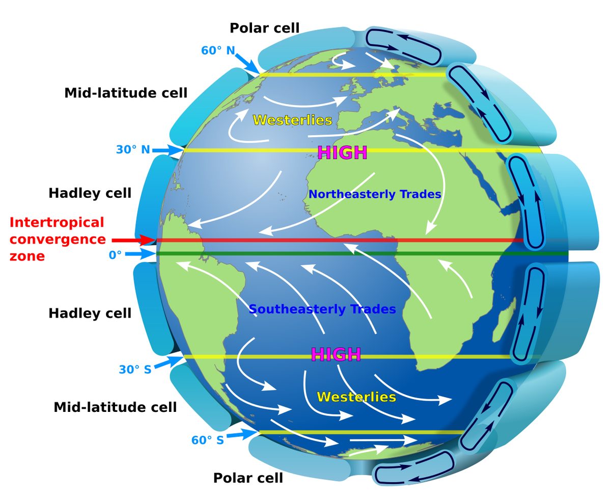
The Hadley cell is the tropical cell. Air heated near the equator rises at the intertropical convergence zone, flows poleward near the tropopause, and sinks in the subtropics at about 30° latitude. Air flowing poleward in its upper branch keeps its angular momentum about the Earth's axis and gains westerly speed, which feeds the subtropical jet stream near its poleward edge (see jet streams). Near the surface the air returns towards the equator as the trade winds.
The polar cell starts over the pole, where cold, dense air subsides into the permanent polar high. It spreads out at the surface towards lower latitudes, turned by the Earth's rotation into easterly winds, and meets milder air at the polar front, where it is lifted.
The Ferrel cell lies between them, in the middle latitudes. Its surface air flows poleward from the subtropical highs, turned into the westerlies, and rises at the polar front. It is not driven directly by heating like the other two; it is kept turning by the cells on either side. In reality the middle latitudes are dominated by travelling depressions and anticyclones, and the Ferrel cell describes only their average effect.
Upper winds reflect the temperature pattern. With cold air on the poleward side, the thermal wind aloft is westerly in both hemispheres; the tropical easterly jet of the northern summer is the notable exception.
Global pressure belts and semi-permanent systems
Where the cells meet at the surface, the model gives alternating belts of pressure:
| Belt | Approximate position | Air motion | Surface wind either side |
|---|---|---|---|
| Equatorial trough | Near the equator, following the sun | Rising, converging | Trade winds converge into it |
| Subtropical high | About 30° N and S | Subsiding | Trades on the equator side, westerlies on the pole side |
| Sub-polar low | Along the polar front | Rising | Westerlies meet polar easterlies |
| Polar high | Over the poles | Subsiding | Polar easterlies flow out |
The subtropical highs form because the upper branches of the Hadley and Ferrel cells converge near the tropopause over the subtropics, and the surplus air sinks. These warm anticyclones are permanent over the subtropical oceans; the Azores High in the North Atlantic is the one that most affects Europe and is the source of its tropical maritime air (see pressure systems).
Land and sea break the belts into cells that strengthen, weaken and even reverse with the seasons, because continents heat and cool far more than oceans. ATPL texts quote typical January and July values for the main semi-permanent systems of the northern hemisphere:
| System | January (northern winter) | July (northern summer) |
|---|---|---|
| Icelandic Low | About 1000 hPa | Less deep and more dispersed |
| Aleutian Low | About 1000 hPa | Disappears |
| Siberian High | About 1035 hPa, the strongest cold high | Replaced by low pressure over Asia |
| Baluchistan Low | Absent | Large thermal low centred over Pakistan |
| Azores High and Pacific High | About 1020 hPa each | Permanent subtropical highs |
| North American High | About 1020 hPa | Replaced by low pressure |
The Icelandic and Aleutian lows are not single storms but the average of the many depressions that pass through those regions. The Siberian High is a cold anticyclone, built by the intense cooling of the continent in winter; it is the source of the bitterly cold polar continental air that reaches Europe from the east.
Trade winds and prevailing westerlies
The trade winds are the surface flow from the subtropical highs towards the equatorial trough. Deflected by the Earth's rotation, they blow from the north-east in the northern hemisphere and the south-east in the southern hemisphere, and they are the lower branch of the Hadley cell. Tropical revolving storms drift westward with them at about 10 to 20 kt in their early life (see tropical revolving storms). Over West Africa in winter, the north-east trade blowing out of the Sahara is the Harmattan.
The prevailing westerlies blow on the poleward side of the subtropical highs, between them and the polar front. They are far less steady than the trades, because they carry the procession of frontal depressions and ridges that gives the middle latitudes their changeable weather (see air masses and fronts). The polar front itself lies between about 35° and 65° N in the northern hemisphere, further south in winter than in summer, and between about 50° and 55° S in the southern hemisphere.
The intertropical convergence zone
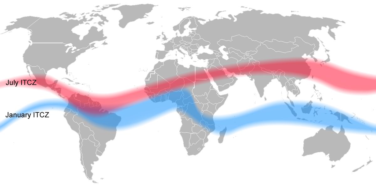
The intertropical convergence zone (ITCZ) is the broad zone where the north-east and south-east trade winds converge near the heat equator. It is also called the thermal equator, the heat equator or the equatorial trough. Its width varies from about 25 to 300 NM.
The ITCZ follows the sun. The Earth's axis is tilted about 23½° to the plane of its orbit, so the overhead sun moves from the Tropic of Cancer around 21 June to the Tropic of Capricorn around 21 December. The ITCZ follows with a lag of a few weeks and swings furthest into the summer hemisphere over large land masses, much less over the oceans. Over West Africa it lies south of the coasts of Ghana and Nigeria in January and reaches about 18° to 20° N in July; on the route from Cairo to Johannesburg it reaches its southern extreme, over Zimbabwe, in January. Near the equator itself, rainfall peaks around the equinoxes, when the zone passes overhead.
Unlike the polar front, the ITCZ is not a boundary between air masses of different temperature: the converging trades are usually of similar temperature, and the cloud comes from convergence and strong heating. Its main feature is extensive cumulus, cumulonimbus and thunderstorms; where the air is stable, sheets of altostratus and nimbostratus give more continuous rain instead.
The flying hazards are those of thunderstorms, on a large scale:
- Cloud tops are sometimes as low as 20,000 ft but more often 50,000 ft or more, above the cruising levels of most jets.
- Turbulence in the cells is usually severe.
- Icing can be severe from about 16,000 ft upwards; the freezing level near the equator is about 16,000 ft.
- High-altitude ice crystal icing near deep convection can block probes and cause engine power loss without the usual signs of airframe icing. The loss of Air France 447 in 2009 began with ice crystals blocking the pitot probes of an A330 crossing the ITCZ (see airframe icing).
Crews cross the zone with the weather radar in constant use, deviate around cells, often by 20 NM or more, and plan extra fuel for the deviations. Over West Africa the passage of the ITCZ brings West African squall lines, locally called "tornadoes": north-south lines of thunderstorms moving from east to west, most common from March to May and in October and November.
Exam tip: The ITCZ moves a long way over land and little over the sea, and lags the sun by a few weeks. Its cloud is caused by convergence of the trades, not by a temperature contrast between air masses.
Monsoons
A monsoon is a seasonal reversal of the prevailing wind driven by the temperature contrast between land and sea. In winter the land cools far below the sea, and air flows from land to sea; in summer the land heats up, a large thermal low forms over it and moist air flows in from the ocean. That summer low is the monsoon low, such as the Baluchistan Low over Pakistan.
Asia shows the effect on the grandest scale:
- The north-east monsoon, or winter monsoon, blows out of the winter Siberian High towards the ITCZ. Over land it is cool and comparatively dry, giving clear weather over Bangladesh, Burma and Thailand. Where it crosses the sea it picks up moisture, and on reaching south-east India, Sri Lanka and the east coast of West Malaysia it brings heap cloud, thunderstorms and heavy rain, especially over coastal mountains.
- The south-west monsoon, or summer monsoon, is the south-east trade wind of the southern hemisphere crossing the equator. As it crosses, the Coriolis deflection reverses and the wind veers to south-west, flowing towards the Baluchistan Low. After a long sea track it is very moist, and it brings heavy cumulus and cumulonimbus, large thunderstorms and the monsoon rains to India, Sri Lanka, Burma and the exposed coasts of West Malaysia.
The same pattern affects West Africa. In winter the dry, dusty Harmattan blows from the north-east between November and April, often cutting visibility to about 4,000 m and sometimes below 1,000 m, with dust reaching 7,000 to 10,000 ft. In summer, as the ITCZ moves north, a moist south-west monsoon replaces it. In the Straits of Malacca the south-west monsoon season also brings the Sumatras, squall lines that cross the straits at night and early morning. High above the summer monsoon, the tropical easterly jet blows from the South China Sea across southern India towards Africa.

Climatic zones
The circulation divides the Earth into four basic climatic zones, from the equator to the poles:
| Zone | Controlling feature | Typical weather |
|---|---|---|
| Warm, wet equatorial | Rising air at the ITCZ | Heavy convective rain in most months, thunderstorms |
| Warm, arid subtropical | Subsidence in the subtropical highs | Deserts, clear skies, dust and haze |
| Cool, wet temperate | Polar front depressions in the westerlies | Changeable; frontal cloud and rain in all seasons |
| Cold, dry polar | Subsidence in the polar high | Very cold, little precipitation |
Between them lie transitional climates that change with the seasons as the belts follow the sun. On the edges of the tropics, the passage of the ITCZ brings a rainy season and its retreat a dry one, as in West Africa. On the poleward edge of the subtropical highs, the Mediterranean has wet, stormy winters, when depressions run along the Mediterranean front, and dry summers, when the front disappears under the subtropical high.
The zones also shape the atmosphere above them. The tropopause lies at about 16 to 18 km over the equator and about 8 km over the poles, so tropical cumulonimbus build far higher than mid-latitude ones, and the freezing level rises from about 6,000 ft over the Mediterranean in winter to about 16,000 ft near the equator (see the atmosphere).
Frequently asked questions
What is the three-cell model of atmospheric circulation?
It divides the circulation of each hemisphere into three cells. In the Hadley cell air rises near the equator, flows poleward aloft and sinks at about 30 degrees, returning as the trade winds. In the polar cell cold air sinks over the pole and flows towards the polar front. Between them the Ferrel cell carries the surface westerlies of the middle latitudes. William Ferrel refined George Hadley's original single-cell model into this form.
What is the ITCZ and why does it matter to pilots?
The intertropical convergence zone is the broad belt, 25 to 300 NM wide, where the north-east and south-east trade winds converge near the heat equator. The converging air rises in cumulus, cumulonimbus and thunderstorms whose tops often reach 50,000 ft or more, with severe turbulence and icing. Long-haul crews cross it with weather radar, plan extra fuel for deviations and watch for high-altitude ice crystal icing.
What causes the monsoon?
A monsoon is a seasonal reversal of the prevailing wind caused by the temperature difference between a continent and the ocean. In winter the land is colder than the sea and air flows from land to sea; in summer the land heats, a large thermal low forms over it and moist air flows in from the ocean. In Asia this gives the cool, comparatively dry north-east monsoon in winter and the wet south-west monsoon in summer.
What are the trade winds?
The trade winds are the surface winds that blow from the subtropical high-pressure belts towards the equatorial trough. The Earth's rotation deflects them, so they blow from the north-east in the northern hemisphere and from the south-east in the southern hemisphere. They converge at the ITCZ, form the surface branch of the Hadley cell, and carry tropical revolving storms westward in their early life.
Why are there high-pressure belts at about 30 degrees latitude?
Air rising at the equator flows poleward near the tropopause, but the Earth's rotation turns it into a westerly flow, so it cannot continue to the pole. Near the subtropics the upper branches of the Hadley and Ferrel cells converge, and the surplus air sinks. The subsidence builds the warm subtropical anticyclones, such as the Azores High, and the dry, warm climate of the world's great deserts.
Test yourself on Global Circulation and Climate
The v1prep banks cover this topic in Meteorology (050), with a worked explanation for every answer. EASA ATPL, PPL, IR and CPL, the FAA written tests and A320/B737 type ratings.
Start practising →Sources and further reading
- FAA-H-8083-28B, Aviation Weather Handbook (Chapter 9, Global Circulations and Jet Streams)
- NOAA JetStream, Global Atmospheric Circulations
- Encyclopaedia Britannica, Hadley cell
- Encyclopaedia Britannica, Intertropical convergence zone
- India Meteorological Department, Frequently Asked Questions on Monsoon
- Meteorological Service Singapore, Weather Systems (monsoons and Sumatra squalls)
Library articles are written for study and exam preparation. They do not replace your aircraft's approved documentation, your operator's procedures or the regulations themselves.