Tropical Revolving Storms
A tropical revolving storm (TRS) is an intense non-frontal low that forms over a warm tropical ocean, with violent winds and cumulonimbus circling a calm central eye. Called a hurricane, typhoon or cyclone depending on the region, it reaches that status when its sustained wind exceeds 63 kt.
A tropical revolving storm (TRS) is the most violent weather system that grows over the oceans: a deep, non-frontal low in which bands of cumulonimbus spiral inwards to a ring of violent winds around a calm central eye. Depending on the ocean it is called a hurricane, a typhoon or a cyclone. Meteorologists use tropical cyclone as the general term; EASA ATPL texts use tropical revolving storm, and reserve tropical cyclone, in one of their usages, for the fully developed stage.
Airline crews do not fly through one. Their problem is at the edges: routes that must be moved, destinations and alternates closed by wind and rain, and aircraft that must leave threatened airports in time. Knowing how these storms form, move and are forecast lets a crew read the advisories and plan around them.
What a tropical revolving storm is
A TRS develops through recognised stages, classed by the sustained surface wind:
| Stage | Definition used in ATPL texts |
|---|---|
| Tropical depression | Organised circulation with at least one closed isobar; sustained wind up to 33 kt |
| Tropical storm | Sustained wind above 33 kt; the storm is given a name at this stage |
| Hurricane, typhoon or cyclone | Sustained wind above 63 kt, with pronounced rotation round a developing eye |
The threshold of the final stage is hurricane force: a sustained wind above 63 kt, that is 64 kt or more. The term describes the wind, not the storm, so a deep mid-latitude depression can also produce hurricane-force winds. For comparison, a gale is a mean wind above 33 kt or gusts above 42 kt.
Tropical revolving storms produce the lowest sea-level pressures on Earth. The record, 870 hPa, was measured in the eye of Typhoon Tip in the western Pacific in 1979; the lowest in the North Atlantic was 882 hPa, in Hurricane Wilma in 2005.
Conditions for formation
A TRS is a heat engine fuelled by the ocean. Warm, moist air converging at the surface rises in cumulonimbus, and the latent heat released as its water vapour condenses warms the core of the storm, lowering the surface pressure and drawing in more air. ATPL texts list the conditions it needs:
- A warm sea: a sea surface temperature above about 26 °C, with enough depth of warm water, quoted as 200 to 300 ft, to supply energy continuously.
- Latitude between about 5° and 25°: within about 5° of the equator the Coriolis effect is too weak to start the rotation, and beyond about 25° the sea is usually too cool.
- Little vertical wind shear: strong shear tilts and tears apart the column of convection before it can organise.
- A starting disturbance: storms generally develop from existing areas of convection, many of them adjacent to the ITCZ.
The sea temperature explains a well-known exception: tropical revolving storms do not usually form in the South Atlantic, where the sea is too cool (see global circulation and climate). It also explains how a storm dies. Once it moves over land or over colder water it loses its energy supply and weakens, although some survive as deep mid-latitude depressions.
Exam tip: Formation needs sea above 26 °C, latitude 5° to 25°, and little vertical wind shear. No TRS forms on the equator, where there is no Coriolis effect to start the spin.
Structure: eye, eye wall and rain bands
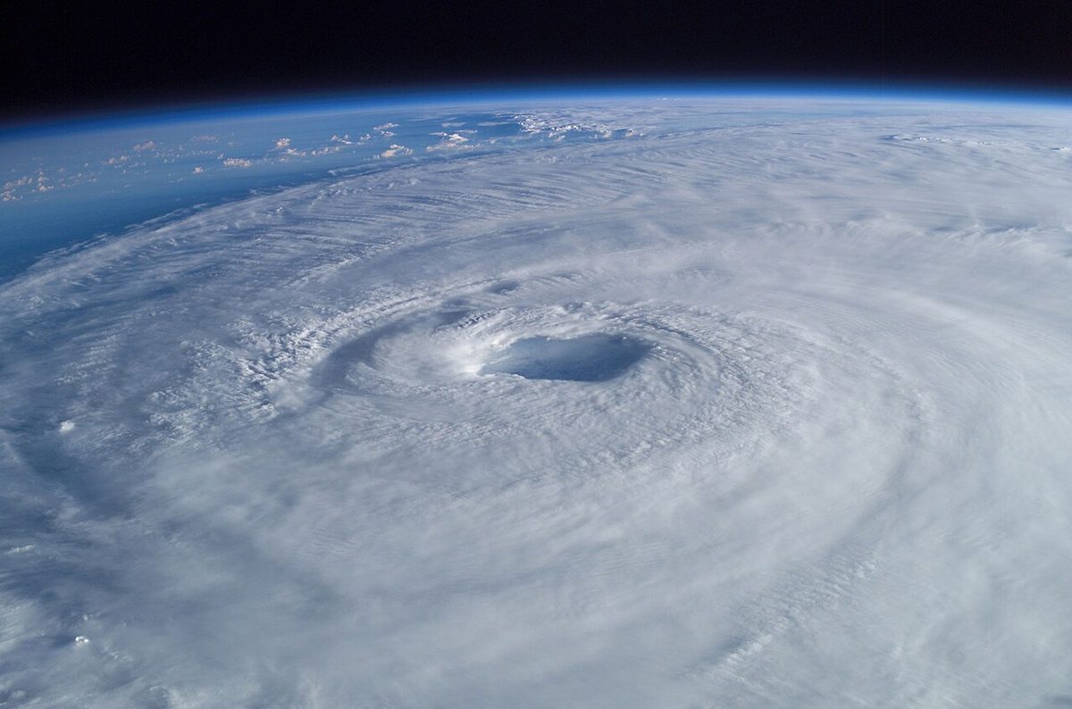
The eye is the calm centre, typically 20 to 50 km across, where the surface pressure is lowest. Air sinks in the eye. It cooled at the saturated adiabatic lapse rate as it rose in the surrounding cloud, but it descends dry, warming at the dry adiabatic rate, so the eye is warmer than the eye wall and often clear or only partly cloudy. A shrinking eye indicates that the storm is intensifying.
The eye wall is the ring of cumulonimbus surrounding the eye. It holds the most active cells, the strongest winds and the most severe turbulence, and is the most dangerous part of the storm.
Outside the eye wall, rain bands of cumulonimbus spiral in towards the centre, separated by areas of lighter rain. The whole system is capped by high cloud spreading outward, so cirrus and cirrostratus, sometimes with a halo, are often the first visible sign of an approaching storm in the tropics, much as they herald a warm front in the middle latitudes.
Regional names, seasons and wind strength
| Region | Local name |
|---|---|
| North Atlantic and eastern North Pacific | Hurricane |
| Western North Pacific | Typhoon |
| Indian Ocean, Australian region and South Pacific | Cyclone, or tropical cyclone |
The storms follow the warm water, so each basin has its season in the summer and autumn of its own hemisphere, when the sea is warmest and the ITCZ lies furthest from the equator. On the Singapore to Sydney route, for example, tropical cyclones form in January, the southern summer, over the Coral and Timor Seas. Warning centres name storms once they reach tropical storm strength, and grade their intensity by the sustained wind; the scales used differ between regions, so the thresholds in a local advisory should be read from that advisory.
Movement and the cone of uncertainty
In their early life most tropical revolving storms are carried westward by the easterly trade winds at about 10 to 20 kt. They then drift away from the equator, strengthening as the Coriolis effect increases, and recurve around the western edge of the subtropical high into the westerlies of higher latitudes, which carry them eastward until colder sea or land ends them. Tracks vary. Coral Sea cyclones, moving at 10 to 15 kt, may head west along the north Australian coast or curve round the South Pacific High to reach the east coast near Brisbane; some continue south-east across the Tasman Sea as deep depressions that bring strong winds to New Zealand's North Island.
A forecast track is shown as a cone of uncertainty: the forecast positions of the centre, surrounded by a cone that widens with time because position errors grow the further ahead the forecast runs. The cone describes where the centre may go, not the size of the storm. Winds are given separately as wind radii, so damaging winds can extend well outside the cone.
Advisories and warning centres
Tropical cyclones are tracked by six Regional Specialised Meteorological Centres (RSMCs), supported by Tropical Cyclone Warning Centres (TCWCs), such as those in Australia, each responsible for its own area.
The general tropical cyclone advisory issued by these centres typically gives:
- the present position of the centre and its direction and speed of movement;
- the central pressure and the diameter of the eye;
- the maximum sustained wind and gusts;
- the radii of 64, 50 and 34 kt winds in each quadrant, north-east, south-east, south-west and north-west;
- forecast positions and intensities, typically for the next three to five days, shown as the cone.
Aviation has its own, shorter product. Under ICAO Annex 3, a tropical cyclone advisory centre sends the meteorological watch offices an advisory in abbreviated plain language: the position of the centre, its direction and speed of movement, the central pressure and the maximum surface wind near the centre, with forecast positions for the hours ahead rather than for several days. Neither advisory is a message to the aircraft. The meteorological watch office of each affected flight information region uses them to issue a tropical cyclone SIGMET, identified by the letters WC. While most SIGMETs are valid for up to 4 hours, tropical cyclone and volcanic ash SIGMETs may be valid for up to 6 hours, because these phenomena evolve more slowly. The same 6-hour validity applies to US tropical cyclone SIGMETs (see SIGMET, AIRMET and weather warnings).
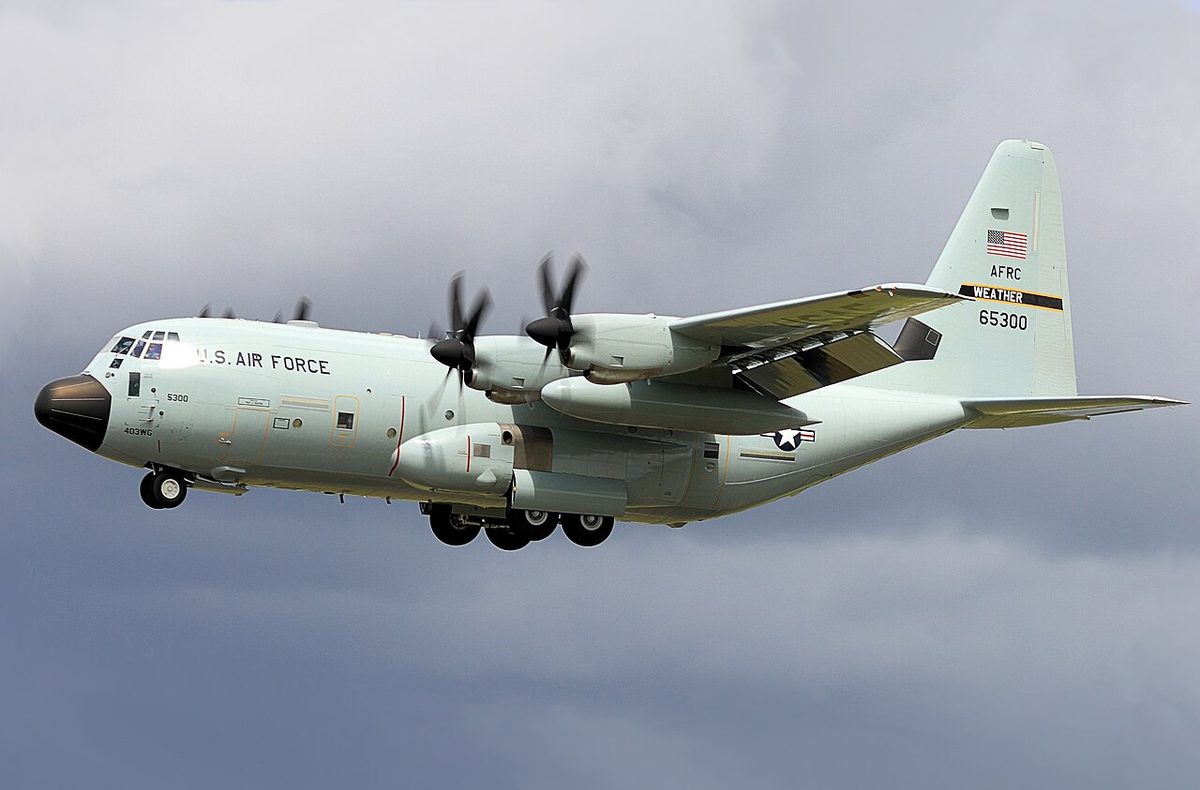
In the United States, the Hurricane Hunters of the US Air Force Reserve's 53rd Weather Reconnaissance Squadron and NOAA's Aircraft Operations Center fly into hurricanes to measure them. Their missions are flown in a weather reconnaissance area (WRA), published by NOTAM within US flight information regions outside US territorial airspace. No ATC service is provided inside a WRA, only participating aircraft may operate there, and IFR traffic should expect to be rerouted around it.
Operational hazards
For a crew en route, the hazards are those of thunderstorms multiplied: severe turbulence and windshear in the eye wall and rain bands, torrential rain, lightning and poor visibility, and icing in the cumulonimbus above the freezing level, which in the tropics lies at about 16,000 ft. Weather radar shows the rain bands, but the only sound plan is to route well clear of the storm, using the advisories and SIGMETs at the planning stage (see weather radar).
Near a storm without guidance, the circulation itself gives a warning. By Buys Ballot's law, in the northern hemisphere a wind from the left, and therefore a drift to starboard, means the centre lies ahead. ATPL texts give the rule: if the starboard drift becomes very large, turn until port drift is obtained, and the aircraft is then heading away from the storm. In the southern hemisphere the drifts are reversed.
Warning: Hurricane-force winds and heavy rain close aerodromes for many hours. Check the storm's forecast track against the destination, the alternates and the return fuel, and remember that the eye wall, with the strongest winds, arrives before the centre does.
On the ground, a TRS forecast to cross an airport leads to closure, and operators plan to move aircraft away or secure them before the winds exceed their limits. Crosswinds, gusts and windshear can exceed aircraft limits long before the centre arrives, and flooding can leave runways and facilities unusable after it has passed. When the eye passes overhead, the calm is temporary: the wind returns, from the opposite direction, as the far side of the eye wall arrives.
Frequently asked questions
What is the difference between a hurricane, a typhoon and a cyclone?
They are the same weather system, a tropical revolving storm with sustained winds above 63 kt, named differently by region. It is a hurricane in the North Atlantic and the eastern North Pacific, a typhoon in the western North Pacific, and a cyclone or tropical cyclone in the Indian Ocean, around Australia and in the South Pacific. Meteorologists use tropical cyclone as the general term for all of them.
What conditions are needed for a tropical revolving storm to form?
ATPL texts list a sea surface temperature above about 26 degrees Celsius, with a sufficient depth of warm water, quoted as 200 to 300 ft, to keep supplying energy; a latitude between about 5 and 25 degrees, because the Coriolis effect is too weak nearer the equator; and very little vertical wind shear, so that the storm is not torn apart. Storms usually start from a disturbance near the ITCZ.
What is the eye of a hurricane?
The eye is the calm centre of a tropical revolving storm, typically 20 to 50 km across, where the surface pressure is lowest. Air sinks in the eye and warms as it descends, so it is warmer and drier than its surroundings and often nearly cloud-free. Around it the eye wall holds the most active cumulonimbus, the strongest winds and the most severe turbulence. A shrinking eye indicates a strengthening storm.
What is the cone of uncertainty in a hurricane forecast?
The cone shows the forecast track of the storm's centre widening with time, because the error in forecast positions grows the further ahead the forecast runs. It describes where the centre may go, not how big the storm is. Damaging winds, given separately as wind radii for 34, 50 and 64 kt, can extend well outside the cone, so being outside it does not mean being safe.
How long is a tropical cyclone SIGMET valid?
A SIGMET for a tropical cyclone may be valid for up to 6 hours, longer than the usual maximum of 4 hours, because the storm evolves more slowly than most SIGMET phenomena. The same applies to volcanic ash. The meteorological watch office issues it using the advisories of the regional tropical cyclone centre. In the United States, tropical cyclone SIGMETs are also valid for 6 hours.
Test yourself on Tropical Revolving Storms
The v1prep banks cover this topic in Meteorology (050), with a worked explanation for every answer. EASA ATPL, PPL, IR and CPL, the FAA written tests and A320/B737 type ratings.
Start practising →Sources and further reading
- FAA-H-8083-28B, Aviation Weather Handbook (Chapter 17, Tropical Weather)
- US National Hurricane Center, How to use the cone graphic
- ICAO EUR Doc 014, EUR SIGMET and AIRMET Guide
- FAA Aeronautical Information Manual, Chapter 7, Section 1 (Meteorology, SIGMETs)
- FAA Aeronautical Information Manual, Chapter 3, Section 5 (3-5-9, Weather Reconnaissance Area)
- Encyclopaedia Britannica, Tropical cyclone
Library articles are written for study and exam preparation. They do not replace your aircraft's approved documentation, your operator's procedures or the regulations themselves.