Humidity and Water Vapour
Humidity is the amount of water vapour in the air, expressed as absolute humidity, a mixing ratio, a relative humidity or a dew point. As water changes between vapour, liquid and ice it absorbs or releases latent heat, and these changes drive cloud, fog, precipitation and airframe icing.
Humidity is the water vapour content of the air. Water vapour is an invisible gas, and although it makes up only a small and variable part of the atmosphere, meteorology texts rank it as the most important gas of all from a weather point of view: without it there would be no cloud, fog, precipitation or airframe icing. The amount of vapour air can hold depends on its temperature, so meteorologists use several measures of humidity, each suited to a different job.
For pilots, humidity matters in three ways. It decides how close the air is to forming cloud or fog, which is read from the temperature and dew point in every METAR. Its changes of state absorb and release latent heat, which powers thunderstorms, sets the rate at which rising cloud cools and shapes the ice that forms on an airframe. And it lowers air density, which degrades performance on hot, humid days.
Water vapour in the atmosphere
Water vapour enters the air by evaporation from oceans, lakes and wet ground, by transpiration from plants and by sublimation from snow and ice. It leaves by condensation into droplets, by deposition as ice crystals and, in the end, as precipitation. Its share ranges from almost nothing in polar or desert air to a few per cent by volume in warm, moist air, and because warm air holds far more vapour than cold air, most of it lies in the lower troposphere.
Cloud, fog and mist are not vapour but liquid droplets or ice crystals suspended in the air; the vapour itself cannot be seen.
Water vapour is lighter than dry air, with a density of about five-eighths that of dry air at the same temperature and pressure. Humid air is therefore less dense, which raises the density altitude. Performance charts assume dry air, so on a hot, humid day an aeroplane accelerates and climbs a little worse than the chart predicts, and a piston engine also loses some power because the vapour displaces oxygen. Water vapour also absorbs the long-wave radiation emitted by the earth, which slows cooling on humid nights.
Absolute and relative humidity
Absolute humidity is the mass of water vapour in a unit volume of air, usually in grams per cubic metre (g/m³). It is awkward to use, because a rising parcel expands and its absolute humidity falls although no water has been removed.
Relative humidity (RH) compares the vapour actually present with the most the air could hold at its current temperature, as a percentage. It describes closeness to saturation, not the amount of water: saturated air in a polar winter holds far less vapour than hot desert air at a low relative humidity. Because the capacity of the air changes with temperature, RH changes whenever the temperature does, even when no moisture is added or removed:
- Over a day, with no change of air mass, RH falls as the temperature rises and rises as it falls. It peaks around dawn, when the temperature is lowest, and is lowest in the afternoon.
- Air moving over a warmer surface is heated and its RH falls; air moving over a colder surface is cooled and its RH rises.
- Air sinking in an anticyclone warms adiabatically and its RH falls, which is why subsidence disperses cloud.
In a pressurised cabin the effect is extreme. Outside air at cruise level holds very little vapour; compressed and heated to cabin temperature, it gives a cabin relative humidity that typically falls to between 5 and 15 % on long flights.
Mixing ratios and saturation
The humidity mixing ratio (HMR) is the mass of water vapour per unit mass of dry air, in grams per kilogram (g/kg). As long as there is no condensation or evaporation, the HMR of a parcel stays constant however far it rises or sinks, which makes it the natural measure for tracking air on an upper-air diagram.
The saturation mixing ratio (SMR) is the largest HMR the air could hold at its temperature and pressure. It rises steeply with temperature, and relative humidity is simply the ratio of the two:
RH = (HMR ÷ SMR) × 100 %
Each gas in the air exerts its own share of the total pressure, and the share exerted by water vapour is the vapour pressure. Saturation is the state in which the air holds all the vapour it can at its temperature: the RH is 100 % and the vapour pressure equals the saturation vapour pressure, which depends only on temperature and increases rapidly as temperature rises. By definition only air at 100 % RH is saturated; air at 95 % counts as unsaturated, or "dry" in the language of exam texts.
Below 0 °C the saturation vapour pressure over ice is lower than over supercooled water. Air just saturated with respect to water is therefore supersaturated with respect to ice, and in a cloud containing both, the ice crystals grow at the expense of the droplets. This Bergeron, or Wegener-Bergeron-Findeisen, process is the main source of precipitation from cold cloud (see precipitation).
Air reaches saturation in two ways: it is cooled until its SMR falls to its actual HMR, or moisture is added until its HMR rises to the SMR. Cooling by ascent forms most cloud. Cooling by contact with a cold surface forms radiation and advection fog, while evaporation from rain or from a warmer sea adds the moisture behind frontal fog and steaming fog (see fog).
Dew point and frost point
The dew point is the temperature to which air must be cooled, at constant pressure and without any change in its moisture content, to become saturated. It measures how much vapour the air holds: the higher the dew point, the moister the air. Cooling below it causes condensation, as dew on surfaces or as fog and cloud in the air itself.
Below 0 °C saturation can also be reckoned with respect to ice. The frost point is the temperature at which the air becomes saturated with respect to ice. Because the saturation vapour pressure over ice is the lower of the two, the frost point lies slightly above the dew point. When a surface cools below the frost point, vapour is deposited on it directly as ice, forming hoar frost.

On a clear, calm night a parked aeroplane's skin radiates heat to the sky and cools below the surrounding air. If the dew point is above freezing, dew forms; if it is below freezing, frost forms, even when the reported air temperature is a few degrees above zero. Hoar frost also forms in flight when a cold-soaked aeroplane descends quickly into warm, moist air, where it can obscure the windscreen. On the ground it must be removed completely before take-off: it barely changes the shape of the wing, but its roughness cuts maximum lift and raises the stall speed out of all proportion to its thickness (see airframe icing).
Temperature and dew point appear in every METAR in whole degrees Celsius, with M for minus: 10/M02 is +10 °C with a dew point of −2 °C. US reports often add a remarks group, the T group, giving both to a tenth of a degree (see METAR and SPECI).
Temperature-dew point spread
The temperature-dew point spread, or dew point depression, is the difference between the air temperature and the dew point. It is the pilot's quickest measure of how near the air is to saturation.
- Fog. A spread that keeps closing on a clear evening with a light wind is the classic warning of radiation fog. An ATIS giving +12 °C and a dew point of +11 °C at dusk, with clear skies and a light wind, means one more degree of cooling will saturate the air. The FAA treats a spread of about 2 to 3 °C (4 °F) or less, still closing, as a sign that fog or low cloud is likely.
- Convective cloud base. In rising unsaturated air the temperature falls by about 3 °C per 1,000 ft, while the dew point falls by only about 0.5 °C per 1,000 ft. The spread closes at about 2.5 °C per 1,000 ft, so the base of cumulus lies roughly 400 ft above the surface for each degree of spread: +22 °C and +13 °C give a base near 3,600 ft. For Fahrenheit readings the FAA divides the spread by 4.4 °F per 1,000 ft. The method is set out in atmospheric stability.
- Carburettor icing. A small spread means high humidity, and moist air at the right temperature makes carburettor icing likely even in clear air.
Exam tip: Dew point measures the moisture content; relative humidity measures closeness to saturation. When the temperature falls overnight and the dew point stays the same, the moisture content is unchanged but the relative humidity rises.
Changes of state and latent heat
Water in the atmosphere exists as vapour, liquid and ice, and moves between them by six changes of state. Each absorbs or releases latent heat: heat taken in or given out while a substance changes state, without any change in its temperature.
| Change | From and to | Latent heat |
|---|---|---|
| Evaporation | Liquid to vapour | Absorbed |
| Condensation | Vapour to liquid | Released |
| Melting | Ice to liquid | Absorbed |
| Freezing | Liquid to ice | Released |
| Sublimation | Ice to vapour | Absorbed |
| Deposition | Vapour to ice | Released |
EASA texts often use sublimation for both directions of the change between vapour and ice, and older FAA texts do the same; newer FAA material calls the vapour-to-ice change deposition. The heat exchanged between liquid and vapour is the latent heat of vaporisation; the heat exchanged between ice and liquid is the latent heat of fusion; a direct change between ice and vapour exchanges the sum of the two.
Latent heat explains much of aviation weather:
- Saturated air cools more slowly than dry air. Condensation in a rising saturated parcel gives latent heat back to it, so the saturated adiabatic lapse rate is smaller than the dry rate. That is the root of conditional instability and of the energy of cumulonimbus.
- The föhn effect. Air that loses moisture as rain on the windward side of a range, then descends at the dry rate, arrives in the lee warmer and drier.
- Clear ice. When a large supercooled droplet strikes an airframe, the latent heat of fusion released by the part that freezes keeps the rest liquid long enough to flow back. EASA texts give a rule of thumb that about 1/80 of the droplet freezes on impact for each degree below 0 °C.
- Evaporative cooling. Precipitation evaporating below a cloud base, visible as virga, chills the air, makes it denser and accelerates the downdraught, a warning of possible microbursts. Fuel evaporating in a carburettor cools the induction air in the same way.
Condensation and freezing nuclei
Vapour does not readily condense on itself. Cloud droplets form on condensation nuclei: microscopic particles of salt, dust, smoke and other aerosols, which are plentiful in the lower atmosphere. Hygroscopic nuclei such as sea salt attract water and start droplets growing slightly before full saturation, one reason mist can form with relative humidity just below 100 %; ATPL texts associate mist with relative humidity above 95 %.
Freezing is different. A droplet cooled below 0 °C needs a freezing nucleus to start freezing, and freezing nuclei are far less common than condensation nuclei. Cloud droplets therefore stay liquid below 0 °C as supercooled water droplets, common down to about −20 °C, while small droplets survive to about −40 °C, below which they freeze spontaneously. Supercooled droplets freeze on contact with an airframe and cause most in-flight structural icing. Hoar frost likewise needs an ice nucleus, or sublimation nucleus, on which the vapour can deposit.
Measuring humidity: hygrometers and the wet bulb
A hygrometer is any instrument that measures humidity. The classic type is the wet- and dry-bulb hygrometer, or psychrometer: two thermometers side by side in a Stevenson screen, a louvred white box whose thermometers sit about 1.2 m (4 ft) above the ground. The dry bulb reads the air temperature. The wet bulb has its bulb wrapped in muslin kept wet with distilled water.
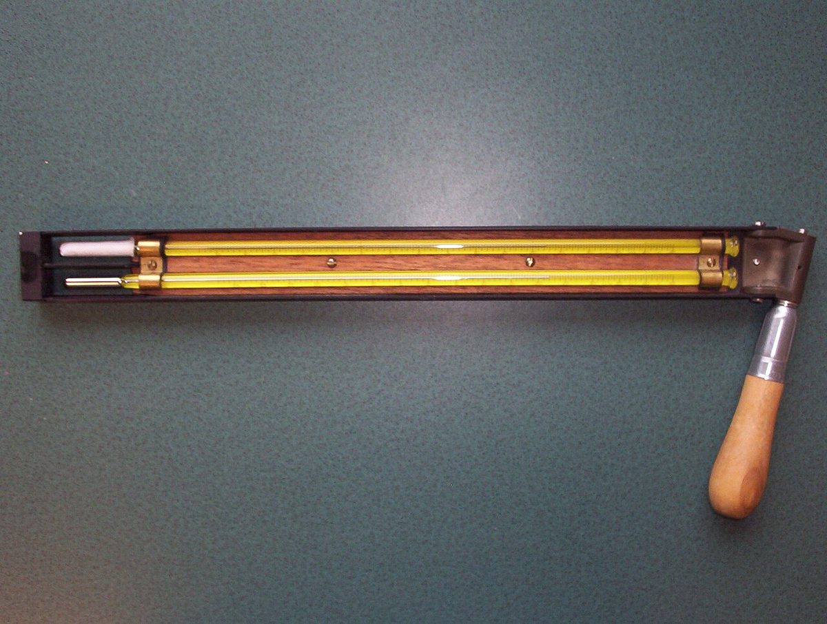
Water evaporating from the muslin absorbs latent heat and cools the bulb, which settles at the wet-bulb temperature. The drier the air, the faster the evaporation and the larger the difference between the two readings. In saturated air there is no net evaporation, so the two thermometers agree, and both then equal the dew point. In unsaturated air the wet-bulb temperature lies between the dew point and the air temperature, so it is not the dew point. Hygrometric tables convert the two readings into dew point and relative humidity.
Automatic stations use electronic humidity sensors, and radiosondes measure humidity aloft, giving the dew point curve plotted on an upper-air diagram.
Frequently asked questions
What is the difference between dew point and relative humidity?
The dew point is the temperature to which air must be cooled, at constant pressure, to become saturated, so it measures how much water vapour the air actually holds. Relative humidity is the vapour present as a percentage of the most the air could hold at its current temperature. When air cools at night with no change of moisture, the dew point stays the same but the relative humidity rises.
Why does high humidity reduce aircraft performance?
Water vapour has a density of only about five-eighths that of dry air, so moist air is less dense than dry air at the same pressure and temperature. Lower density means a higher density altitude, longer take-off runs and poorer climb. The vapour also displaces oxygen, costing piston engines some power. Performance charts assume dry air, so on a hot, humid day real performance is slightly worse than charted.
What is latent heat in meteorology?
Latent heat is the heat absorbed or released when water changes state, without any change in its temperature. Evaporation, melting and sublimation absorb it; condensation, freezing and deposition release it. Heat released by condensation makes rising saturated air cool more slowly than dry air, which powers cumulonimbus and thunderstorms, while heat absorbed by evaporation cools the air below a cloud and the wet bulb of a hygrometer.
Why does a wet-bulb thermometer read lower than a dry-bulb thermometer?
The wet bulb is wrapped in muslin soaked in distilled water. Water evaporates from the muslin and absorbs latent heat from the bulb, cooling it. The drier the air, the faster the evaporation and the larger the difference between the two readings. In saturated air there is no net evaporation, so both thermometers read the same, and that temperature is also the dew point.
How can frost form on an aircraft when the air temperature is above freezing?
On a clear, calm night an aircraft's skin radiates heat to the sky and becomes colder than the air around it. If the skin cools below the frost point, water vapour is deposited on it directly as ice, even though the reported air temperature, measured about 1.2 m above the ground, may be a few degrees above zero. The frost must be removed completely before take-off.
Test yourself on Humidity and Water Vapour
The v1prep banks cover this topic in Meteorology (050), with a worked explanation for every answer. EASA ATPL, PPL, IR and CPL, the FAA written tests and A320/B737 type ratings.
Start practising →Sources and further reading
- FAA Pilot's Handbook of Aeronautical Knowledge (FAA-H-8083-25), Chapter 12, Weather Theory
- FAA-H-8083-28B, Aviation Weather Handbook
- EASA, Explanatory Note to ED Decision 2018/001/R, Part-FCL theoretical knowledge learning objectives
- FAA Advisory Circular AC 91-74B, Pilot Guide - Flight in Icing Conditions
- FAA Advisory Circular AC 20-117, Hazards Following Ground Deicing and Ground Operations in Conditions Conducive to Aircraft Icing
Library articles are written for study and exam preparation. They do not replace your aircraft's approved documentation, your operator's procedures or the regulations themselves.