SBAS and GBAS Augmentation
External augmentation systems make GNSS fit for approach and landing by measuring its errors at surveyed reference stations and broadcasting corrections and integrity data. A satellite-based augmentation system (SBAS) serves a continent through geostationary satellites; a ground-based augmentation system (GBAS) serves one airport through a VHF data link.
On its own, a GNSS receiver gives a position good enough for en-route and terminal navigation, but not one that can be trusted all the way down to a few hundred feet above a runway. Augmentation closes the gap. Reference receivers at surveyed positions measure the errors in the satellite signals, and corrections, together with warnings about any satellite that must not be used, are broadcast to the aircraft. A satellite-based augmentation system (SBAS) does this for a whole continent, relaying its messages through geostationary satellites. A ground-based augmentation system (GBAS) does it for one airport through a VHF radio link.
The two support different approaches. SBAS provides the LP and LPV lines of an RNP approach, LPV down to a 200 ft decision height where the runway allows it. GBAS provides the GBAS landing system (GLS), a precision approach flown like an ILS. ICAO standardises both in Annex 10. FAA material speaks of WAAS and GBAS, which it formerly called the Local Area Augmentation System (LAAS); European material speaks of EGNOS, SBAS CAT I and GLS.
Why GNSS needs augmentation
A navigation system for a given phase of flight is judged on accuracy, integrity (a timely warning when its output is wrong), continuity and availability. ICAO specifies the basic GPS service at 13 m horizontally and 22 m vertically (95%), and real performance is better (see GNSS). Two weaknesses remain. Vertical accuracy is poorer than horizontal, because every satellite in view lies above the horizon. And a satellite can broadcast faulty data for some time before the control segment notices.
Aircraft-based augmentation (ABAS), mainly receiver autonomous integrity monitoring (RAIM), checks the satellites against one another. It improves integrity but not accuracy, and the largest error for a single-frequency receiver, the ionospheric delay, stays in the position (see GNSS integrity and RAIM). External augmentation improves both: it corrects the errors and watches every satellite from the ground.
Differential GPS principle
Differential GPS (DGPS), differential GNSS in ICAO terms, rests on a simple idea. A reference receiver at a precisely surveyed position knows where it is, so it can compute the true range to each satellite and compare it with the pseudo-range it measures. The difference is the error in that satellite's signal at that moment. Most of it, the satellite clock and ephemeris errors and most of the ionospheric and tropospheric delay, is shared by any receiver nearby, so a correction broadcast by the station removes it from the user's measurement as well. Errors born at the user's own antenna, multipath and receiver noise, are not shared and cannot be corrected.
A correction is only as good as the similarity between the paths of the two signals, so it loses validity with distance from the reference station. The two systems deal with this differently. GBAS keeps the user close to its reference receivers, in the airport area. SBAS uses a continental network and, instead of a single correction per satellite, broadcasts satellite clock and orbit corrections and a model of the ionosphere that each receiver applies for its own position. Both also monitor integrity and tell the receiver when a satellite must not be used.
Satellite-based augmentation systems
The FAA's Wide Area Augmentation System (WAAS) shows the architecture:
- Wide-area reference stations (WRS), precisely surveyed, monitor the GPS signals.
- Wide-area master stations (WMS) compute satellite clock and ephemeris corrections and model the ionosphere.
- A geostationary earth orbit (GEO) satellite receives the correction message from a GEO uplink subsystem at a ground earth station and broadcasts it on the GPS L1 frequency, 1575.42 MHz.
WAAS uses 38 reference stations, three master stations, six ground earth stations and three GEO satellite links. Geostationary satellites orbit over the equator at about 35,800 km, so each covers a large part of the Earth, but they are seen low on the horizon from high latitudes. The FAA notes that most of North America has redundant coverage by two or more geostationary satellites, the northern slope of Alaska being an exception, and that locations near the edge of coverage may have lower availability of vertical guidance.
The GEO satellite also transmits a ranging signal of its own, in effect an extra GPS satellite in view, which improves availability. Integrity comes from real-time monitoring: the receiver is told which signals to exclude, and outside SBAS coverage it reverts to the fault detection and exclusion of a basic receiver. The integrity limits tighten markedly. For GPS, LNAV and LNAV/VNAV approach modes the lateral limit is 0.3 NM (556 m); for LPV it is 40 m. Vertical errors are bounded to 50 m for LNAV/VNAV and for LPV lines with minima of 250 ft or more, and to 35 m for LPV minima below 250 ft.
In the United States the equipment is certified to TSO-C145() or TSO-C146(). Ionospheric storms can still deny vertical guidance at times, hence the FAA's "WAAS MAY NOT BE AVBL" NOTAMs.
Regional SBAS services
| System | Region | Notes |
|---|---|---|
| Wide Area Augmentation System (WAAS) | North America | FAA system, operational since July 2003 |
| European Geostationary Navigation Overlay Service (EGNOS) | Europe | LPV-200 service since 29 September 2015 |
| MTSAT Satellite-based Augmentation System (MSAS) | Japan | Named after the Multi-functional Transport Satellites |
| GPS-Aided GEO Augmented Navigation (GAGAN) | India | Uses GSAT geostationary satellites |
All follow the ICAO standards for SBAS, and together they are meant to form one wide-area capability, although each State may place its own limitations on the use of its system. SBAS positions, like all GNSS positions, are referenced to WGS-84, and the FAA advises using them only where the published aeronautical data conform to WGS-84 or an equivalent.
LP, LPV and SBAS CAT I
Two lines of minima on an RNP approach, known in the United States as RNAV (GPS), require SBAS:
- LPV (localiser performance with vertical guidance) gives angular lateral and vertical guidance whose sensitivity increases towards the runway, close to that of an ILS. The FAA designs it with the same TERPS criteria as an ILS and allows decision altitudes as low as 200 ft above touchdown with visibility down to 1/2 statute mile, where terrain and airport infrastructure permit.
- LP (localiser performance) gives the same sharp angular lateral guidance without vertical guidance and ends at a minimum descent altitude. It is published only where terrain or obstacles prevent an LPV, and it is not a fall-back mode for LPV. Its narrower obstacle clearance surface can give lower minima than LNAV. Some older WAAS receivers approved before TSO-C145b and TSO-C146b cannot fly LP even if they fly LPV.
The final approach course is tailored so that its total width is usually 700 ft at the threshold, and its splay angle is fixed. Because the path is geometric, it is unaffected by temperature, an incorrect altimeter setting or the lack of a local altimeter source, the limitations of baro-VNAV.
In Europe, the EGNOS LPV-200 service lets LPV approaches go down to a 200 ft decision height, known as SBAS CAT I. AIP France classes LPV to 200 ft as a precision approach and other LPV lines as APV SBAS, with heights in both cases referred to the runway threshold. The FAA's AIM classes LPV as an approach with vertical guidance (APV), since it is not required to meet the Annex 10 precision approach standards. Commission Implementing Regulation (EU) 2018/1048 requires LPV minima at European instrument runway ends, subject to the exceptions the rule allows.
The SBAS final approach segment is defined by a data block published in the AIP and coded in the navigation database. Charts give it a channel number and a reference path identifier: the RNP RWY 03 at Nantes Atlantique reads "EGNOS Ch 65065 E03A", and the FAA's RNAV (GPS) Y RWY 14R at Boeing Field shows "CH 92568" and "W14A".
On activating an approach, a WAAS receiver annunciates the most accurate level of service that the signal, the receiver and the procedure together support, such as LPV, LNAV/VNAV or LNAV, and does not upgrade again until the next approach is activated. Nor does it fail down to a lower level during the approach. If only the vertical guidance is flagged, the pilot may use the LNAV minima where the operating rules allow a change of approach type after the procedure has begun; if the lateral integrity limit is exceeded on an LP approach, a missed approach is necessary.
Ground-based augmentation and pseudolites
A GBAS ground facility has at least four reference receivers near the runways, a corrections processor and a VHF data broadcast (VDB) antenna. The VDB, in the band from 108 to 117.975 MHz used by ILS localisers and VORs, transmits corrections, integrity parameters and the definition of each final approach path. Because the reference receivers are close to the aircraft, the corrections remove nearly all of the common errors. A single ground station can support several approaches to one or more runways. The GBAS approach service type designated GAST C supports CAT I operations, and GAST D is designed for CAT II and III.
A pseudolite, short for pseudo-satellite, is a ground transmitter at a surveyed position broadcasting a satellite-like ranging signal, which a receiver treats as one more satellite. Exam texts describe it as a possible GBAS element that gives an accurate range near the runway threshold. The FAA's description of a GBAS ground facility contains no pseudolite: reference receivers, a processor and the VDB.
| SBAS | GBAS | |
|---|---|---|
| Coverage | Continent | One airport area |
| Broadcast | Geostationary satellites, GPS L1 | VHF data broadcast, 108 to 117.975 MHz |
| Corrections | Satellite clock and orbit, ionospheric model | Corrections for the local area |
| Approach | LP, LPV (SBAS CAT I to 200 ft) | GLS: CAT I with GAST C, CAT II/III with GAST D |
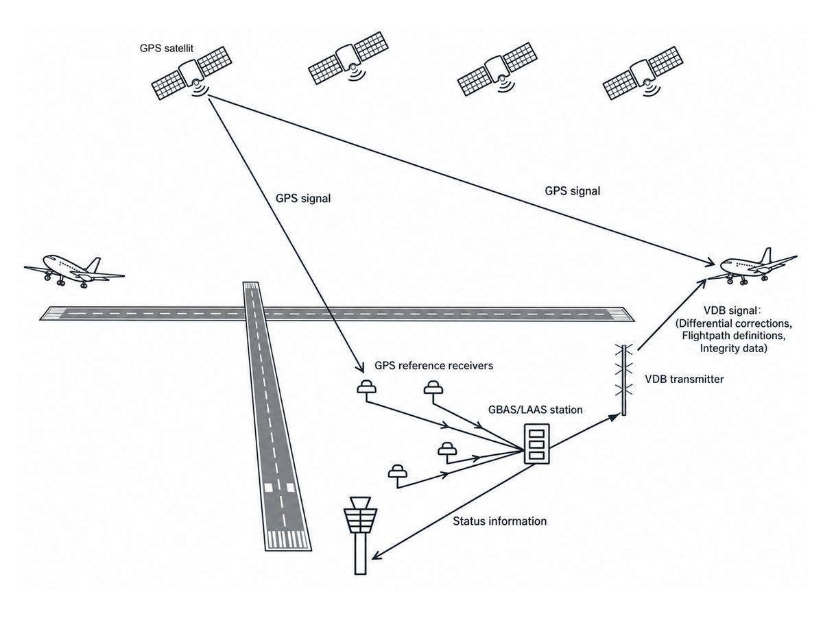
GBAS Landing System (GLS)
The GBAS landing system (GLS) is the aircraft side of GBAS. Charts title the procedure GLS RWY xx and give a four-character reference path identifier (RPI), used like the identifier of an ILS. On A320-family aircraft fitted with multi-mode receivers, the GLS receivers sit in the same units as the ILS receivers.
To fly a GLS, the aircraft must be eligible for RNP APCH and carry an approved GBAS receiver. The procedure before the final approach segment is designed to RNP APCH criteria, so it may include turns after the initial approach fix, and transitions may rely on RNAV 1 or RNP 1. The missed approach also uses RNP APCH criteria. When vectored, the crew intercepts the extended final approach course within the GLS service volume, confirms that the aircraft is in GLS approach mode before the glidepath intercept point, and then flies the final segment with the same techniques as an ILS or an LPV. The FAA does not allow circling from a GLS.
GLS is a precision approach. On the A320 the wind limits for a GLS CAT I autoland are the same as for a CAT II or III ILS autoland, 30 kt headwind, 10 kt tailwind and 20 kt crosswind, and with AUTO LAND on the flight mode annunciator the autopilot may stay engaged to touchdown.

SBAS Landing System (SLS)
SLS (SBAS landing system) is Airbus's name for the function that flies SBAS approaches with ILS-like guidance and modes. On the A320 it is certified for RNAV (GNSS) approaches with LPV or LP minima. When the approach mode is selected, the flight mode annunciator shows the approach capability, APPR1 for an SLS approach, and on an LPV approach with APPR1 displayed the minimum autopilot use height is 160 ft AGL. The standard technique is the decelerated approach, as for ILS, GLS and FLS approaches, so a crew flies an LPV with the same actions as an ILS. Embraer's E190 operating manual summary likewise gives the E2 a single autopilot minimum use height, 80 ft, for both ILS and LPV approaches.

The common thread is that the crew sees ILS-like deviations while the guidance comes from satellites. The integrity, however, depends on the satellites and on the augmentation system as well as on the aircraft, so SBAS NOTAMs, the annunciated level of service and the GBAS status are part of every briefing.
Frequently asked questions
What is the difference between SBAS and GBAS?
SBAS covers a continent. A network of reference stations computes satellite clock, orbit and ionospheric corrections and integrity data, which geostationary satellites broadcast on the GPS L1 frequency. It supports LP and LPV approaches at runways throughout its coverage, with no equipment at the airport. GBAS covers one airport. At least four reference receivers feed a processor, and a VHF data broadcast sends corrections, integrity data and the final approach path for GLS precision approaches.
Is an LPV approach a precision approach?
It depends on the minimum and the authority. The FAA classes LPV as an approach with vertical guidance (APV), because it is not required to meet the ICAO Annex 10 precision approach standards, even though its decision altitude can be as low as 200 ft. In Europe an LPV to a 200 ft decision height is called SBAS CAT I, and AIP France classes it as a precision approach, with other LPV lines as APV SBAS.
What is EGNOS?
EGNOS, the European Geostationary Navigation Overlay Service, is Europe's satellite-based augmentation system, the counterpart of the American WAAS. Ground stations monitor the GPS satellites and geostationary satellites broadcast corrections and integrity data to receivers across Europe. Its LPV-200 service, available since 29 September 2015, allows LPV approaches down to a 200 ft decision height, known as SBAS CAT I. Approach charts give the EGNOS channel number and path identifier.
What is a GLS approach?
GLS, the GBAS landing system, is a precision approach using GPS corrected by a ground-based augmentation system at the airport. The ground station broadcasts corrections, integrity data and the definition of the final approach path by VHF data link, and the aircraft displays angular lateral and vertical deviations like an ILS. Charts title it GLS RWY xx and give a four-character approach identifier. One ground station can serve several runway ends.
What is a pseudolite?
A pseudolite, short for pseudo-satellite, is a ground-based transmitter at a surveyed position that broadcasts a satellite-like ranging signal, so a receiver can treat it as one more satellite. Exam texts describe it as a possible GBAS element giving an accurate range near the runway threshold. Pseudolites are not part of the GBAS ground facility the FAA describes, which consists of reference receivers, a processor and a VHF data broadcast.
Test yourself on SBAS and GBAS Augmentation
The v1prep banks cover this topic in General and Radio Navigation (061/062), with a worked explanation for every answer. EASA ATPL, PPL, IR and CPL, the FAA written tests and A320/B737 type ratings.
Start practising →Sources and further reading
- FAA Aeronautical Information Manual, Chapter 1 Section 1 (1-1-18 WAAS, 1-1-19 GBAS Landing System)
- FAA Aeronautical Information Manual, Chapter 5 Section 4 (RNAV minima lines, GLS charting, circling restrictions)
- ICAO Annex 10, Aeronautical Telecommunications, Volume I, Radio Navigation Aids (GNSS, SBAS and GBAS standards; copy published by IACM Mozambique)
- European GNSS Service Centre, First EGNOS LPV-200 approach implemented at Charles de Gaulle Airport
- AIP France, ENR 1.5, Holding, Approach and Departure Procedures (PBN procedures, altimetric reference)
- EASA, Commission Implementing Regulation (EU) 2018/1048 on performance-based navigation
- SKYbrary, Global Navigation Satellite System (GNSS)
Library articles are written for study and exam preparation. They do not replace your aircraft's approved documentation, your operator's procedures or the regulations themselves.