Minimum Safe Altitudes and Cold Temperature Corrections
Minimum safe altitudes are the published or calculated altitudes below which an aircraft flying under instrument flight rules is no longer guaranteed a set margin above terrain and obstacles. Each type also states what else it guarantees, such as navigation signal reception, communications or radar coverage.
Minimum safe altitudes are the altitudes below which an aircraft flying under instrument flight rules has no guaranteed margin above terrain and obstacles. Charts publish a whole family of them, for airways, for flight off airways, for the area around an aerodrome and for radar vectoring. Each is defined as much by what it does not promise as by what it does: some guarantee only obstacle clearance, others add navigation signal reception, communications or radar coverage.
Confusing them, or trusting a figure outside the area it protects, is a recurring step towards controlled flight into terrain. So is forgetting that every one of these altitudes is barometric. In air much colder than standard the altimeter over-reads, and an aircraft flying exactly at a published minimum can be hundreds of feet lower than it appears (see altimeter settings).
Why minimum altitudes exist
A minimum altitude is built by finding the highest terrain or obstacle in a defined area, adding a minimum obstacle clearance (MOC) and rounding up. The standard ICAO margin is 300 m, which PANS-OPS writes as 984 ft and pilots usually quote as 1,000 ft, with more over mountainous terrain. The protected area is wider than the nominal track to allow for navigation error.
Where a State publishes a minimum flight altitude, IFR flights must stay at or above it. For EASA commercial operators, CAT.OP.MPA.145 also requires the operator to specify how minimum flight altitudes are established for every route segment, and where the operator's and the State's values differ, the higher applies. Where nothing is published, the fall-back rules differ:
| Terrain | EASA (SERA.5015) | FAA (14 CFR 91.177) |
|---|---|---|
| Other areas | 1,000 ft (300 m) above the highest obstacle within 8 km of the aircraft's estimated position | 1,000 ft above the highest obstacle within 4 NM of the course to be flown |
| High terrain or mountainous areas | 2,000 ft (600 m) above the highest obstacle within 8 km | 2,000 ft in a designated mountainous area, same 4 NM |
SERA's 8 km is about 4.3 NM and is measured around the estimated position, whereas the FAA measures from the course. A designated mountainous area is one defined in 14 CFR Part 95, such as large parts of the western United States and Alaska. Both rules exempt take-off and landing and allow the authority to approve lower altitudes.
In flight planning, safety altitude is the general term for the minimum altitude a pilot or operator calculates for a leg: the highest obstacle within a stated distance either side of track plus a margin. Australia formalises this as the lowest safe altitude (LSALT): 1,000 ft above the highest obstacle, or 1,360 ft above the highest terrain where no obstacle stands more than 360 ft above it, allowing for unmarked obstacles, and never less than 1,500 ft where nothing in the area exceeds 500 ft.
En-route altitudes: MEA, MOCA, MRA, MCA, MAA and MTA
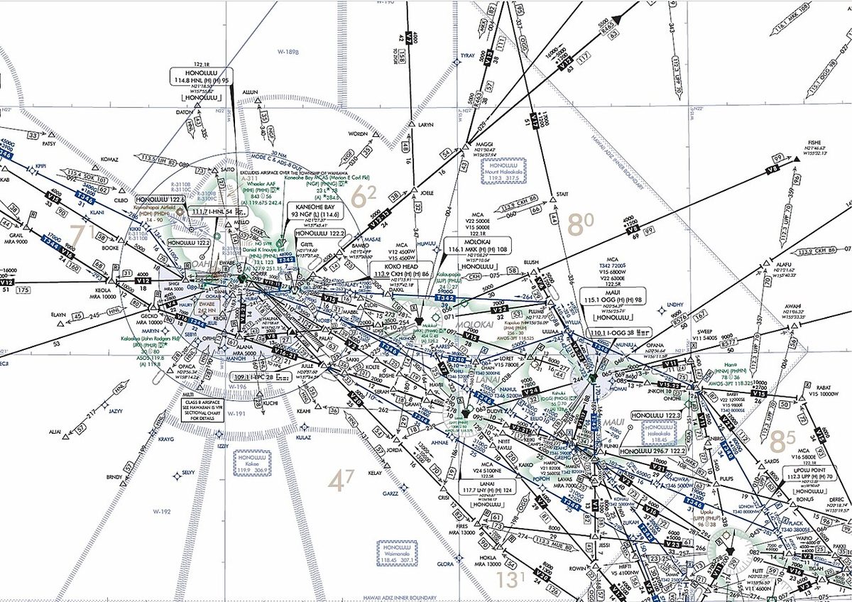
ICAO defines the minimum en-route altitude (MEA) as the altitude for an en-route segment that gives adequate reception of the relevant navigation aids and ATS communications, complies with the airspace structure and provides the required obstacle clearance. Under FAA rules the minimum en route altitude clears obstacles by 1,000 ft, or 2,000 ft in designated mountainous areas, across the full width of the airway and guarantees navigation signal for the whole segment.
The minimum obstacle clearance altitude (MOCA), which the FAA calls the minimum obstruction clearance altitude, gives the same obstacle clearance but no guarantee of signal. It is published below the MEA where reception, not terrain, sets the MEA; FAA charts mark it with an asterisk. Under 91.177 a pilot may fly below the MEA down to the MOCA if the navigation signals are available, and when navigating by VOR only within 22 NM of the station.
Several further figures complete the airway picture:
- Minimum reception altitude (MRA): the lowest altitude at which an intersection can be identified from the off-route navaid that defines it. It affects position fixing, not terrain clearance.
- Minimum crossing altitude (MCA): the altitude at which a fix must be crossed when the MEA beyond it rises and terrain close to the fix requires the climb to be finished early. Otherwise 91.177 requires the climb to a higher minimum to start immediately after passing the point where it applies.
- Maximum authorised altitude (MAA), spelt maximum authorized altitude by the FAA: the highest altitude at which reception is assured, set where a higher aircraft would pick up another station on the same frequency.
- Minimum turning altitude (MTA): an FAA figure for a turn at a fix, where the wider turning area, especially at the higher speeds flown above 10,000 ft, meets higher terrain. It is marked with the MCA flag and a note, must be reached by the turn point and is held until the aircraft joins the next route.

Off-route altitudes: MORA, Grid MORA and OROCA
Off airways there is no MEA. Jeppesen charts give a minimum off-route altitude (MORA) in two forms. A route MORA covers 10 NM either side of the route centreline. A Grid MORA, or grid minimum off-route altitude, covers each latitude-longitude square of the chart and is printed in hundreds of feet. Both clear the highest terrain and obstacles by 1,000 ft where these are at or below 5,000 ft, and by 2,000 ft where they are higher. The ICAO counterpart is the area minimum altitude (AMA).
The FAA publishes an off-route obstruction clearance altitude (OROCA) for each quadrangle of its en-route charts, with 1,000 ft of clearance, or 2,000 ft in designated mountainous areas. None of these figures promises navigation signal, radar or communications. Their proper uses are planning, situational awareness and contingencies: a drift-down after engine failure, an emergency descent, a diversion or doubt about position.
Exam tip: Grid MORA uses a 5,000 ft threshold for its 2,000 ft margin; the OROCA, the MEA and the FAA's MVA use designated mountainous areas instead.
Minimum sector altitude
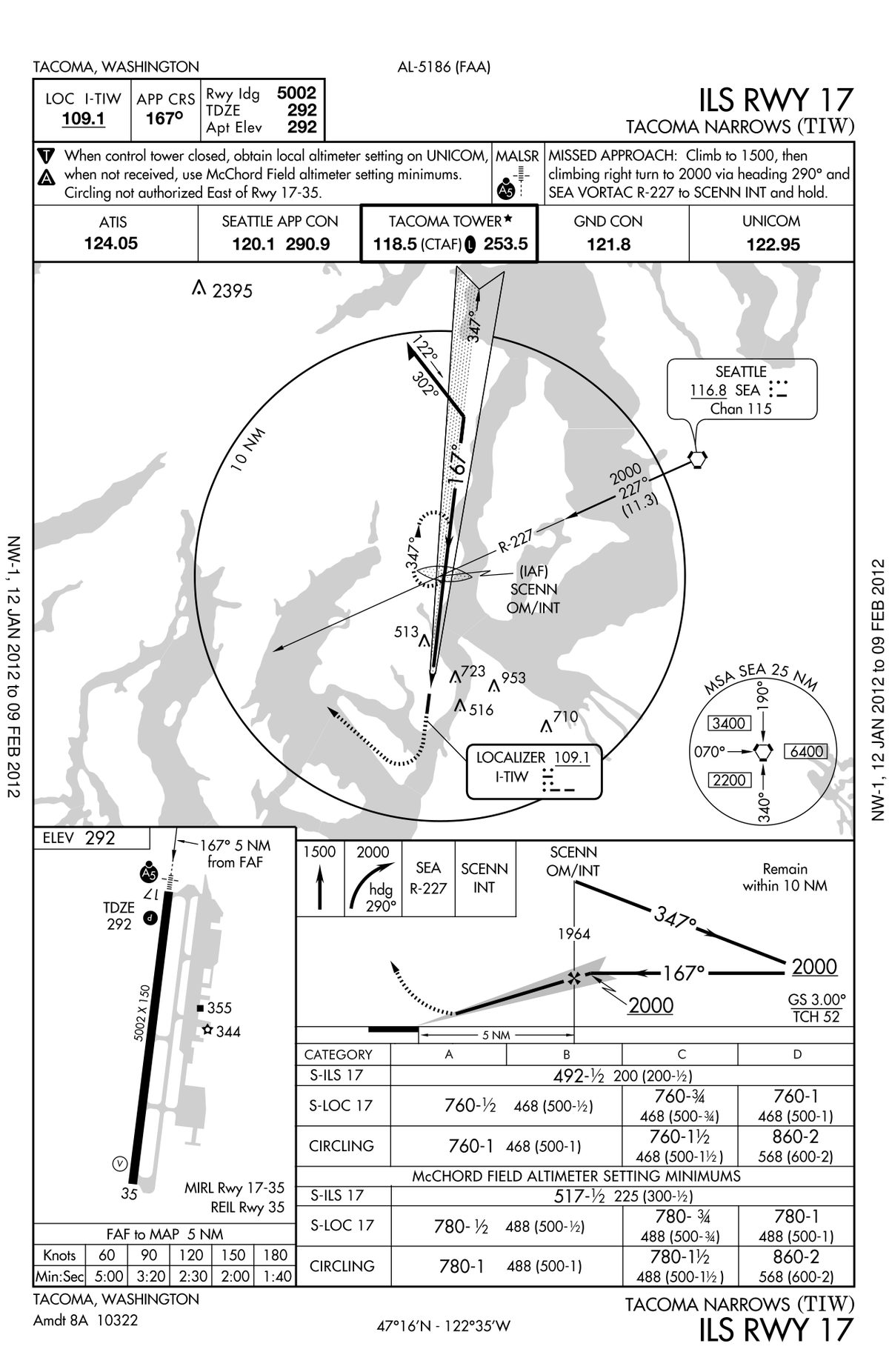
The minimum sector altitude (MSA) is printed on approach and departure charts. Under PANS-OPS it gives at least 300 m (984 ft) of clearance above all objects within a sector of a circle of 25 NM (46 km) radius, centred on a significant point, the aerodrome reference point or, for heliports, the heliport reference point. Obstacles in a 5 NM (9 km) buffer around each sector are included. Where the sector values differ by only about 300 ft, a single altitude may be published for all sectors. The FAA's equivalent, the minimum safe altitude, gives 1,000 ft of clearance within 25 NM and is described as for emergency use. RNAV approaches may instead show terminal arrival altitudes for sectors around the initial or intermediate fix.
The MSA guarantees no navigation signal, radar or radio coverage. In instrument conditions a pilot descends below it only when established on a published procedure, when radar-vectored, or with the terrain in sight and certain to remain so. It is the altitude to climb to after a terrain warning (see GPWS and TAWS) or when position is in doubt, and the highest MSA also appears in the CAVOK and "no significant cloud" criteria.
Radar vectoring altitudes
A minimum vectoring altitude (MVA) is the lowest altitude to which a controller will vector an IFR aircraft. In the United States it clears obstacles by 1,000 ft, or 2,000 ft in designated mountainous areas, within sectors whose boundaries lie at least 3 NM from the obstacle that sets them. Because the sectors follow local terrain, an MVA can be below the MEA or the MSA, and the FAA publishes MVA charts. In Europe, radar vectoring for an approach takes place within a defined radar vectoring area (RVA) around the aerodrome, and AIPs publish its minimum altitudes as minimum radar vectoring altitude (MRVA) or ATC surveillance minimum altitude charts, so that crews can check the altitudes they are given.
While vectoring, the controller is responsible for terrain clearance, and ICAO requires the air traffic services authority to give controllers minimum altitudes already corrected for temperature. The pilot still keeps an independent check: a clearance below a known minimum should be queried, not simply accepted.
Cold temperature altitude corrections
A pressure altimeter converts pressure to altitude using the International Standard Atmosphere. In colder air the pressure levels lie closer together, so the altimeter over-reads and the aircraft is lower than indicated. The error is zero at the elevation of the station whose altimeter setting is in use and grows with height above it. A cold temperature correction, or cold temperature altitude correction, is the amount added to a published minimum altitude to restore the intended clearance.
PANS-OPS gives a rule of thumb: add 4 per cent of the height above the altimeter setting source for every 10 °C below ISA, about 4 ft per 1,000 ft per degree. It is safe only for temperatures above −15 °C; colder than that, the ICAO table or its formula is used. Some values from the table, in feet to add, by height above the altimeter setting source:
| Aerodrome temperature | 500 ft | 1,000 ft | 2,000 ft | 3,000 ft | 5,000 ft |
|---|---|---|---|---|---|
| 0 °C | 30 | 60 | 120 | 170 | 280 |
| −10 °C | 50 | 100 | 200 | 290 | 490 |
| −20 °C | 70 | 140 | 280 | 420 | 710 |
| −30 °C | 100 | 190 | 380 | 570 | 950 |
| −40 °C | 120 | 240 | 480 | 720 | 1,210 |
For example, a final approach fix at 2,500 ft on a QNH from a 500 ft aerodrome reporting −30 °C is 2,000 ft above the source. The table gives 380 ft, so the fix is crossed at 2,880 ft, rounded up to 2,900 ft. The 4 per cent rule would give only about 350 ft, because −30 °C is outside its range.
Note: meteorology and flight planning questions often apply 4 ft per 1,000 ft per degree of ISA deviation to the whole altitude, for example to find the true altitude at a flight level. Approach corrections under PANS-OPS use the height above the altimeter setting source and the reported aerodrome temperature.
When the State's published threshold is reached, the pilot-in-command corrects every barometric minimum relied on for terrain clearance: MSA, en-route minima, initial, intermediate and final approach fix altitudes, step-down fixes, DA/H or MDA/H and missed approach altitudes. Flight levels are not corrected for separation, since all aircraft share the same error, but the lowest usable flight level must allow for both temperature and a QNH below 1013 hPa. Radio altimeter heights, such as a Category II decision height, and GNSS geometric altitude are unaffected (see radio altimeter). Any correction that changes an altitude assigned by ATC must be passed to the controller. The method, including the lowest usable flight level, is worked through in cold-weather altimetry.
Cold Temperature Airports and FMS compensation
The FAA introduced Cold Temperature Restricted Airports (CTRA), now published as Cold Temperature Airports (CTA): airports where cold temperature error could erode obstacle clearance on an approach. Their approach charts carry a snowflake and a temperature in °C. At or below that reported temperature, pilots correct either all segments, from the initial approach fix to the missed approach holding altitude, or only the individual segments listed by the FAA, using the ICAO table. Corrections on any segment except the final must be given to ATC. RNAV approaches with LNAV/VNAV minima also carry temperature limits, because a barometric vertical path flies lower in cold air.
FMS temperature compensation lets some flight management systems correct procedure altitudes and the barometric vertical path automatically. Crews must not add a manual correction on top of it, must still tell ATC of corrected altitudes, and should remember that an ILS glide path, like an SBAS vertical path, is fixed in space while the barometric altitudes printed beside it are not (see instrument approach procedures).
Exam tip: colder than ISA, true altitude is lower than indicated. The correction grows with height above the altimeter setting source, not above sea level or the terrain, and it is always added.
Frequently asked questions
What is the difference between MEA and MOCA?
Both clear obstacles along the whole airway segment by the same margin, 1,000 ft or 2,000 ft in FAA designated mountainous areas. The minimum en-route altitude also guarantees reception of the navigation aids defining the segment and, under ICAO, ATS communications. The MOCA guarantees obstacle clearance only; under FAA rules a pilot may fly down to it, but when navigating by VOR only within 22 NM of the station.
What does the minimum sector altitude guarantee?
The MSA gives at least 300 m (984 ft, usually quoted as 1,000 ft) of clearance above all obstacles within 25 NM of the navaid, fix or aerodrome reference point on which it is centred, with a 5 NM buffer around each sector under ICAO criteria. It guarantees no navigation signal, radar or radio coverage. It is a safe altitude for emergencies and orientation, not a route to be flown.
What is the minimum IFR altitude when none is published?
Under SERA.5015 it is 1,000 ft (300 m) above the highest obstacle within 8 km of the aircraft's estimated position, or 2,000 ft (600 m) over high terrain or in mountainous areas. Under 14 CFR 91.177 the FAA requires 1,000 ft above the highest obstacle within 4 NM of the course to be flown, or 2,000 ft in a designated mountainous area.
How do you apply a cold temperature correction?
Work out the height of the published altitude above the elevation of the altimeter setting source, find the correction for that height and the reported temperature in the ICAO table, add it and round up. As a rule of thumb, add 4 per cent of that height for every 10 °C below ISA, which is safe only above −15 °C. Tell ATC about any corrected altitude that differs from one assigned or published.
What are Grid MORA and OROCA?
Both are off-route altitudes printed in each latitude-longitude square of an en-route chart. Jeppesen's Grid MORA clears the highest terrain and obstacles in the square by 1,000 ft, or by 2,000 ft where they exceed 5,000 ft. The FAA's OROCA uses 1,000 ft, or 2,000 ft in designated mountainous areas. Neither guarantees navigation signal, radar or communications coverage.
What is a Cold Temperature Airport?
It is a US airport where the FAA has found that cold temperature altimeter error could erode obstacle clearance on an approach. The approach chart carries a snowflake symbol and a temperature. When the reported temperature is at or below it, pilots correct the approach altitudes, either on all segments or only on the segments listed, and tell ATC of corrections on any segment except the final.
Test yourself on Minimum Safe Altitudes and Cold Temperature Corrections
The v1prep banks cover this topic in General and Radio Navigation (061/062), with a worked explanation for every answer. EASA ATPL, PPL, IR and CPL, the FAA written tests and A320/B737 type ratings.
Start practising →Sources and further reading
- SKYbrary, Altimeter Temperature Error Correction
- ICAO EUR OPS Bulletin 2015_001, Cold temperature corrections
- FAA Aeronautical Information Manual, Chapter 7 Section 3, Cold Temperature Barometric Altimeter Errors, Setting Procedures and Cold Temperature Airports
- FAA Aeronautical Information Manual, Chapter 5 Section 3, En Route Procedures
- 14 CFR 91.177, Minimum altitudes for IFR operations
- Commission Implementing Regulation (EU) No 923/2012, Standardised European Rules of the Air (SERA)
- SKYbrary, Minimum Vectoring Altitude (MVA)
- CASA Visual Flight Rules Guide, Lowest safe altitude
Library articles are written for study and exam preparation. They do not replace your aircraft's approved documentation, your operator's procedures or the regulations themselves.